You are here: Home > Network List > IC - New China Digital Seismograph Network Stations List
> Station HIA Hailar, Neimenggu Province, China > Earthquake Result Viewer
HIA Hailar, Neimenggu Province, China - Earthquake Result Viewer

| Earthquake location: |
Washington |
| Earthquake latitude/longitude: |
47.1/-122.7 |
| Earthquake time(UTC): |
2001/02/28 (059) 18:54:32 GMT |
| Earthquake Depth: |
52 km |
| Earthquake Magnitude: |
6.5 MB, 6.6 MS, 6.8 MW, 6.7 ME |
| Earthquake Catalog/Contributor: |
WHDF/NEIC |
|
| Network: |
IC New China Digital Seismograph Network |
| Station: |
HIA Hailar, Neimenggu Province, China |
| Lat/Lon: |
49.27 N/119.74 E |
| Elevation: |
610 m |
|
| Distance: |
69.8 deg |
| Az: |
321.757 deg |
| Baz: |
40.164 deg |
| Ray Param: |
0.055310167 |
| Estimated Moho Depth: |
11.75 km |
| Estimated Crust Vp/Vs: |
1.60 |
| Assumed Crust Vp: |
6.577 km/s |
| Estimated Crust Vs: |
4.11 km/s |
| Estimated Crust Poisson's Ratio: |
0.18 |
|
| Radial Match: |
97.93981 % |
| Radial Bump: |
365 |
| Transverse Match: |
93.31713 % |
| Transverse Bump: |
400 |
| SOD ConfigId: |
3744 |
| Insert Time: |
2010-03-04 22:04:25.338 +0000 |
| GWidth: |
2.5 |
| Max Bumps: |
400 |
| Tol: |
0.001 |
|
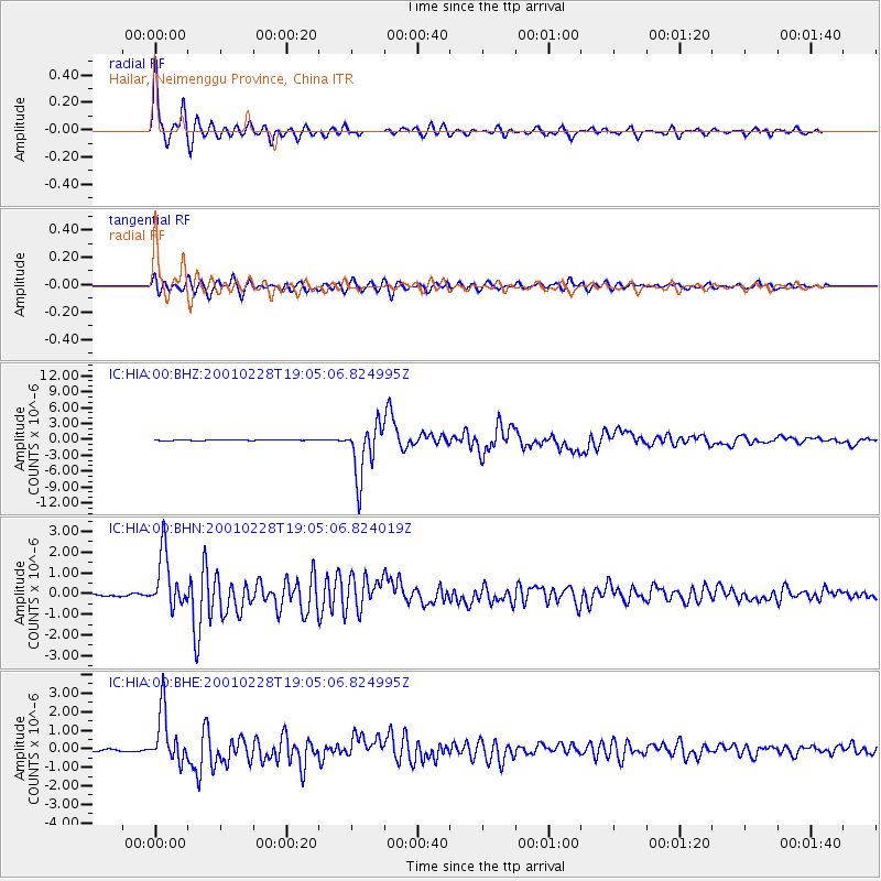
Signal To Noise
| Channel | StoN | STA | LTA |
| IC:HIA:00:BHN:20010228T19:05:06.824019Z | 24.628223 | 1.3322802E-6 | 5.4095672E-8 |
| IC:HIA:00:BHE:20010228T19:05:06.824995Z | 27.416456 | 1.3984028E-6 | 5.1005962E-8 |
| IC:HIA:00:BHZ:20010228T19:05:06.824995Z | 57.499756 | 5.0478216E-6 | 8.778857E-8 |
| Arrivals |
| Ps | 1.1 SECOND |
| PpPs | 4.4 SECOND |
| PsPs/PpSs | 5.6 SECOND |


