You are here: Home > Network List > IC - New China Digital Seismograph Network Stations List
> Station HIA Hailar, Neimenggu Province, China > Earthquake Result Viewer
HIA Hailar, Neimenggu Province, China - Earthquake Result Viewer

| Earthquake location: |
Southeast Of Loyalty Islands |
| Earthquake latitude/longitude: |
-22.3/169.7 |
| Earthquake time(UTC): |
2004/01/03 (003) 16:23:21 GMT |
| Earthquake Depth: |
22 km |
| Earthquake Magnitude: |
6.4 MB, 7.1 MS, 7.1 MW, 6.8 MW |
| Earthquake Catalog/Contributor: |
WHDF/NEIC |
|
| Network: |
IC New China Digital Seismograph Network |
| Station: |
HIA Hailar, Neimenggu Province, China |
| Lat/Lon: |
49.27 N/119.74 E |
| Elevation: |
610 m |
|
| Distance: |
83.9 deg |
| Az: |
329.721 deg |
| Baz: |
134.514 deg |
| Ray Param: |
0.045828674 |
| Estimated Moho Depth: |
38.25 km |
| Estimated Crust Vp/Vs: |
1.64 |
| Assumed Crust Vp: |
6.577 km/s |
| Estimated Crust Vs: |
4.004 km/s |
| Estimated Crust Poisson's Ratio: |
0.21 |
|
| Radial Match: |
97.82601 % |
| Radial Bump: |
333 |
| Transverse Match: |
83.78827 % |
| Transverse Bump: |
400 |
| SOD ConfigId: |
7314 |
| Insert Time: |
2010-03-04 22:07:40.025 +0000 |
| GWidth: |
2.5 |
| Max Bumps: |
400 |
| Tol: |
0.001 |
|
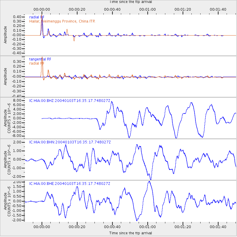
Signal To Noise
| Channel | StoN | STA | LTA |
| IC:HIA:00:BHN:20040103T16:35:17.748027Z | 11.405216 | 5.164113E-7 | 4.5278522E-8 |
| IC:HIA:00:BHE:20040103T16:35:17.748027Z | 13.05174 | 4.988409E-7 | 3.822026E-8 |
| IC:HIA:00:BHZ:20040103T16:35:17.748027Z | 26.320347 | 2.5395732E-6 | 9.648707E-8 |
| Arrivals |
| Ps | 3.8 SECOND |
| PpPs | 15 SECOND |
| PsPs/PpSs | 19 SECOND |


