You are here: Home > Network List > IC - New China Digital Seismograph Network Stations List
> Station HIA Hailar, Neimenggu Province, China > Earthquake Result Viewer
HIA Hailar, Neimenggu Province, China - Earthquake Result Viewer
| Earthquake location: |
Timor Region |
| Earthquake latitude/longitude: |
-8.2/124.9 |
| Earthquake time(UTC): |
2004/11/11 (316) 21:26:41 GMT |
| Earthquake Depth: |
10 km |
| Earthquake Magnitude: |
6.5 MB, 7.3 MS, 7.5 MW, 7.4 MW |
| Earthquake Catalog/Contributor: |
WHDF/NEIC |
|
| Network: |
IC New China Digital Seismograph Network |
| Station: |
HIA Hailar, Neimenggu Province, China |
| Lat/Lon: |
49.27 N/119.74 E |
| Elevation: |
610 m |
|
| Distance: |
57.4 deg |
| Az: |
356.014 deg |
| Baz: |
173.969 deg |
| Ray Param: |
0.06354603 |
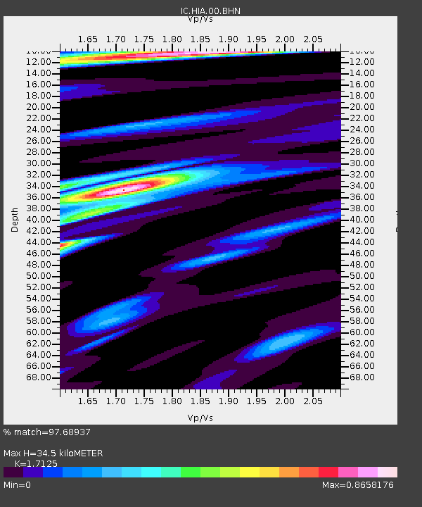
| Estimated Moho Depth: |
34.5 km |
| Estimated Crust Vp/Vs: |
1.71 |
| Assumed Crust Vp: |
6.577 km/s |
| Estimated Crust Vs: |
3.84 km/s |
| Estimated Crust Poisson's Ratio: |
0.24 |
|
| Radial Match: |
97.68937 % |
| Radial Bump: |
400 |
| Transverse Match: |
90.56838 % |
| Transverse Bump: |
400 |
| SOD ConfigId: |
2459 |
| Insert Time: |
2010-03-04 22:08:40.512 +0000 |
| GWidth: |
2.5 |
| Max Bumps: |
400 |
| Tol: |
0.001 |
|

Signal To Noise
| Channel | StoN | STA | LTA |
| IC:HIA:00:BHN:20041111T21:35:58.28501Z | 5.594869 | 8.1837794E-7 | 1.4627294E-7 |
| IC:HIA:00:BHE:20041111T21:35:58.28501Z | 0.85930073 | 9.200971E-8 | 1.07075095E-7 |
| IC:HIA:00:BHZ:20041111T21:35:58.28501Z | 5.414127 | 1.7832339E-6 | 3.2936686E-7 |
| Arrivals |
| Ps | 3.9 SECOND |
| PpPs | 13 SECOND |
| PsPs/PpSs | 17 SECOND |


