You are here: Home > Network List > IC - New China Digital Seismograph Network Stations List
> Station HIA Hailar, Neimenggu Province, China > Earthquake Result Viewer
HIA Hailar, Neimenggu Province, China - Earthquake Result Viewer
| Earthquake location: |
Sulawesi, Indonesia |
| Earthquake latitude/longitude: |
-5.6/122.1 |
| Earthquake time(UTC): |
2005/02/19 (050) 00:04:43 GMT |
| Earthquake Depth: |
10 km |
| Earthquake Magnitude: |
6.3 MB, 6.3 MS, 6.5 MW, 6.4 MW |
| Earthquake Catalog/Contributor: |
WHDF/NEIC |
|
| Network: |
IC New China Digital Seismograph Network |
| Station: |
HIA Hailar, Neimenggu Province, China |
| Lat/Lon: |
49.27 N/119.74 E |
| Elevation: |
610 m |
|
| Distance: |
54.6 deg |
| Az: |
358.083 deg |
| Baz: |
177.086 deg |
| Ray Param: |
0.06532118 |
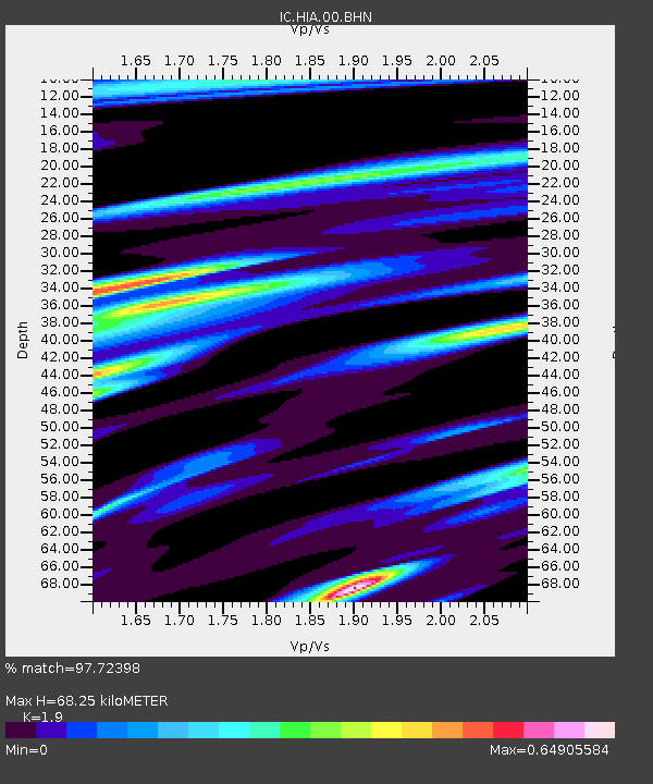
| Estimated Moho Depth: |
68.25 km |
| Estimated Crust Vp/Vs: |
1.90 |
| Assumed Crust Vp: |
6.577 km/s |
| Estimated Crust Vs: |
3.461 km/s |
| Estimated Crust Poisson's Ratio: |
0.31 |
|
| Radial Match: |
97.72398 % |
| Radial Bump: |
313 |
| Transverse Match: |
92.02479 % |
| Transverse Bump: |
400 |
| SOD ConfigId: |
2455 |
| Insert Time: |
2010-03-04 22:09:46.067 +0000 |
| GWidth: |
2.5 |
| Max Bumps: |
400 |
| Tol: |
0.001 |
|
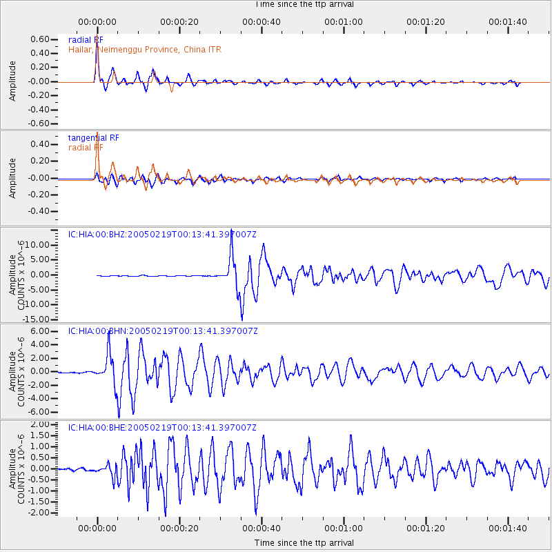
Signal To Noise
| Channel | StoN | STA | LTA |
| IC:HIA:00:BHN:20050219T00:13:41.397007Z | 40.972157 | 2.2984188E-6 | 5.6097093E-8 |
| IC:HIA:00:BHE:20050219T00:13:41.397007Z | 3.4928403 | 2.7070342E-7 | 7.750238E-8 |
| IC:HIA:00:BHZ:20050219T00:13:41.397007Z | 54.45936 | 5.5072546E-6 | 1.01125956E-7 |
| Arrivals |
| Ps | 9.8 SECOND |
| PpPs | 29 SECOND |
| PsPs/PpSs | 38 SECOND |


