You are here: Home > Network List > IC - New China Digital Seismograph Network Stations List
> Station HIA Hailar, Neimenggu Province, China > Earthquake Result Viewer
HIA Hailar, Neimenggu Province, China - Earthquake Result Viewer
| Earthquake location: |
Off W Coast Of Northern Sumatra |
| Earthquake latitude/longitude: |
2.8/96.0 |
| Earthquake time(UTC): |
2008/02/20 (051) 08:08:30 GMT |
| Earthquake Depth: |
26 km |
| Earthquake Magnitude: |
6.5 MB, 7.5 MS, 7.4 MW, 7.4 MW |
| Earthquake Catalog/Contributor: |
WHDF/NEIC |
|
| Network: |
IC New China Digital Seismograph Network |
| Station: |
HIA Hailar, Neimenggu Province, China |
| Lat/Lon: |
49.27 N/119.74 E |
| Elevation: |
610 m |
|
| Distance: |
50.6 deg |
| Az: |
19.992 deg |
| Baz: |
211.421 deg |
| Ray Param: |
0.06791737 |
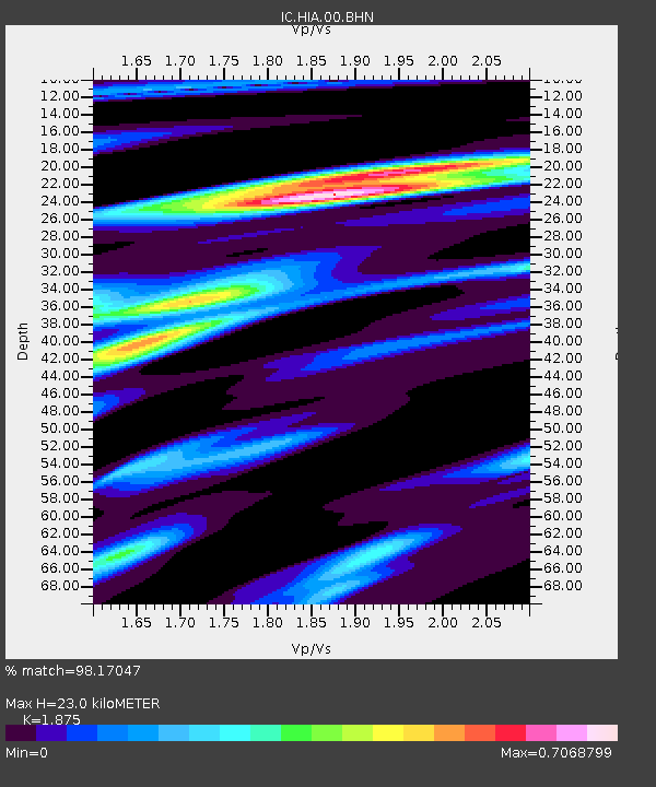
| Estimated Moho Depth: |
23.0 km |
| Estimated Crust Vp/Vs: |
1.88 |
| Assumed Crust Vp: |
6.577 km/s |
| Estimated Crust Vs: |
3.508 km/s |
| Estimated Crust Poisson's Ratio: |
0.30 |
|
| Radial Match: |
98.17047 % |
| Radial Bump: |
319 |
| Transverse Match: |
85.65544 % |
| Transverse Bump: |
400 |
| SOD ConfigId: |
2564 |
| Insert Time: |
2010-03-04 22:12:39.156 +0000 |
| GWidth: |
2.5 |
| Max Bumps: |
400 |
| Tol: |
0.001 |
|
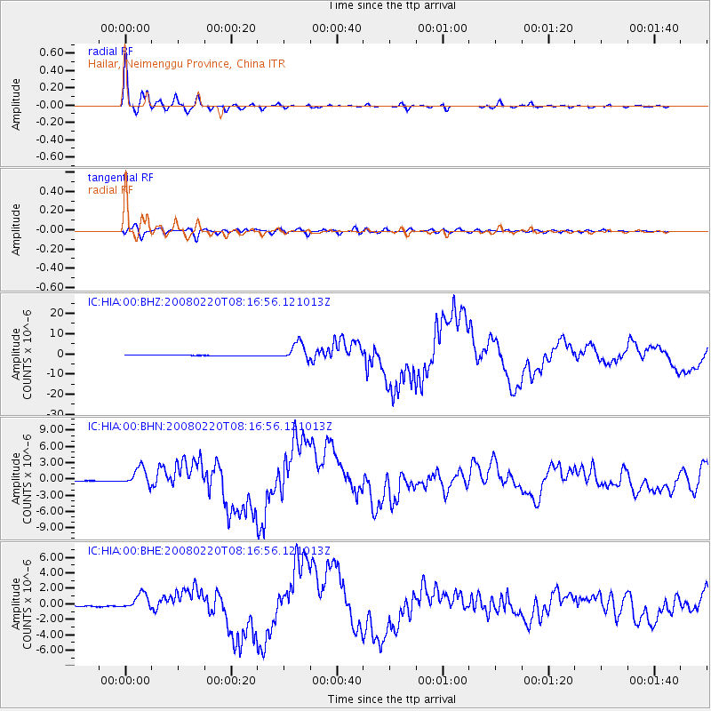
Signal To Noise
| Channel | StoN | STA | LTA |
| IC:HIA:00:BHN:20080220T08:16:56.121013Z | 15.631238 | 1.6410895E-6 | 1.0498781E-7 |
| IC:HIA:00:BHE:20080220T08:16:56.121013Z | 13.9275255 | 1.0386519E-6 | 7.457548E-8 |
| IC:HIA:00:BHZ:20080220T08:16:56.121013Z | 24.305416 | 4.3731575E-6 | 1.7992522E-7 |
| Arrivals |
| Ps | 3.2 SECOND |
| PpPs | 9.5 SECOND |
| PsPs/PpSs | 13 SECOND |


