HIA Hailar, Neimenggu Province, China - Earthquake Result Viewer
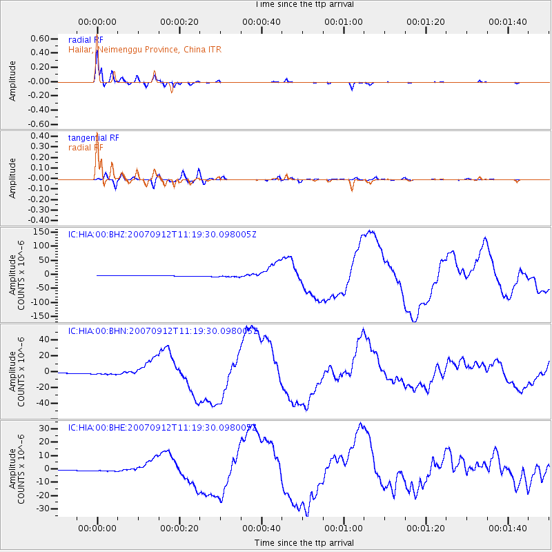
Earthquake location: Southern Sumatra, Indonesia
Earthquake latitude/longitude: -4.4/101.4
Earthquake time(UTC): 2007/09/12 (255) 11:10:26 GMT
Earthquake Depth: 34 km
Earthquake Magnitude: 6.9 MB, 8.5 MS, 8.4 MW, 8.0 ME
Earthquake Catalog/Contributor: WHDF/NEIC
Network: IC New China Digital Seismograph Network
Station: HIA Hailar, Neimenggu Province, China
Lat/Lon: 49.27 N/119.74 E
Elevation: 610 m
Distance: 55.8 deg
Az: 14.453 deg
Baz: 202.328 deg
Ray Param: 0.064479955
Estimated Moho Depth: 36.5 km
Estimated Crust Vp/Vs: 1.60
Assumed Crust Vp: 6.577 km/s
Estimated Crust Vs: 4.11 km/s
Estimated Crust Poisson's Ratio: 0.18
Radial Match: 98.89757 %
Radial Bump: 301
Transverse Match: 89.1856 %
Transverse Bump: 400
SOD ConfigId: 2564
Insert Time: 2010-03-04 22:13:34.966 +0000
GWidth: 2.5
Max Bumps: 400
Tol: 0.001

Signal To Noise

ChannelStoNSTALTA
IC:HIA:00:BHN:20070912T11:19:30.098005Z3.73771792.1281137E-65.6936176E-7
IC:HIA:00:BHE:20070912T11:19:30.098005Z4.1199018.727317E-72.1183315E-7
IC:HIA:00:BHZ:20070912T11:19:30.098005Z3.23026283.6510885E-61.130276E-6
Arrivals
Ps3.5 SECOND
PpPs14 SECOND
PsPs/PpSs17 SECOND