You are here: Home > Network List > IC - New China Digital Seismograph Network Stations List
> Station HIA Hailar, Neimenggu Province, China > Earthquake Result Viewer
HIA Hailar, Neimenggu Province, China - Earthquake Result Viewer
| Earthquake location: |
Bismarck Sea |
| Earthquake latitude/longitude: |
-3.3/146.8 |
| Earthquake time(UTC): |
2007/06/07 (158) 00:40:38 GMT |
| Earthquake Depth: |
4.7 km |
| Earthquake Magnitude: |
5.8 MB, 6.2 MS, 6.2 MW, 6.2 MW |
| Earthquake Catalog/Contributor: |
WHDF/NEIC |
|
| Network: |
IC New China Digital Seismograph Network |
| Station: |
HIA Hailar, Neimenggu Province, China |
| Lat/Lon: |
49.27 N/119.74 E |
| Elevation: |
610 m |
|
| Distance: |
57.4 deg |
| Az: |
339.308 deg |
| Baz: |
147.417 deg |
| Ray Param: |
0.063544676 |
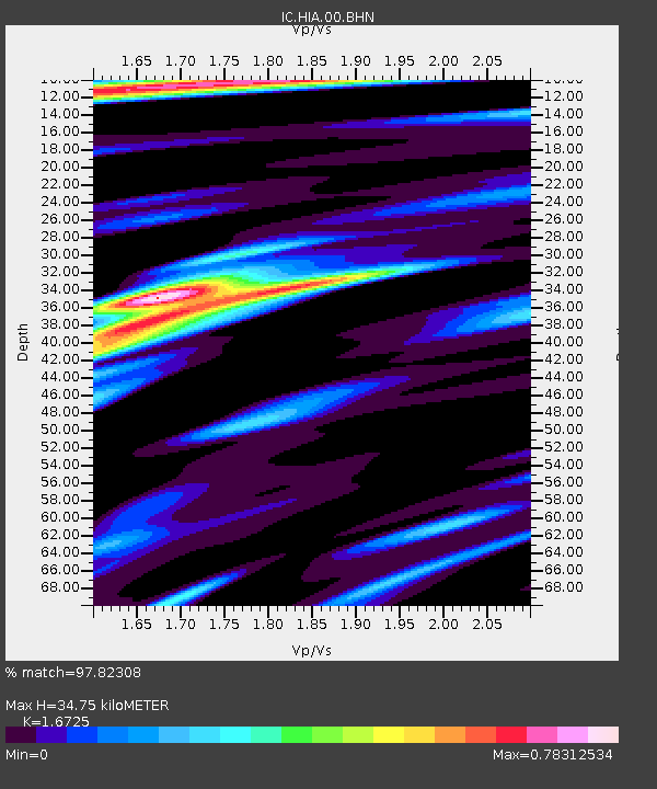
| Estimated Moho Depth: |
34.75 km |
| Estimated Crust Vp/Vs: |
1.67 |
| Assumed Crust Vp: |
6.577 km/s |
| Estimated Crust Vs: |
3.932 km/s |
| Estimated Crust Poisson's Ratio: |
0.22 |
|
| Radial Match: |
97.82308 % |
| Radial Bump: |
224 |
| Transverse Match: |
86.76714 % |
| Transverse Bump: |
400 |
| SOD ConfigId: |
2564 |
| Insert Time: |
2010-03-04 22:14:22.461 +0000 |
| GWidth: |
2.5 |
| Max Bumps: |
400 |
| Tol: |
0.001 |
|

Signal To Noise
| Channel | StoN | STA | LTA |
| IC:HIA:00:BHN:20070607T00:49:56.286006Z | 3.0459836 | 9.215209E-8 | 3.025364E-8 |
| IC:HIA:00:BHE:20070607T00:49:56.286006Z | 2.7022219 | 9.428328E-8 | 3.489102E-8 |
| IC:HIA:00:BHZ:20070607T00:49:56.286006Z | 4.6274695 | 3.396723E-7 | 7.340346E-8 |
| Arrivals |
| Ps | 3.8 SECOND |
| PpPs | 13 SECOND |
| PsPs/PpSs | 17 SECOND |


