You are here: Home > Network List > IC - New China Digital Seismograph Network Stations List
> Station HIA Hailar, Neimenggu Province, China > Earthquake Result Viewer
HIA Hailar, Neimenggu Province, China - Earthquake Result Viewer
| Earthquake location: |
Northern Molucca Sea |
| Earthquake latitude/longitude: |
1.1/126.3 |
| Earthquake time(UTC): |
2007/01/21 (021) 11:27:45 GMT |
| Earthquake Depth: |
22 km |
| Earthquake Magnitude: |
6.7 MB, 7.3 MS, 7.5 MW, 7.3 MW |
| Earthquake Catalog/Contributor: |
WHDF/NEIC |
|
| Network: |
IC New China Digital Seismograph Network |
| Station: |
HIA Hailar, Neimenggu Province, China |
| Lat/Lon: |
49.27 N/119.74 E |
| Elevation: |
610 m |
|
| Distance: |
48.3 deg |
| Az: |
354.269 deg |
| Baz: |
171.233 deg |
| Ray Param: |
0.069390394 |
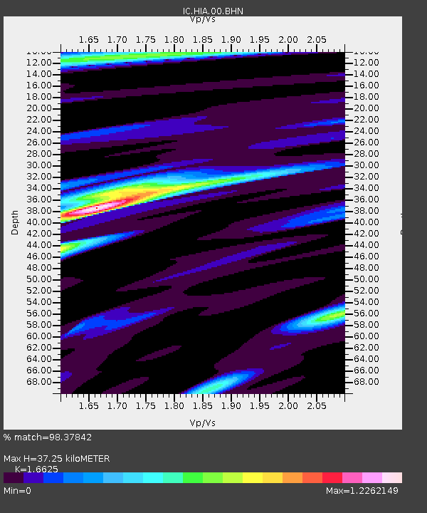
| Estimated Moho Depth: |
37.25 km |
| Estimated Crust Vp/Vs: |
1.66 |
| Assumed Crust Vp: |
6.577 km/s |
| Estimated Crust Vs: |
3.956 km/s |
| Estimated Crust Poisson's Ratio: |
0.22 |
|
| Radial Match: |
98.37842 % |
| Radial Bump: |
374 |
| Transverse Match: |
92.03096 % |
| Transverse Bump: |
400 |
| SOD ConfigId: |
2564 |
| Insert Time: |
2010-03-04 22:14:50.492 +0000 |
| GWidth: |
2.5 |
| Max Bumps: |
400 |
| Tol: |
0.001 |
|
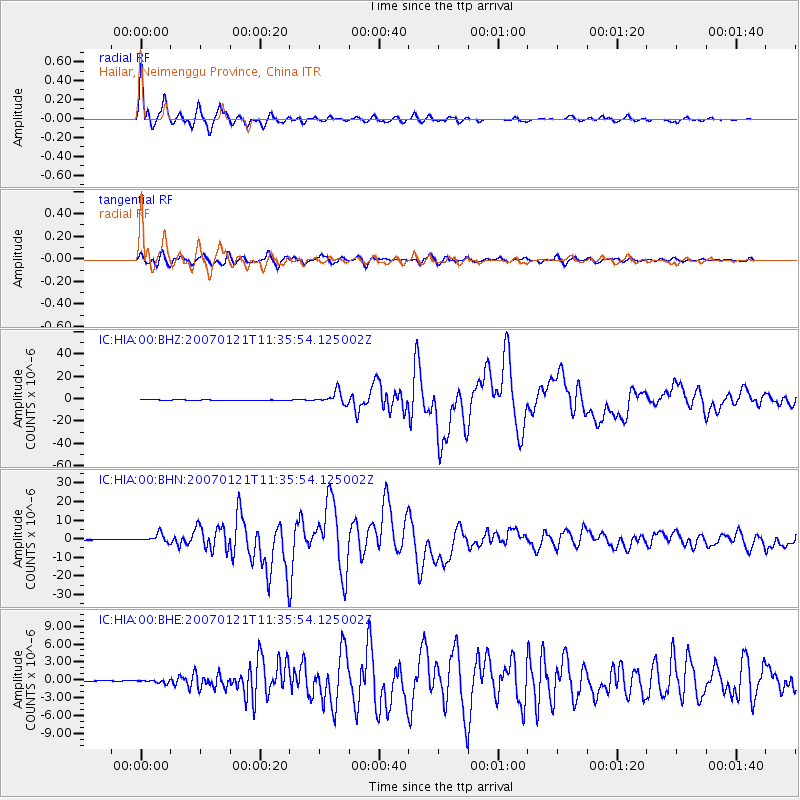
Signal To Noise
| Channel | StoN | STA | LTA |
| IC:HIA:00:BHN:20070121T11:35:54.125002Z | 29.062923 | 2.2293107E-6 | 7.670634E-8 |
| IC:HIA:00:BHE:20070121T11:35:54.125002Z | 6.282845 | 2.543385E-7 | 4.0481417E-8 |
| IC:HIA:00:BHZ:20070121T11:35:54.125002Z | 46.595245 | 5.4041593E-6 | 1.15980924E-7 |
| Arrivals |
| Ps | 4.0 SECOND |
| PpPs | 14 SECOND |
| PsPs/PpSs | 18 SECOND |


