You are here: Home > Network List > IC - New China Digital Seismograph Network Stations List
> Station HIA Hailar, Neimenggu Province, China > Earthquake Result Viewer
HIA Hailar, Neimenggu Province, China - Earthquake Result Viewer
| Earthquake location: |
Mariana Islands |
| Earthquake latitude/longitude: |
18.9/145.4 |
| Earthquake time(UTC): |
2007/10/31 (304) 03:30:17 GMT |
| Earthquake Depth: |
223 km |
| Earthquake Magnitude: |
6.2 MB, 7.2 MW, 7.2 MW |
| Earthquake Catalog/Contributor: |
WHDF/NEIC |
|
| Network: |
IC New China Digital Seismograph Network |
| Station: |
HIA Hailar, Neimenggu Province, China |
| Lat/Lon: |
49.27 N/119.74 E |
| Elevation: |
610 m |
|
| Distance: |
36.6 deg |
| Az: |
331.662 deg |
| Baz: |
136.681 deg |
| Ray Param: |
0.07572552 |
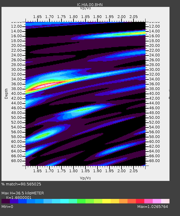
| Estimated Moho Depth: |
36.5 km |
| Estimated Crust Vp/Vs: |
1.68 |
| Assumed Crust Vp: |
6.577 km/s |
| Estimated Crust Vs: |
3.915 km/s |
| Estimated Crust Poisson's Ratio: |
0.23 |
|
| Radial Match: |
98.565025 % |
| Radial Bump: |
270 |
| Transverse Match: |
91.34797 % |
| Transverse Bump: |
400 |
| SOD ConfigId: |
2564 |
| Insert Time: |
2010-03-04 22:15:02.974 +0000 |
| GWidth: |
2.5 |
| Max Bumps: |
400 |
| Tol: |
0.001 |
|

Signal To Noise
| Channel | StoN | STA | LTA |
| IC:HIA:00:BHN:20071031T03:36:32.196011Z | 19.922636 | 9.4455817E-7 | 4.741131E-8 |
| IC:HIA:00:BHE:20071031T03:36:32.196011Z | 17.833048 | 1.0220696E-6 | 5.7313233E-8 |
| IC:HIA:00:BHZ:20071031T03:36:32.196011Z | 38.82342 | 2.9053156E-6 | 7.48341E-8 |
| Arrivals |
| Ps | 4.1 SECOND |
| PpPs | 14 SECOND |
| PsPs/PpSs | 18 SECOND |


