HIA Hailar, Neimenggu Province, China - Earthquake Result Viewer
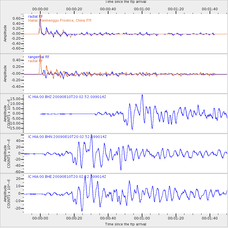
Earthquake location: Andaman Islands, India Region
Earthquake latitude/longitude: 14.1/92.9
Earthquake time(UTC): 2009/08/10 (222) 19:55:35 GMT
Earthquake Depth: 4.7 km
Earthquake Magnitude: 6.9 MB, 7.6 MS, 7.5 MW, 7.5 MW
Earthquake Catalog/Contributor: WHDF/NEIC
Network: IC New China Digital Seismograph Network
Station: HIA Hailar, Neimenggu Province, China
Lat/Lon: 49.27 N/119.74 E
Elevation: 610 m
Distance: 41.4 deg
Az: 26.571 deg
Baz: 221.494 deg
Ray Param: 0.073820464
Estimated Moho Depth: 19.5 km
Estimated Crust Vp/Vs: 2.10
Assumed Crust Vp: 6.577 km/s
Estimated Crust Vs: 3.136 km/s
Estimated Crust Poisson's Ratio: 0.35
Radial Match: 98.071266 %
Radial Bump: 264
Transverse Match: 94.06762 %
Transverse Bump: 400
SOD ConfigId: 2622
Insert Time: 2010-03-04 22:15:23.032 +0000
GWidth: 2.5
Max Bumps: 400
Tol: 0.001

Signal To Noise

ChannelStoNSTALTA
IC:HIA:00:BHN:20090810T20:02:52.099014Z17.3717142.1157823E-61.2179468E-7
IC:HIA:00:BHE:20090810T20:02:52.099014Z10.2803077.8148054E-77.601724E-8
IC:HIA:00:BHZ:20090810T20:02:52.099014Z9.4867046.766276E-77.132378E-8
Arrivals
Ps3.5 SECOND
PpPs8.6 SECOND
PsPs/PpSs12 SECOND