You are here: Home > Network List > IC - New China Digital Seismograph Network Stations List
> Station HIA Hailar, Neimenggu Province, China > Earthquake Result Viewer
HIA Hailar, Neimenggu Province, China - Earthquake Result Viewer
*The percent match for this event was below the threshold and hence no stack was calculated.
| Earthquake location: |
Vanuatu Islands |
| Earthquake latitude/longitude: |
-17.1/168.5 |
| Earthquake time(UTC): |
2008/11/04 (309) 18:35:45 GMT |
| Earthquake Depth: |
206 km |
| Earthquake Magnitude: |
5.7 MB, 6.3 MW, 6.3 MW |
| Earthquake Catalog/Contributor: |
WHDF/NEIC |
|
| Network: |
IC New China Digital Seismograph Network |
| Station: |
HIA Hailar, Neimenggu Province, China |
| Lat/Lon: |
49.27 N/119.74 E |
| Elevation: |
610 m |
|
| Distance: |
78.9 deg |
| Az: |
329.896 deg |
| Baz: |
132.934 deg |
| Ray Param: |
$rayparam |
*The percent match for this event was below the threshold and hence was not used in the summary stack. |
|
| Radial Match: |
69.90703 % |
| Radial Bump: |
377 |
| Transverse Match: |
59.579273 % |
| Transverse Bump: |
316 |
| SOD ConfigId: |
2658 |
| Insert Time: |
2010-03-04 22:18:38.467 +0000 |
| GWidth: |
2.5 |
| Max Bumps: |
400 |
| Tol: |
0.001 |
|
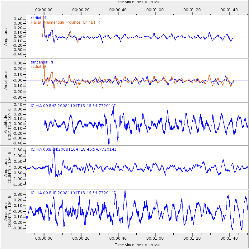
Signal To Noise
| Channel | StoN | STA | LTA |
| IC:HIA:00:BHN:20081104T18:46:54.772014Z | 1.8215187 | 2.7541628E-7 | 1.5120148E-7 |
| IC:HIA:00:BHE:20081104T18:46:54.772014Z | 1.1438115 | 8.7536215E-8 | 7.6530284E-8 |
| IC:HIA:00:BHZ:20081104T18:46:54.772014Z | 1.50297 | 1.0292021E-7 | 6.847789E-8 |
| Arrivals |
| Ps | |
| PpPs | |
| PsPs/PpSs | |


