You are here: Home > Network List > IC - New China Digital Seismograph Network Stations List
> Station HIA Hailar, Neimenggu Province, China > Earthquake Result Viewer
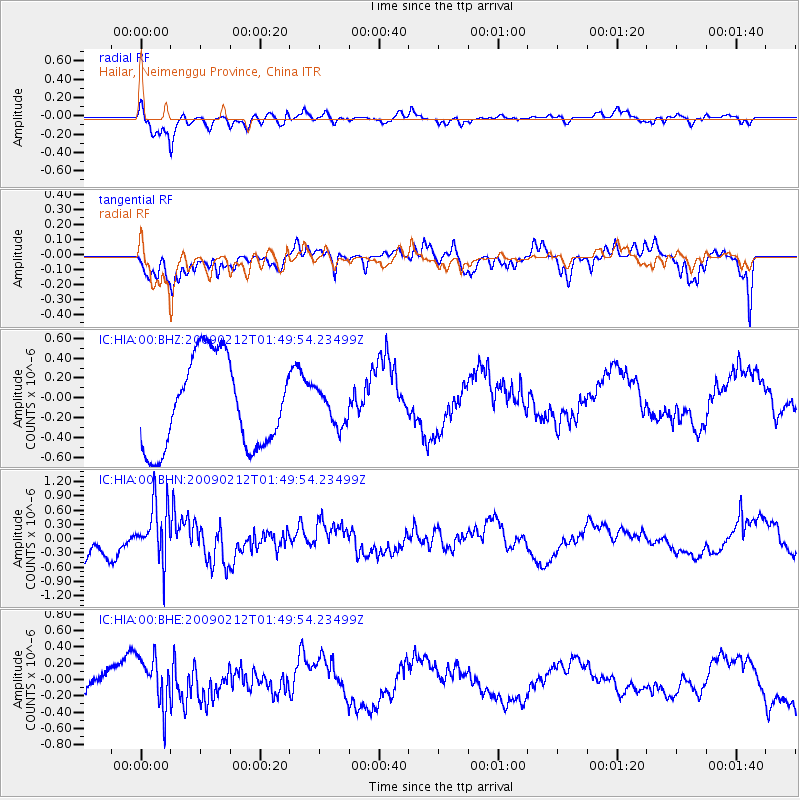
HIA Hailar, Neimenggu Province, China - Earthquake Result Viewer
*The percent match for this event was below the threshold and hence no stack was calculated.
| Earthquake location: |
Talaud Islands, Indonesia |
| Earthquake latitude/longitude: |
4.0/126.6 |
| Earthquake time(UTC): |
2009/02/12 (043) 01:42:09 GMT |
| Earthquake Depth: |
42 km |
| Earthquake Magnitude: |
5.5 MB |
| Earthquake Catalog/Contributor: |
WHDF/NEIC |
|
| Network: |
IC New China Digital Seismograph Network |
| Station: |
HIA Hailar, Neimenggu Province, China |
| Lat/Lon: |
49.27 N/119.74 E |
| Elevation: |
610 m |
|
| Distance: |
45.5 deg |
| Az: |
353.677 deg |
| Baz: |
170.345 deg |
| Ray Param: |
$rayparam |
*The percent match for this event was below the threshold and hence was not used in the summary stack. |
|
| Radial Match: |
82.18313 % |
| Radial Bump: |
400 |
| Transverse Match: |
48.387627 % |
| Transverse Bump: |
400 |
| SOD ConfigId: |
2658 |
| Insert Time: |
2010-03-04 22:18:40.583 +0000 |
| GWidth: |
2.5 |
| Max Bumps: |
400 |
| Tol: |
0.001 |
|
Signal To Noise
| Channel | StoN | STA | LTA |
| IC:HIA:00:BHN:20090212T01:49:54.23499Z | 2.7972648 | 6.05227E-7 | 2.1636386E-7 |
| IC:HIA:00:BHE:20090212T01:49:54.23499Z | 1.5377444 | 3.089458E-7 | 2.0090843E-7 |
| IC:HIA:00:BHZ:20090212T01:49:54.23499Z | 0.38581333 | 1.7383111E-7 | 4.5055756E-7 |
| Arrivals |
| Ps | |
| PpPs | |
| PsPs/PpSs | |


