You are here: Home > Network List > IC - New China Digital Seismograph Network Stations List
> Station HIA Hailar, Neimenggu Province, China > Earthquake Result Viewer
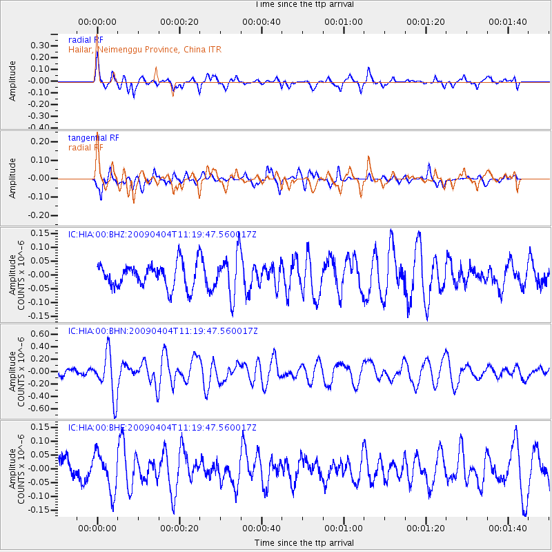
HIA Hailar, Neimenggu Province, China - Earthquake Result Viewer
*The percent match for this event was below the threshold and hence no stack was calculated.
| Earthquake location: |
Tonga Islands Region |
| Earthquake latitude/longitude: |
-22.5/-174.7 |
| Earthquake time(UTC): |
2009/04/04 (094) 11:07:12 GMT |
| Earthquake Depth: |
35 km |
| Earthquake Magnitude: |
5.5 MB, 5.4 MS, 5.5 MW, 5.5 MW |
| Earthquake Catalog/Contributor: |
WHDF/NEIC |
|
| Network: |
IC New China Digital Seismograph Network |
| Station: |
HIA Hailar, Neimenggu Province, China |
| Lat/Lon: |
49.27 N/119.74 E |
| Elevation: |
610 m |
|
| Distance: |
92.1 deg |
| Az: |
323.346 deg |
| Baz: |
122.573 deg |
| Ray Param: |
$rayparam |
*The percent match for this event was below the threshold and hence was not used in the summary stack. |
|
| Radial Match: |
71.97606 % |
| Radial Bump: |
396 |
| Transverse Match: |
46.221348 % |
| Transverse Bump: |
346 |
| SOD ConfigId: |
2760 |
| Insert Time: |
2010-03-04 22:18:43.074 +0000 |
| GWidth: |
2.5 |
| Max Bumps: |
400 |
| Tol: |
0.001 |
|
Signal To Noise
| Channel | StoN | STA | LTA |
| IC:HIA:00:BHN:20090404T11:19:47.560017Z | 9.39833 | 3.6333083E-7 | 3.8659085E-8 |
| IC:HIA:00:BHE:20090404T11:19:47.560017Z | 1.4767594 | 7.07705E-8 | 4.7922835E-8 |
| IC:HIA:00:BHZ:20090404T11:19:47.560017Z | 1.8433264 | 7.943768E-8 | 4.3094744E-8 |
| Arrivals |
| Ps | |
| PpPs | |
| PsPs/PpSs | |


