You are here: Home > Network List > IC - New China Digital Seismograph Network Stations List
> Station HIA Hailar, Neimenggu Province, China > Earthquake Result Viewer
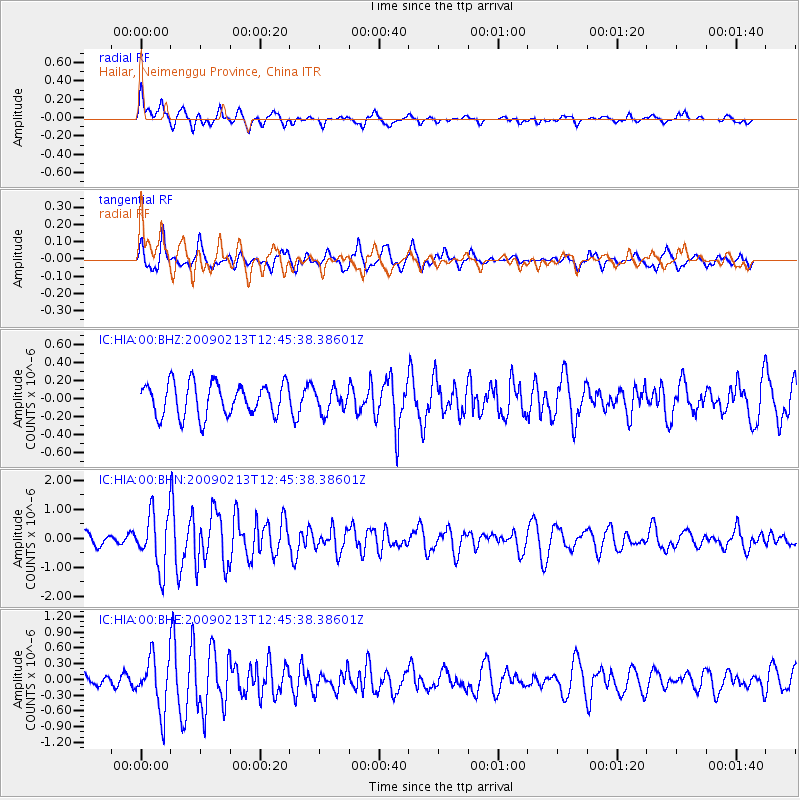
HIA Hailar, Neimenggu Province, China - Earthquake Result Viewer
*The percent match for this event was below the threshold and hence no stack was calculated.
| Earthquake location: |
Talaud Islands, Indonesia |
| Earthquake latitude/longitude: |
3.8/126.7 |
| Earthquake time(UTC): |
2009/02/13 (044) 12:37:51 GMT |
| Earthquake Depth: |
35 km |
| Earthquake Magnitude: |
5.5 MB, 5.2 MS, 5.6 MW, 5.3 MW |
| Earthquake Catalog/Contributor: |
WHDF/NEIC |
|
| Network: |
IC New China Digital Seismograph Network |
| Station: |
HIA Hailar, Neimenggu Province, China |
| Lat/Lon: |
49.27 N/119.74 E |
| Elevation: |
610 m |
|
| Distance: |
45.7 deg |
| Az: |
353.617 deg |
| Baz: |
170.25 deg |
| Ray Param: |
$rayparam |
*The percent match for this event was below the threshold and hence was not used in the summary stack. |
|
| Radial Match: |
77.10529 % |
| Radial Bump: |
400 |
| Transverse Match: |
70.291626 % |
| Transverse Bump: |
400 |
| SOD ConfigId: |
2658 |
| Insert Time: |
2010-03-04 22:18:44.567 +0000 |
| GWidth: |
2.5 |
| Max Bumps: |
400 |
| Tol: |
0.001 |
|
Signal To Noise
| Channel | StoN | STA | LTA |
| IC:HIA:00:BHN:20090213T12:45:38.38601Z | 3.8277106 | 9.650715E-7 | 2.5212762E-7 |
| IC:HIA:00:BHE:20090213T12:45:38.38601Z | 2.8879652 | 5.0646935E-7 | 1.7537238E-7 |
| IC:HIA:00:BHZ:20090213T12:45:38.38601Z | 0.6935214 | 1.2463052E-7 | 1.797068E-7 |
| Arrivals |
| Ps | |
| PpPs | |
| PsPs/PpSs | |


