You are here: Home > Network List > IC - New China Digital Seismograph Network Stations List
> Station HIA Hailar, Neimenggu Province, China > Earthquake Result Viewer
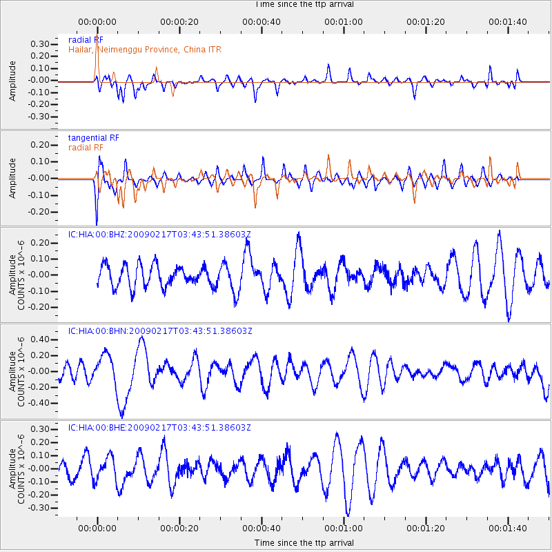
HIA Hailar, Neimenggu Province, China - Earthquake Result Viewer
*The percent match for this event was below the threshold and hence no stack was calculated.
| Earthquake location: |
Kermadec Islands, New Zealand |
| Earthquake latitude/longitude: |
-30.7/-178.6 |
| Earthquake time(UTC): |
2009/02/17 (048) 03:30:53 GMT |
| Earthquake Depth: |
13 km |
| Earthquake Magnitude: |
5.5 MS, 5.4 MB, 6.0 MW, 6.0 MW |
| Earthquake Catalog/Contributor: |
WHDF/NEIC |
|
| Network: |
IC New China Digital Seismograph Network |
| Station: |
HIA Hailar, Neimenggu Province, China |
| Lat/Lon: |
49.27 N/119.74 E |
| Elevation: |
610 m |
|
| Distance: |
96.7 deg |
| Az: |
324.523 deg |
| Baz: |
130.274 deg |
| Ray Param: |
$rayparam |
*The percent match for this event was below the threshold and hence was not used in the summary stack. |
|
| Radial Match: |
27.371847 % |
| Radial Bump: |
366 |
| Transverse Match: |
40.99404 % |
| Transverse Bump: |
400 |
| SOD ConfigId: |
2658 |
| Insert Time: |
2010-03-04 22:18:46.692 +0000 |
| GWidth: |
2.5 |
| Max Bumps: |
400 |
| Tol: |
0.001 |
|
Signal To Noise
| Channel | StoN | STA | LTA |
| IC:HIA:00:BHN:20090217T03:43:51.38603Z | 2.1787808 | 1.9044037E-7 | 8.740685E-8 |
| IC:HIA:00:BHE:20090217T03:43:51.38603Z | 1.3306433 | 9.1841905E-8 | 6.902068E-8 |
| IC:HIA:00:BHZ:20090217T03:43:51.38603Z | 1.4339038 | 9.255573E-8 | 6.4548075E-8 |
| Arrivals |
| Ps | |
| PpPs | |
| PsPs/PpSs | |


