You are here: Home > Network List > IC - New China Digital Seismograph Network Stations List
> Station HIA Hailar, Neimenggu Province, China > Earthquake Result Viewer
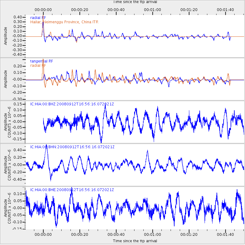
HIA Hailar, Neimenggu Province, China - Earthquake Result Viewer
*The percent match for this event was below the threshold and hence no stack was calculated.
| Earthquake location: |
Southeast Of Loyalty Islands |
| Earthquake latitude/longitude: |
-21.7/170.5 |
| Earthquake time(UTC): |
2008/09/12 (256) 16:44:30 GMT |
| Earthquake Depth: |
116 km |
| Earthquake Magnitude: |
5.8 MW, 5.4 MB, 5.8 MW |
| Earthquake Catalog/Contributor: |
WHDF/NEIC |
|
| Network: |
IC New China Digital Seismograph Network |
| Station: |
HIA Hailar, Neimenggu Province, China |
| Lat/Lon: |
49.27 N/119.74 E |
| Elevation: |
610 m |
|
| Distance: |
83.8 deg |
| Az: |
329.329 deg |
| Baz: |
133.59 deg |
| Ray Param: |
$rayparam |
*The percent match for this event was below the threshold and hence was not used in the summary stack. |
|
| Radial Match: |
65.724045 % |
| Radial Bump: |
400 |
| Transverse Match: |
56.320564 % |
| Transverse Bump: |
342 |
| SOD ConfigId: |
2560 |
| Insert Time: |
2010-03-04 22:18:49.489 +0000 |
| GWidth: |
2.5 |
| Max Bumps: |
400 |
| Tol: |
0.001 |
|
Signal To Noise
| Channel | StoN | STA | LTA |
| IC:HIA:00:BHN:20080912T16:56:16.072021Z | 3.3341444 | 2.8935867E-7 | 8.6786486E-8 |
| IC:HIA:00:BHE:20080912T16:56:16.072021Z | 0.7098453 | 4.0658502E-8 | 5.7277976E-8 |
| IC:HIA:00:BHZ:20080912T16:56:16.072021Z | 2.8115158 | 9.157523E-8 | 3.257148E-8 |
| Arrivals |
| Ps | |
| PpPs | |
| PsPs/PpSs | |


