You are here: Home > Network List > IC - New China Digital Seismograph Network Stations List
> Station HIA Hailar, Neimenggu Province, China > Earthquake Result Viewer
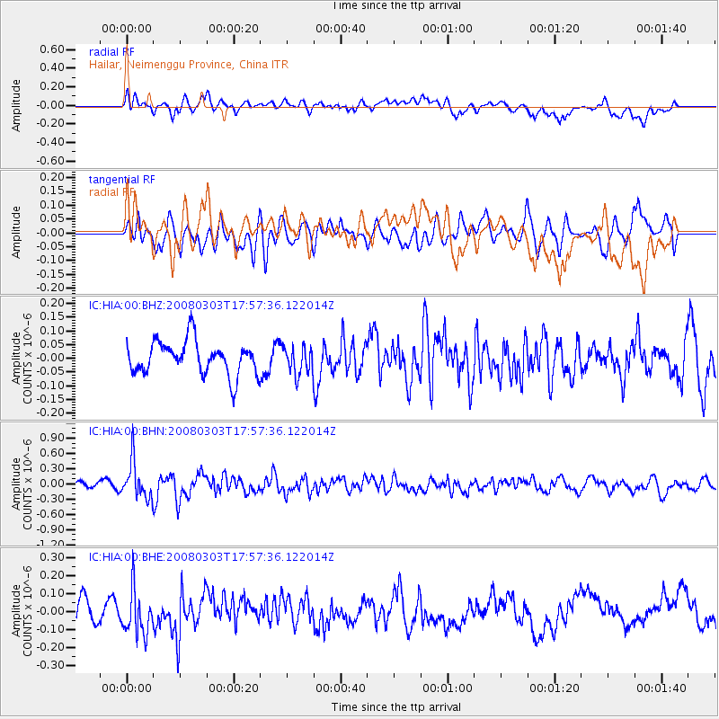
HIA Hailar, Neimenggu Province, China - Earthquake Result Viewer
*The percent match for this event was below the threshold and hence no stack was calculated.
| Earthquake location: |
Southern Sumatra, Indonesia |
| Earthquake latitude/longitude: |
-4.5/101.5 |
| Earthquake time(UTC): |
2008/03/03 (063) 17:48:32 GMT |
| Earthquake Depth: |
28 km |
| Earthquake Magnitude: |
5.6 MB, 5.0 MS |
| Earthquake Catalog/Contributor: |
WHDF/NEIC |
|
| Network: |
IC New China Digital Seismograph Network |
| Station: |
HIA Hailar, Neimenggu Province, China |
| Lat/Lon: |
49.27 N/119.74 E |
| Elevation: |
610 m |
|
| Distance: |
55.8 deg |
| Az: |
14.386 deg |
| Baz: |
202.22 deg |
| Ray Param: |
$rayparam |
*The percent match for this event was below the threshold and hence was not used in the summary stack. |
|
| Radial Match: |
62.669514 % |
| Radial Bump: |
400 |
| Transverse Match: |
51.427814 % |
| Transverse Bump: |
400 |
| SOD ConfigId: |
2504 |
| Insert Time: |
2010-03-04 22:18:50.336 +0000 |
| GWidth: |
2.5 |
| Max Bumps: |
400 |
| Tol: |
0.001 |
|
Signal To Noise
| Channel | StoN | STA | LTA |
| IC:HIA:00:BHN:20080303T17:57:36.122014Z | 4.657379 | 3.681663E-7 | 7.90501E-8 |
| IC:HIA:00:BHE:20080303T17:57:36.122014Z | 1.6116004 | 1.2533415E-7 | 7.776999E-8 |
| IC:HIA:00:BHZ:20080303T17:57:36.122014Z | 0.8337263 | 5.057475E-8 | 6.0661094E-8 |
| Arrivals |
| Ps | |
| PpPs | |
| PsPs/PpSs | |


