You are here: Home > Network List > IC - New China Digital Seismograph Network Stations List
> Station HIA Hailar, Neimenggu Province, China > Earthquake Result Viewer
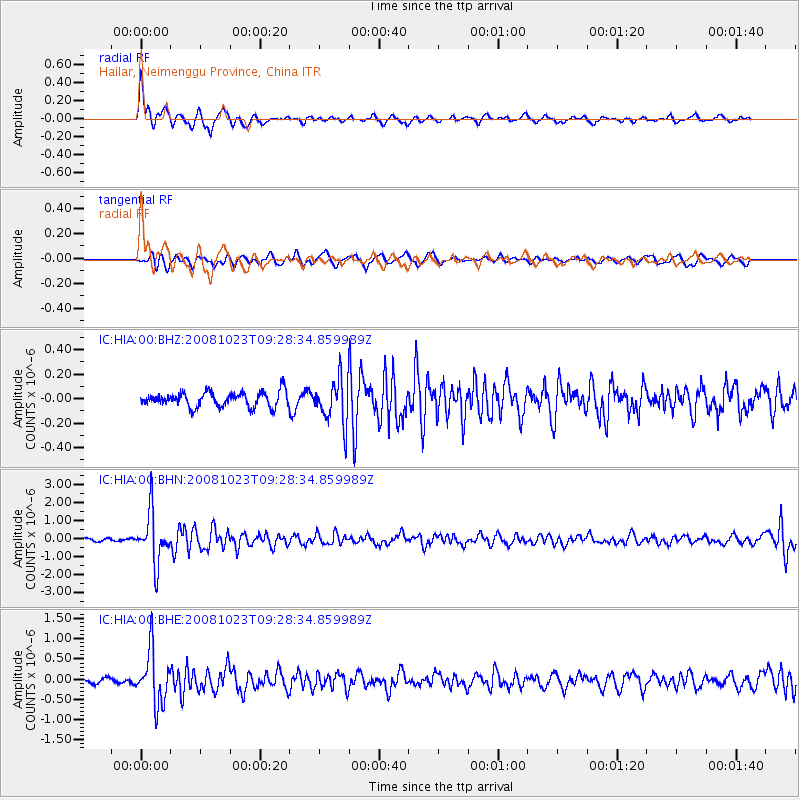
HIA Hailar, Neimenggu Province, China - Earthquake Result Viewer
*The percent match for this event was below the threshold and hence no stack was calculated.
| Earthquake location: |
Mindanao, Philippines |
| Earthquake latitude/longitude: |
6.0/125.8 |
| Earthquake time(UTC): |
2008/10/23 (297) 09:21:15 GMT |
| Earthquake Depth: |
130 km |
| Earthquake Magnitude: |
5.8 MB, 5.7 MW, 5.6 MW |
| Earthquake Catalog/Contributor: |
WHDF/NEIC |
|
| Network: |
IC New China Digital Seismograph Network |
| Station: |
HIA Hailar, Neimenggu Province, China |
| Lat/Lon: |
49.27 N/119.74 E |
| Elevation: |
610 m |
|
| Distance: |
43.5 deg |
| Az: |
354.253 deg |
| Baz: |
171.253 deg |
| Ray Param: |
$rayparam |
*The percent match for this event was below the threshold and hence was not used in the summary stack. |
|
| Radial Match: |
76.53969 % |
| Radial Bump: |
395 |
| Transverse Match: |
70.76394 % |
| Transverse Bump: |
400 |
| SOD ConfigId: |
2556 |
| Insert Time: |
2010-03-04 22:19:01.127 +0000 |
| GWidth: |
2.5 |
| Max Bumps: |
400 |
| Tol: |
0.001 |
|
Signal To Noise
| Channel | StoN | STA | LTA |
| IC:HIA:00:BHN:20081023T09:28:34.859989Z | 12.3735485 | 1.3899263E-6 | 1.12330454E-7 |
| IC:HIA:00:BHE:20081023T09:28:34.859989Z | 13.731068 | 6.5418766E-7 | 4.7642885E-8 |
| IC:HIA:00:BHZ:20081023T09:28:34.859989Z | 3.012527 | 1.8262381E-7 | 6.062147E-8 |
| Arrivals |
| Ps | |
| PpPs | |
| PsPs/PpSs | |


