You are here: Home > Network List > IC - New China Digital Seismograph Network Stations List
> Station HIA Hailar, Neimenggu Province, China > Earthquake Result Viewer
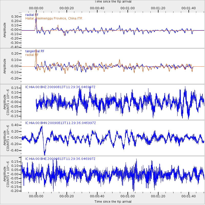
HIA Hailar, Neimenggu Province, China - Earthquake Result Viewer
*The percent match for this event was below the threshold and hence no stack was calculated.
| Earthquake location: |
Tonga Islands |
| Earthquake latitude/longitude: |
-21.7/-174.6 |
| Earthquake time(UTC): |
2009/08/13 (225) 11:17:01 GMT |
| Earthquake Depth: |
10 km |
| Earthquake Magnitude: |
5.6 MW, 5.3 MB |
| Earthquake Catalog/Contributor: |
WHDF/NEIC |
|
| Network: |
IC New China Digital Seismograph Network |
| Station: |
HIA Hailar, Neimenggu Province, China |
| Lat/Lon: |
49.27 N/119.74 E |
| Elevation: |
610 m |
|
| Distance: |
91.5 deg |
| Az: |
323.331 deg |
| Baz: |
121.999 deg |
| Ray Param: |
$rayparam |
*The percent match for this event was below the threshold and hence was not used in the summary stack. |
|
| Radial Match: |
65.16407 % |
| Radial Bump: |
400 |
| Transverse Match: |
54.29471 % |
| Transverse Bump: |
400 |
| SOD ConfigId: |
2622 |
| Insert Time: |
2010-03-04 22:19:08.960 +0000 |
| GWidth: |
2.5 |
| Max Bumps: |
400 |
| Tol: |
0.001 |
|
Signal To Noise
| Channel | StoN | STA | LTA |
| IC:HIA:00:BHN:20090813T11:29:36.046997Z | 2.8199255 | 1.84411E-7 | 6.539569E-8 |
| IC:HIA:00:BHE:20090813T11:29:36.046997Z | 1.0452607 | 4.6113126E-8 | 4.4116387E-8 |
| IC:HIA:00:BHZ:20090813T11:29:36.046997Z | 1.3404706 | 5.233058E-8 | 3.9038966E-8 |
| Arrivals |
| Ps | |
| PpPs | |
| PsPs/PpSs | |


