You are here: Home > Network List > IC - New China Digital Seismograph Network Stations List
> Station HIA Hailar, Neimenggu Province, China > Earthquake Result Viewer
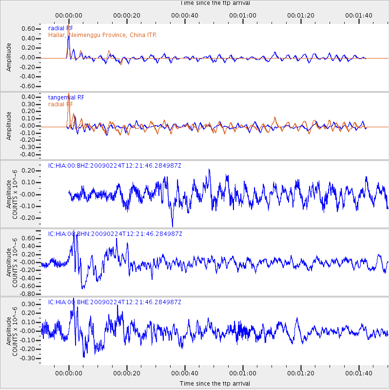
HIA Hailar, Neimenggu Province, China - Earthquake Result Viewer
*The percent match for this event was below the threshold and hence no stack was calculated.
| Earthquake location: |
Northern Sumatra, Indonesia |
| Earthquake latitude/longitude: |
1.4/97.2 |
| Earthquake time(UTC): |
2009/02/24 (055) 12:13:15 GMT |
| Earthquake Depth: |
35 km |
| Earthquake Magnitude: |
5.6 MB, 5.7 MS, 5.7 MW, 5.5 MW |
| Earthquake Catalog/Contributor: |
WHDF/NEIC |
|
| Network: |
IC New China Digital Seismograph Network |
| Station: |
HIA Hailar, Neimenggu Province, China |
| Lat/Lon: |
49.27 N/119.74 E |
| Elevation: |
610 m |
|
| Distance: |
51.4 deg |
| Az: |
18.752 deg |
| Baz: |
209.38 deg |
| Ray Param: |
$rayparam |
*The percent match for this event was below the threshold and hence was not used in the summary stack. |
|
| Radial Match: |
74.95302 % |
| Radial Bump: |
400 |
| Transverse Match: |
64.00172 % |
| Transverse Bump: |
400 |
| SOD ConfigId: |
2658 |
| Insert Time: |
2010-03-04 22:19:18.423 +0000 |
| GWidth: |
2.5 |
| Max Bumps: |
400 |
| Tol: |
0.001 |
|
Signal To Noise
| Channel | StoN | STA | LTA |
| IC:HIA:00:BHN:20090224T12:21:46.284987Z | 4.8100495 | 3.868371E-7 | 8.042268E-8 |
| IC:HIA:00:BHE:20090224T12:21:46.284987Z | 3.527237 | 1.4923927E-7 | 4.2310532E-8 |
| IC:HIA:00:BHZ:20090224T12:21:46.284987Z | 1.9253582 | 8.113893E-8 | 4.2142254E-8 |
| Arrivals |
| Ps | |
| PpPs | |
| PsPs/PpSs | |


