You are here: Home > Network List > IC - New China Digital Seismograph Network Stations List
> Station HIA Hailar, Neimenggu Province, China > Earthquake Result Viewer
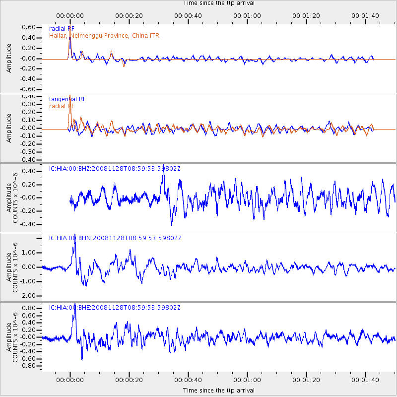
HIA Hailar, Neimenggu Province, China - Earthquake Result Viewer
*The percent match for this event was below the threshold and hence no stack was calculated.
| Earthquake location: |
Southern Sumatra, Indonesia |
| Earthquake latitude/longitude: |
-4.7/101.8 |
| Earthquake time(UTC): |
2008/11/28 (333) 08:50:48 GMT |
| Earthquake Depth: |
27 km |
| Earthquake Magnitude: |
5.7 MB, 5.9 MS, 5.8 MW, 5.8 MW |
| Earthquake Catalog/Contributor: |
WHDF/NEIC |
|
| Network: |
IC New China Digital Seismograph Network |
| Station: |
HIA Hailar, Neimenggu Province, China |
| Lat/Lon: |
49.27 N/119.74 E |
| Elevation: |
610 m |
|
| Distance: |
56.0 deg |
| Az: |
14.122 deg |
| Baz: |
201.79 deg |
| Ray Param: |
$rayparam |
*The percent match for this event was below the threshold and hence was not used in the summary stack. |
|
| Radial Match: |
68.82723 % |
| Radial Bump: |
400 |
| Transverse Match: |
61.829044 % |
| Transverse Bump: |
400 |
| SOD ConfigId: |
2658 |
| Insert Time: |
2010-03-04 22:19:21.444 +0000 |
| GWidth: |
2.5 |
| Max Bumps: |
400 |
| Tol: |
0.001 |
|
Signal To Noise
| Channel | StoN | STA | LTA |
| IC:HIA:00:BHN:20081128T08:59:53.59802Z | 7.4818087 | 8.731748E-7 | 1.1670638E-7 |
| IC:HIA:00:BHE:20081128T08:59:53.59802Z | 5.8489733 | 3.6630914E-7 | 6.262794E-8 |
| IC:HIA:00:BHZ:20081128T08:59:53.59802Z | 2.607924 | 2.0494605E-7 | 7.85859E-8 |
| Arrivals |
| Ps | |
| PpPs | |
| PsPs/PpSs | |


