You are here: Home > Network List > IC - New China Digital Seismograph Network Stations List
> Station HIA Hailar, Neimenggu Province, China > Earthquake Result Viewer
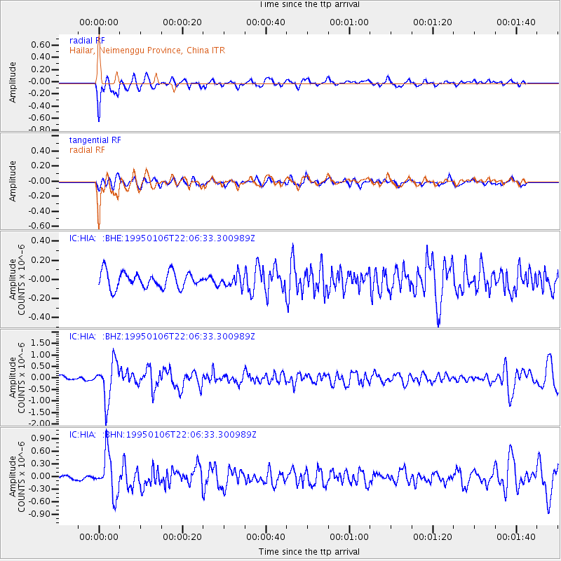
HIA Hailar, Neimenggu Province, China - Earthquake Result Viewer
*The percent match for this event was below the threshold and hence no stack was calculated.
| Earthquake location: |
Mindanao, Philippines |
| Earthquake latitude/longitude: |
9.2/126.2 |
| Earthquake time(UTC): |
1995/01/06 (006) 21:59:32 GMT |
| Earthquake Depth: |
61 km |
| Earthquake Magnitude: |
5.7 MB, 5.9 UNKNOWN, 5.7 MW |
| Earthquake Catalog/Contributor: |
WHDF/NEIC |
|
| Network: |
IC New China Digital Seismograph Network |
| Station: |
HIA Hailar, Neimenggu Province, China |
| Lat/Lon: |
49.27 N/119.74 E |
| Elevation: |
610 m |
|
| Distance: |
40.3 deg |
| Az: |
353.468 deg |
| Baz: |
170.127 deg |
| Ray Param: |
$rayparam |
*The percent match for this event was below the threshold and hence was not used in the summary stack. |
|
| Radial Match: |
85.67857 % |
| Radial Bump: |
400 |
| Transverse Match: |
65.85503 % |
| Transverse Bump: |
400 |
| SOD ConfigId: |
4480 |
| Insert Time: |
2010-03-04 22:19:28.687 +0000 |
| GWidth: |
2.5 |
| Max Bumps: |
400 |
| Tol: |
0.001 |
|
Signal To Noise
| Channel | StoN | STA | LTA |
| IC:HIA: :BHZ:19950106T22:06:33.300989Z | 8.9851265 | 8.5105813E-7 | 9.4718544E-8 |
| IC:HIA: :BHN:19950106T22:06:33.300989Z | 7.2416153 | 5.044197E-7 | 6.965569E-8 |
| IC:HIA: :BHE:19950106T22:06:33.300989Z | 0.7613734 | 6.353744E-8 | 8.345109E-8 |
| Arrivals |
| Ps | |
| PpPs | |
| PsPs/PpSs | |


