You are here: Home > Network List > IC - New China Digital Seismograph Network Stations List
> Station HIA Hailar, Neimenggu Province, China > Earthquake Result Viewer
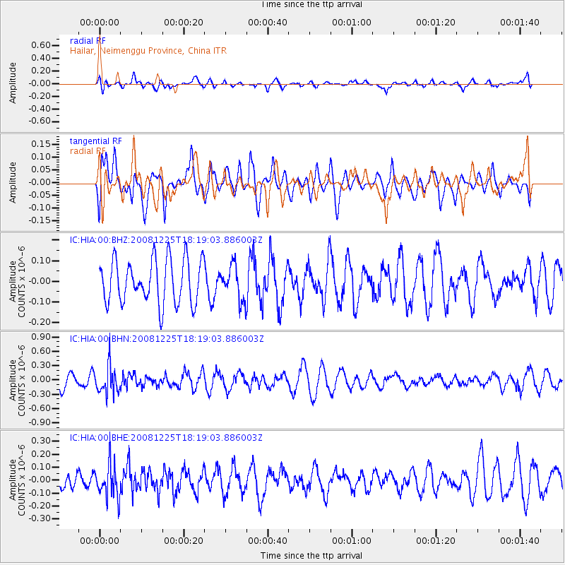
HIA Hailar, Neimenggu Province, China - Earthquake Result Viewer
*The percent match for this event was below the threshold and hence no stack was calculated.
| Earthquake location: |
Mindanao, Philippines |
| Earthquake latitude/longitude: |
5.3/124.3 |
| Earthquake time(UTC): |
2008/12/25 (360) 18:12:07 GMT |
| Earthquake Depth: |
432 km |
| Earthquake Magnitude: |
5.6 MB, 5.4 MW |
| Earthquake Catalog/Contributor: |
WHDF/NEIC |
|
| Network: |
IC New China Digital Seismograph Network |
| Station: |
HIA Hailar, Neimenggu Province, China |
| Lat/Lon: |
49.27 N/119.74 E |
| Elevation: |
610 m |
|
| Distance: |
44.0 deg |
| Az: |
355.736 deg |
| Baz: |
173.511 deg |
| Ray Param: |
$rayparam |
*The percent match for this event was below the threshold and hence was not used in the summary stack. |
|
| Radial Match: |
49.788364 % |
| Radial Bump: |
400 |
| Transverse Match: |
56.19392 % |
| Transverse Bump: |
400 |
| SOD ConfigId: |
2658 |
| Insert Time: |
2010-03-04 22:19:36.269 +0000 |
| GWidth: |
2.5 |
| Max Bumps: |
400 |
| Tol: |
0.001 |
|
Signal To Noise
| Channel | StoN | STA | LTA |
| IC:HIA:00:BHN:20081225T18:19:03.886003Z | 2.2620533 | 2.9736282E-7 | 1.3145704E-7 |
| IC:HIA:00:BHE:20081225T18:19:03.886003Z | 2.3139024 | 1.3494788E-7 | 5.832047E-8 |
| IC:HIA:00:BHZ:20081225T18:19:03.886003Z | 0.7993831 | 8.4503704E-8 | 1.05711145E-7 |
| Arrivals |
| Ps | |
| PpPs | |
| PsPs/PpSs | |


