You are here: Home > Network List > IC - New China Digital Seismograph Network Stations List
> Station HIA Hailar, Neimenggu Province, China > Earthquake Result Viewer
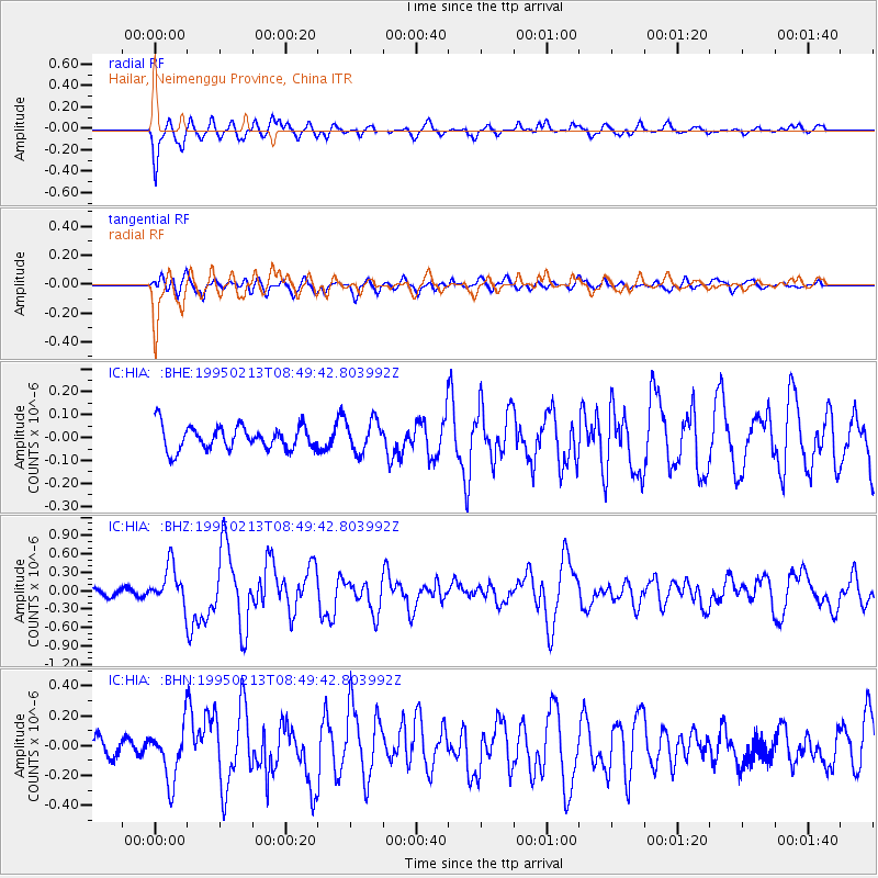
HIA Hailar, Neimenggu Province, China - Earthquake Result Viewer
*The percent match for this event was below the threshold and hence no stack was calculated.
| Earthquake location: |
Halmahera, Indonesia |
| Earthquake latitude/longitude: |
-1.4/127.5 |
| Earthquake time(UTC): |
1995/02/13 (044) 08:41:14 GMT |
| Earthquake Depth: |
25 km |
| Earthquake Magnitude: |
5.7 MB, 5.5 MS, 5.8 UNKNOWN |
| Earthquake Catalog/Contributor: |
WHDF/NEIC |
|
| Network: |
IC New China Digital Seismograph Network |
| Station: |
HIA Hailar, Neimenggu Province, China |
| Lat/Lon: |
49.27 N/119.74 E |
| Elevation: |
610 m |
|
| Distance: |
50.9 deg |
| Az: |
353.461 deg |
| Baz: |
169.991 deg |
| Ray Param: |
$rayparam |
*The percent match for this event was below the threshold and hence was not used in the summary stack. |
|
| Radial Match: |
82.61066 % |
| Radial Bump: |
400 |
| Transverse Match: |
43.656647 % |
| Transverse Bump: |
400 |
| SOD ConfigId: |
4480 |
| Insert Time: |
2010-03-04 22:19:39.160 +0000 |
| GWidth: |
2.5 |
| Max Bumps: |
400 |
| Tol: |
0.001 |
|
Signal To Noise
| Channel | StoN | STA | LTA |
| IC:HIA: :BHZ:19950213T08:49:42.803992Z | 4.704547 | 3.225977E-7 | 6.8571474E-8 |
| IC:HIA: :BHN:19950213T08:49:42.803992Z | 3.5471523 | 1.8262295E-7 | 5.1484385E-8 |
| IC:HIA: :BHE:19950213T08:49:42.803992Z | 1.3641267 | 7.023033E-8 | 5.148373E-8 |
| Arrivals |
| Ps | |
| PpPs | |
| PsPs/PpSs | |


