You are here: Home > Network List > IC - New China Digital Seismograph Network Stations List
> Station HIA Hailar, Neimenggu Province, China > Earthquake Result Viewer
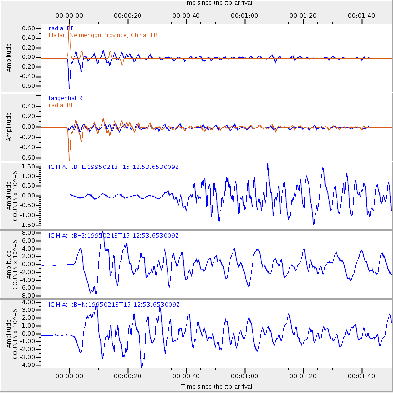
HIA Hailar, Neimenggu Province, China - Earthquake Result Viewer
*The percent match for this event was below the threshold and hence no stack was calculated.
| Earthquake location: |
Halmahera, Indonesia |
| Earthquake latitude/longitude: |
-1.4/127.5 |
| Earthquake time(UTC): |
1995/02/13 (044) 15:04:26 GMT |
| Earthquake Depth: |
33 km |
| Earthquake Magnitude: |
6.2 MB, 6.8 MS, 6.8 UNKNOWN, 6.7 MW |
| Earthquake Catalog/Contributor: |
WHDF/NEIC |
|
| Network: |
IC New China Digital Seismograph Network |
| Station: |
HIA Hailar, Neimenggu Province, China |
| Lat/Lon: |
49.27 N/119.74 E |
| Elevation: |
610 m |
|
| Distance: |
50.9 deg |
| Az: |
353.435 deg |
| Baz: |
169.952 deg |
| Ray Param: |
$rayparam |
*The percent match for this event was below the threshold and hence was not used in the summary stack. |
|
| Radial Match: |
95.87445 % |
| Radial Bump: |
400 |
| Transverse Match: |
83.09389 % |
| Transverse Bump: |
400 |
| SOD ConfigId: |
4480 |
| Insert Time: |
2010-03-04 22:19:42.500 +0000 |
| GWidth: |
2.5 |
| Max Bumps: |
400 |
| Tol: |
0.001 |
|
Signal To Noise
| Channel | StoN | STA | LTA |
| IC:HIA: :BHZ:19950213T15:12:53.653009Z | 31.700108 | 1.9912247E-6 | 6.281445E-8 |
| IC:HIA: :BHN:19950213T15:12:53.653009Z | 18.777597 | 1.0577428E-6 | 5.633004E-8 |
| IC:HIA: :BHE:19950213T15:12:53.653009Z | 1.816743 | 1.4138743E-7 | 7.782467E-8 |
| Arrivals |
| Ps | |
| PpPs | |
| PsPs/PpSs | |


