You are here: Home > Network List > JP - Japan Meteorological Agency Seismic Network Stations List
> Station JEM Erimo > Earthquake Result Viewer
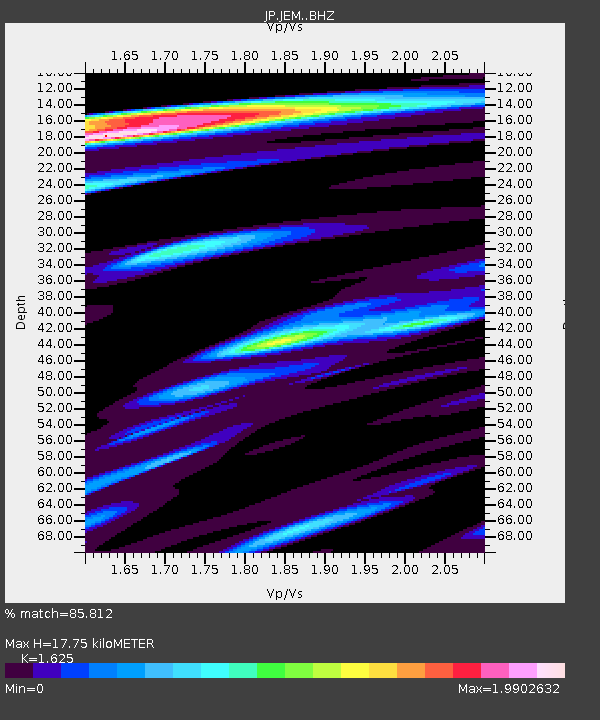
JEM Erimo - Earthquake Result Viewer
| Earthquake location: |
Southern Alaska |
| Earthquake latitude/longitude: |
59.7/-153.5 |
| Earthquake time(UTC): |
2016/01/24 (024) 10:30:30 GMT |
| Earthquake Depth: |
128 km |
| Earthquake Magnitude: |
7.1 MWW, 6.4 ML |
| Earthquake Catalog/Contributor: |
NEIC PDE/NEIC COMCAT |
|
| Network: |
JP Japan Meteorological Agency Seismic Network |
| Station: |
JEM Erimo |
| Lat/Lon: |
42.02 N/143.15 E |
| Elevation: |
40 m |
|
| Distance: |
41.9 deg |
| Az: |
274.382 deg |
| Baz: |
42.79 deg |
| Ray Param: |
0.0730385 |
| Estimated Moho Depth: |
17.75 km |
| Estimated Crust Vp/Vs: |
1.62 |
| Assumed Crust Vp: |
6.461 km/s |
| Estimated Crust Vs: |
3.976 km/s |
| Estimated Crust Poisson's Ratio: |
0.20 |
|
| Radial Match: |
85.812 % |
| Radial Bump: |
400 |
| Transverse Match: |
72.9262 % |
| Transverse Bump: |
400 |
| SOD ConfigId: |
7422571 |
| Insert Time: |
2019-04-21 19:42:11.697 +0000 |
| GWidth: |
2.5 |
| Max Bumps: |
400 |
| Tol: |
0.001 |
|

Signal To Noise
| Channel | StoN | STA | LTA |
| JP:JEM: :BHZ:20160124T10:37:37.899987Z | 27.390306 | 1.530398E-5 | 5.587371E-7 |
| JP:JEM: :BHN:20160124T10:37:37.899987Z | 16.36777 | 7.900683E-6 | 4.826976E-7 |
| JP:JEM: :BHE:20160124T10:37:37.899987Z | 18.06217 | 9.970457E-6 | 5.520077E-7 |
| Arrivals |
| Ps | 1.8 SECOND |
| PpPs | 6.7 SECOND |
| PsPs/PpSs | 8.5 SECOND |


