You are here: Home > Network List > LD - Lamont-Doherty Cooperative Seismographic Network Stations List
> Station MIDE Milford, DE, USA > Earthquake Result Viewer
MIDE Milford, DE, USA - Earthquake Result Viewer
| Earthquake location: |
Near Coast Of Ecuador |
| Earthquake latitude/longitude: |
0.4/-79.9 |
| Earthquake time(UTC): |
2016/04/16 (107) 23:58:37 GMT |
| Earthquake Depth: |
19 km |
| Earthquake Magnitude: |
7.8 MWW, 7.4 MI |
| Earthquake Catalog/Contributor: |
NEIC PDE/NEIC COMCAT |
|
| Network: |
LD Lamont-Doherty Cooperative Seismographic Network |
| Station: |
MIDE Milford, DE, USA |
| Lat/Lon: |
38.88 N/75.33 W |
| Elevation: |
5.0 m |
|
| Distance: |
38.6 deg |
| Az: |
5.782 deg |
| Baz: |
187.416 deg |
| Ray Param: |
0.07547026 |
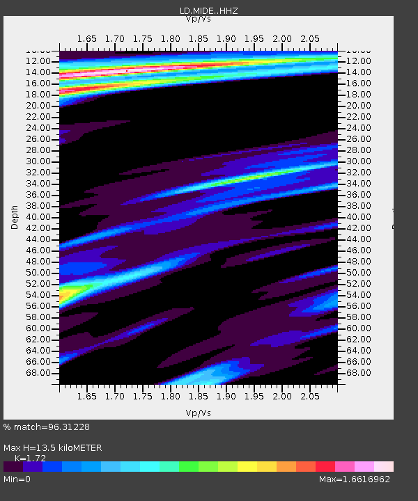
| Estimated Moho Depth: |
13.5 km |
| Estimated Crust Vp/Vs: |
1.72 |
| Assumed Crust Vp: |
6.287 km/s |
| Estimated Crust Vs: |
3.656 km/s |
| Estimated Crust Poisson's Ratio: |
0.24 |
|
| Radial Match: |
96.31228 % |
| Radial Bump: |
298 |
| Transverse Match: |
81.00654 % |
| Transverse Bump: |
400 |
| SOD ConfigId: |
7422571 |
| Insert Time: |
2019-04-22 08:02:36.042 +0000 |
| GWidth: |
2.5 |
| Max Bumps: |
400 |
| Tol: |
0.001 |
|
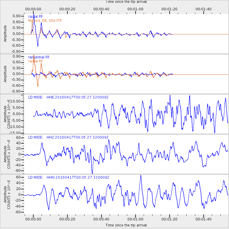
Signal To Noise
| Channel | StoN | STA | LTA |
| LD:MIDE: :HHZ:20160417T00:05:27.320009Z | 9.610731 | 1.0392601E-5 | 1.0813538E-6 |
| LD:MIDE: :HHN:20160417T00:05:27.320009Z | 1.8116302 | 2.7380545E-6 | 1.5113761E-6 |
| LD:MIDE: :HHE:20160417T00:05:27.320009Z | 0.6370114 | 9.179678E-7 | 1.441054E-6 |
| Arrivals |
| Ps | 1.7 SECOND |
| PpPs | 5.4 SECOND |
| PsPs/PpSs | 7.1 SECOND |


