
Station LD MIDE - Milford, DE, USA
Network: LD - Lamont-Doherty Cooperative Seismographic Network
Nearby stations (2 deg radius)
| Station | Name | (Lat, Lon) | Start / End | Elevation |
| MIDE | Milford, DE, USA | (38.88, -75.33) | 2016-02-01 / 2016-10-26 | 5.0 m |
| Crust2 Type: | T7,Margin /shield transition, 3.5 km seds. |
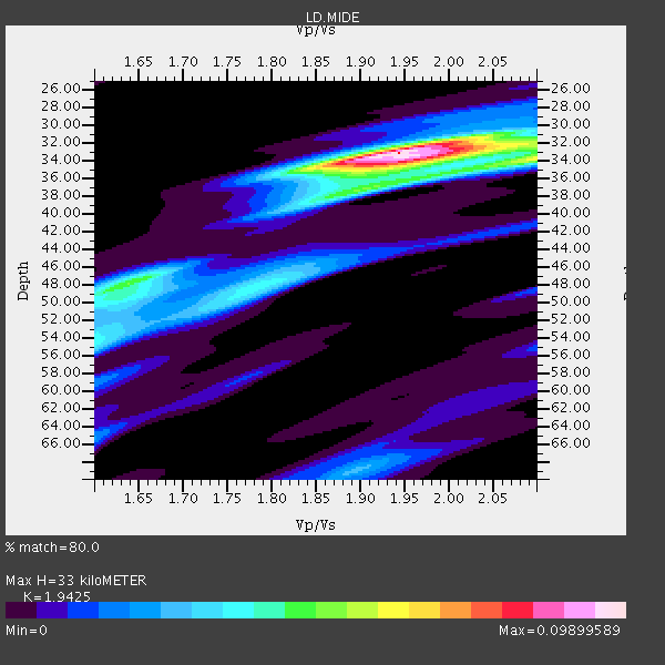
| Thickness Estimate: | 33 km |
| Thickness StdDev: | 8.0 km |
| Vp/Vs Estimate: | 1.94 |
| Vp/Vs StdDev: | 0.13 |
| Vs Estimate: | 3.237 km/s |
| Poisson's Ratio: | 0.32 |
| Peak Value: | 0.10 |
| Assumed Vp: | 6.287 km/s |
| Ps Weight: | 0.33333334 |
| PpPs Weight: | 0.33333334 |
| PsPs Weight: | 0.33333328 |
| Residual Complexity: | 0.627 |
| Nearby stations H: | 30 km +- 3.5 km |
| (2.0 deg) Vp/Vs: | 2.02 +- 0.11 |
3 with match > 90% ( 30.0 %) and 5 with match > 80% ( 50.0 %) out of 10.
Download stack as xyz text file.
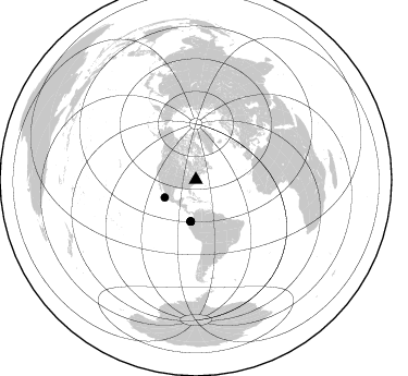
Azimuth Distribution of Events:
Prior Results for this Station
| Study | Thickness | Vp/Vs | Vp | Vs | Poissons Ratio | Extra |
| EARS | 33 km | 1.94 | 6.287 km/s | 3.237 km/s | 0.32 | |
| Crust2.0 | 32 km | 1.79 | 6.287 km/s | 3.506 km/s | 0.27 | T7,Margin /shield transition, 3.5 km seds. |
| Global Maxima | 33 km | 1.94 | 6.287 km/s | 3.237 km/s | 0.32 | amp=0.09899589 |
| Local Maxima 1 | 34 km | 2.10 | 6.287 km/s | 2.998 km/s | 0.35 | amp=0.06122268 |
| Local Maxima 2 | 34 km | 1.97 | 6.287 km/s | 3.2 km/s | 0.33 | amp=0.0476773 |
| Local Maxima 3 | 48 km | 1.63 | 6.287 km/s | 3.857 km/s | 0.20 | amp=0.046076242 |
| Local Maxima 4 | 48 km | 1.79 | 6.287 km/s | 3.522 km/s | 0.27 | amp=0.035813 |
| Predicted Arrivals for vertical incidence (zero ray parameter) | |
| Ps | 4.95 SECOND |
| PpPs | 15.44 SECOND |
| PsPs/PpSs | 20.39 SECOND |
Events Processed for this Station
Download zip of receiver functions as SAC
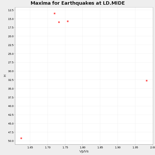
Plot maxima for each earthquake.
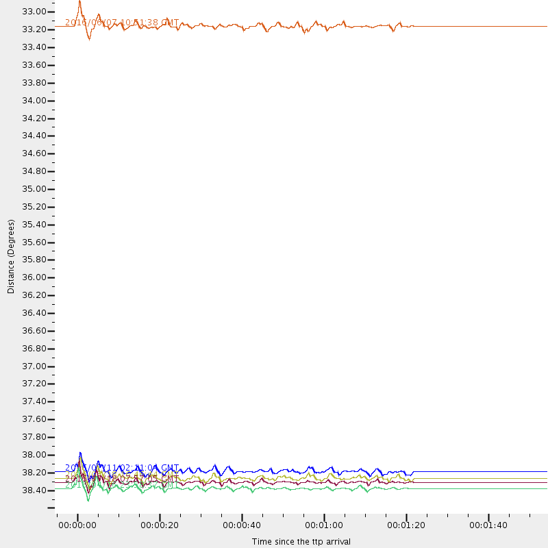
Events Used in the Stack
(5 events)| Radial Match | Distance | Baz | FERegion | Time | Lat/Lon | Depth | Magnitude |
| 96.31228 | 38.6 deg | 187.416 deg | Near Coast Of Ecuador | 2016/04/16 23:58:37 GMT | (0.4, -79.9) | 19 km | 7.8 MWW, 7.4 MI |
| 91.930954 | 38.5 deg | 187.145 deg | Near Coast Of Ecuador | 2016/05/18 07:57:05 GMT | (0.4, -79.8) | 32 km | 6.7 MWP, 6.7 MWW, 6.7 MI |
| 90.36819 | 38.4 deg | 186.952 deg | Near Coast Of Ecuador | 2016/05/18 16:46:44 GMT | (0.5, -79.6) | 31 km | 6.8 MO |
| 86.89213 | 33.0 deg | 240.297 deg | Off Coast Of Jalisco, Mexico | 2016/06/07 10:51:38 GMT | (18.4, -105.2) | 10 km | 6.2 MWP |
| 85.12925 | 38.3 deg | 187.001 deg | Near Coast Of Ecuador | 2016/07/11 02:11:04 GMT | (0.6, -79.7) | 19 km | 6.3 MWW, 6.3 MWC, 6.3 MWB |
Losers
(5 events)| Radial Match | Distance | Baz | FERegion | Time | Lat/Lon | Depth | Magnitude | Reason |
| 76.53854 | 38.3 deg | 186.976 deg | Near Coast Of Ecuador | 2016/07/11 02:01:09 GMT | (0.6, -79.6) | 14 km | 5.8 MWW, 5.7 MWB, 5.9 MWC | |
| 72.73461 | 65.6 deg | 317.335 deg | Andreanof Islands, Aleutian Is. | 2016/03/19 01:35:12 GMT | (51.5, -174.2) | 17 km | 6.0 MWW, 5.5 ML, 5.8 MWB | |
| 67.50903 | 64.8 deg | 175.35 deg | Near Coast Of Northern Chile | 2016/07/25 17:26:49 GMT | (-26.1, -70.6) | 68 km | 6.2 MB | |
| 57.371525 | 75.8 deg | 329.532 deg | Near East Coast Of Kamchatka | 2016/04/14 03:06:09 GMT | (53.9, 160.7) | 36 km | 5.8 MWW, 5.7 MWB, 5.8 MWC | |
| 54.828495 | 72.5 deg | 175.725 deg | Chile-Argentina Border Region | 2016/04/14 09:38:44 GMT | (-33.9, -70.4) | 112 km | 5.5 MB |

