You are here: Home > Network List > GS - US Geological Survey Networks Stations List
> Station OK041 County Line and E0380 Rds, Cleo Springs, OK, USA > Earthquake Result Viewer
OK041 County Line and E0380 Rds, Cleo Springs, OK, USA - Earthquake Result Viewer
| Earthquake location: |
Near Coast Of Ecuador |
| Earthquake latitude/longitude: |
0.6/-80.3 |
| Earthquake time(UTC): |
2016/04/20 (111) 08:33:48 GMT |
| Earthquake Depth: |
16 km |
| Earthquake Magnitude: |
6.1 MO |
| Earthquake Catalog/Contributor: |
NEIC PDE/NEIC ALERT |
|
| Network: |
GS US Geological Survey Networks |
| Station: |
OK041 County Line and E0380 Rds, Cleo Springs, OK, USA |
| Lat/Lon: |
36.47 N/98.53 W |
| Elevation: |
445 m |
|
| Distance: |
39.5 deg |
| Az: |
336.588 deg |
| Baz: |
150.469 deg |
| Ray Param: |
0.07493403 |
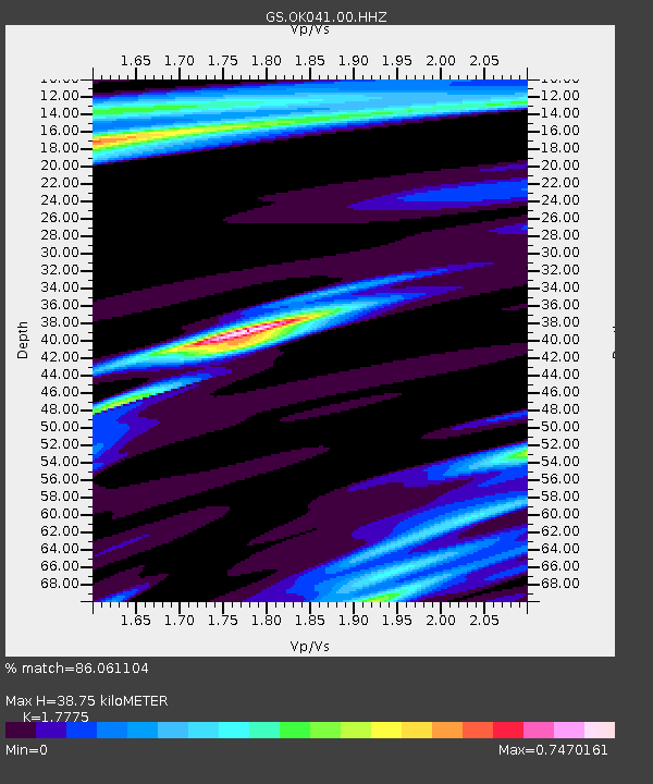
| Estimated Moho Depth: |
38.75 km |
| Estimated Crust Vp/Vs: |
1.78 |
| Assumed Crust Vp: |
6.426 km/s |
| Estimated Crust Vs: |
3.615 km/s |
| Estimated Crust Poisson's Ratio: |
0.27 |
|
| Radial Match: |
86.061104 % |
| Radial Bump: |
400 |
| Transverse Match: |
41.341984 % |
| Transverse Bump: |
400 |
| SOD ConfigId: |
7422571 |
| Insert Time: |
2019-04-22 09:44:49.132 +0000 |
| GWidth: |
2.5 |
| Max Bumps: |
400 |
| Tol: |
0.001 |
|

Signal To Noise
| Channel | StoN | STA | LTA |
| GS:OK041:00:HHZ:20160420T08:40:46.424988Z | 3.776236 | 7.6276643E-7 | 2.0199118E-7 |
| GS:OK041:00:HH1:20160420T08:40:46.424988Z | 1.8119975 | 3.9867763E-7 | 2.2002105E-7 |
| GS:OK041:00:HH2:20160420T08:40:46.424988Z | 1.5123061 | 5.6456634E-7 | 3.733149E-7 |
| Arrivals |
| Ps | 5.0 SECOND |
| PpPs | 16 SECOND |
| PsPs/PpSs | 21 SECOND |


