
Station GS OK041 - County Line and E0380 Rds, Cleo Springs, OK, USA
Network: GS - US Geological Survey Networks
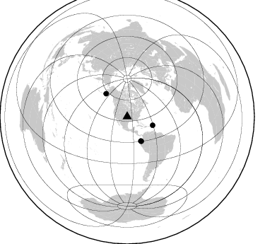
Nearby stations (2 deg radius)
| Station | Name | (Lat, Lon) | Start / End | Elevation |
| OK041 | County Line and E0380 Rds, Cleo Springs, OK, USA | (36.47, -98.53) | 2016-02-20 / 2599-12-31 | 445 m |
| Crust2 Type: | D8,thick Platform 3 km seds. |
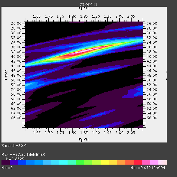
| Thickness Estimate: | 37 km |
| Thickness StdDev: | 1.7 km |
| Vp/Vs Estimate: | 1.85 |
| Vp/Vs StdDev: | 0.05 |
| Vs Estimate: | 3.469 km/s |
| Poisson's Ratio: | 0.29 |
| Peak Value: | 0.05 |
| Assumed Vp: | 6.426 km/s |
| Ps Weight: | 0.33333334 |
| PpPs Weight: | 0.33333334 |
| PsPs Weight: | 0.33333328 |
| Residual Complexity: | 0.524 |
| Nearby stations H: | +- |
| (2.0 deg) Vp/Vs: | +- |
2 with match > 90% ( 15.384615 %) and 5 with match > 80% ( 38.46154 %) out of 13.
Download stack as xyz text file.
Azimuth Distribution of Events:
Prior Results for this Station
| Study | Thickness | Vp/Vs | Vp | Vs | Poissons Ratio | Extra |
| EARS | 37 km | 1.85 | 6.426 km/s | 3.469 km/s | 0.29 | |
| Crust2.0 | 46 km | 1.78 | 6.426 km/s | 3.613 km/s | 0.27 | D8,thick Platform 3 km seds. |
| Global Maxima | 37 km | 1.85 | 6.426 km/s | 3.469 km/s | 0.29 | amp=0.052129004 |
| Local Maxima 1 | 40 km | 1.77 | 6.426 km/s | 3.636 km/s | 0.26 | amp=0.03181429 |
| Local Maxima 2 | 34 km | 2.00 | 6.426 km/s | 3.213 km/s | 0.33 | amp=0.022403864 |
| Local Maxima 3 | 43 km | 1.62 | 6.426 km/s | 3.961 km/s | 0.19 | amp=0.014811432 |
| Local Maxima 4 | 52 km | 1.60 | 6.426 km/s | 4.016 km/s | 0.18 | amp=0.013961901 |
| Predicted Arrivals for vertical incidence (zero ray parameter) | |
| Ps | 4.94 SECOND |
| PpPs | 16.54 SECOND |
| PsPs/PpSs | 21.48 SECOND |
Events Processed for this Station
Download zip of receiver functions as SAC
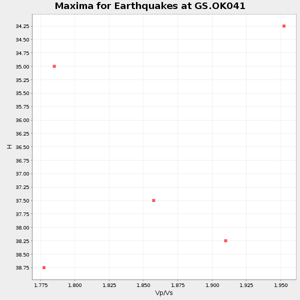
Plot maxima for each earthquake.
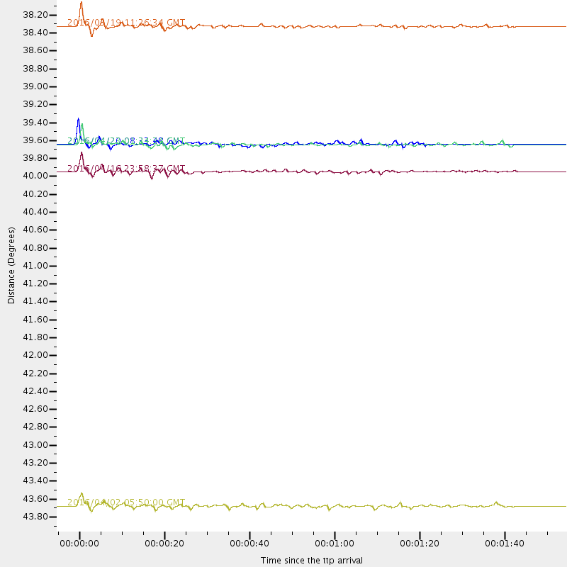
Events Used in the Stack
(5 events)| Radial Match | Distance | Baz | FERegion | Time | Lat/Lon | Depth | Magnitude |
| 96.647934 | 39.8 deg | 150.154 deg | Near Coast Of Ecuador | 2016/04/16 23:58:37 GMT | (0.4, -79.9) | 19 km | 7.8 MWW, 7.4 MI |
| 93.07404 | 38.0 deg | 108.68 deg | Leeward Islands | 2016/03/19 11:26:34 GMT | (18.0, -60.7) | 32 km | 6.0 MWW, 5.9 MWB |
| 89.170555 | 44.0 deg | 317.329 deg | Alaska Peninsula | 2016/04/02 05:50:00 GMT | (57.0, -158.0) | 10 km | 6.2 MWP, 6.4 MI |
| 86.061104 | 39.5 deg | 150.469 deg | Near Coast Of Ecuador | 2016/04/20 08:33:48 GMT | (0.6, -80.3) | 16 km | 6.1 MO |
| 80.18524 | 39.5 deg | 150.486 deg | Near Coast Of Ecuador | 2016/04/23 01:24:34 GMT | (0.6, -80.3) | 10 km | 5.8 MWP |
Losers
(8 events)| Radial Match | Distance | Baz | FERegion | Time | Lat/Lon | Depth | Magnitude | Reason |
| 64.42613 | 97.0 deg | 319.947 deg | Kyushu, Japan | 2016/04/15 16:45:56 GMT | (32.9, 130.8) | 10 km | 5.7 MB | |
| 50.405174 | 93.1 deg | 242.948 deg | Tonga Islands Region | 2016/04/17 07:31:03 GMT | (-23.6, -174.3) | 35 km | 5.8 MB | |
| 49.909397 | 44.6 deg | 110.098 deg | North Atlantic Ocean | 2016/04/20 10:51:39 GMT | (13.2, -55.9) | 10 km | 5.8 MB | |
| 45.33627 | 39.6 deg | 150.202 deg | Near Coast Of Ecuador | 2016/04/19 22:22:26 GMT | (0.6, -80.1) | 15 km | 5.5 MB | |
| 40.816544 | 68.2 deg | 152.399 deg | Northern Chile | 2016/04/16 06:05:22 GMT | (-26.5, -69.9) | 59 km | 5.3 Mww | |
| 40.634995 | 95.9 deg | 304.863 deg | Volcano Islands, Japan Region | 2016/02/21 21:26:23 GMT | (23.6, 144.3) | 30 km | 5.6 MB | |
| 40.618866 | 53.9 deg | 311.591 deg | Andreanof Islands, Aleutian Is. | 2016/03/13 04:19:25 GMT | (51.5, -173.9) | 10 km | 5.5 MWC, 4.7 ML, 5.4 MB, 5.5 MWC | |
| 35.035366 | 54.1 deg | 311.619 deg | Andreanof Islands, Aleutian Is. | 2016/03/19 01:35:12 GMT | (51.5, -174.2) | 17 km | 6.0 MWW, 5.5 ML, 5.8 MWB |

