You are here: Home > Network List > NE - New England Seismic Network Stations List
> Station ORNO Orno, ME, USA > Earthquake Result Viewer
ORNO Orno, ME, USA - Earthquake Result Viewer
| Earthquake location: |
Northern East Pacific Rise |
| Earthquake latitude/longitude: |
10.3/-103.8 |
| Earthquake time(UTC): |
2016/04/29 (120) 01:33:38 GMT |
| Earthquake Depth: |
10 km |
| Earthquake Magnitude: |
6.8 MWP, 6.9 MI |
| Earthquake Catalog/Contributor: |
NEIC PDE/NEIC COMCAT |
|
| Network: |
NE New England Seismic Network |
| Station: |
ORNO Orno, ME, USA |
| Lat/Lon: |
44.90 N/68.66 W |
| Elevation: |
40 m |
|
| Distance: |
45.8 deg |
| Az: |
34.721 deg |
| Baz: |
232.08 deg |
| Ray Param: |
0.071014434 |
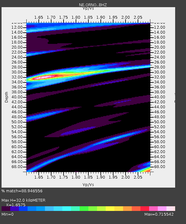
| Estimated Moho Depth: |
32.0 km |
| Estimated Crust Vp/Vs: |
1.66 |
| Assumed Crust Vp: |
6.419 km/s |
| Estimated Crust Vs: |
3.873 km/s |
| Estimated Crust Poisson's Ratio: |
0.21 |
|
| Radial Match: |
88.946556 % |
| Radial Bump: |
320 |
| Transverse Match: |
61.55251 % |
| Transverse Bump: |
400 |
| SOD ConfigId: |
7422571 |
| Insert Time: |
2019-04-22 12:09:04.547 +0000 |
| GWidth: |
2.5 |
| Max Bumps: |
400 |
| Tol: |
0.001 |
|

Signal To Noise
| Channel | StoN | STA | LTA |
| NE:ORNO: :BHZ:20160429T01:41:29.874993Z | 3.9405177 | 1.0579835E-6 | 2.6848846E-7 |
| NE:ORNO: :BHN:20160429T01:41:29.874993Z | 1.3335912 | 3.998493E-7 | 2.9982897E-7 |
| NE:ORNO: :BHE:20160429T01:41:29.874993Z | 3.4881728 | 6.2514624E-7 | 1.7921883E-7 |
| Arrivals |
| Ps | 3.5 SECOND |
| PpPs | 12 SECOND |
| PsPs/PpSs | 16 SECOND |


