
Station NE ORNO - Orno, ME, USA
Network: NE - New England Seismic Network
Nearby stations (2 deg radius)
| Station | Name | (Lat, Lon) | Start / End | Elevation |
| ORNO | Orno, ME, USA | (44.90, -68.66) | 2009-03-06 / 2599-12-31 | 40 m |
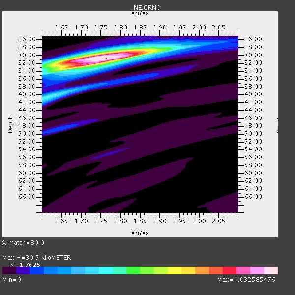
| Crust2 Type: | Q2,orogen/39km no ice, Appalachians, North Andes, 0.5 km seds. |
| Thickness Estimate: | 30 km |
| Thickness StdDev: | 1.3 km |
| Vp/Vs Estimate: | 1.76 |
| Vp/Vs StdDev: | 0.03 |
| Vs Estimate: | 3.642 km/s |
| Poisson's Ratio: | 0.26 |
| Peak Value: | 0.03 |
| Assumed Vp: | 6.419 km/s |
| Ps Weight: | 0.33333334 |
| PpPs Weight: | 0.33333334 |
| PsPs Weight: | 0.33333328 |
| Residual Complexity: | 0.417 |
| Nearby stations H: | +- |
| (2.0 deg) Vp/Vs: | +- |
9 with match > 90% ( 20.0 %) and 14 with match > 80% ( 31.11111 %) out of 45.
Download stack as xyz text file.
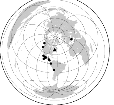
Azimuth Distribution of Events:
Prior Results for this Station
| Study | Thickness | Vp/Vs | Vp | Vs | Poissons Ratio | Extra |
| EARS | 30 km | 1.76 | 6.419 km/s | 3.642 km/s | 0.26 | |
| Crust2.0 | 39 km | 1.75 | 6.419 km/s | 3.659 km/s | 0.26 | Q2,orogen/39km no ice, Appalachians, North Andes, 0.5 km seds. |
| Global Maxima | 30 km | 1.76 | 6.419 km/s | 3.642 km/s | 0.26 | amp=0.032585476 |
| Local Maxima 1 | 32 km | 1.70 | 6.419 km/s | 3.776 km/s | 0.24 | amp=0.016080469 |
| Local Maxima 2 | 30 km | 1.75 | 6.419 km/s | 3.663 km/s | 0.26 | amp=0.012570388 |
| Local Maxima 3 | 41 km | 1.60 | 6.419 km/s | 4.006 km/s | 0.18 | amp=0.011874023 |
| Local Maxima 4 | 38 km | 1.69 | 6.419 km/s | 3.798 km/s | 0.23 | amp=0.004446636 |
| Predicted Arrivals for vertical incidence (zero ray parameter) | |
| Ps | 3.62 SECOND |
| PpPs | 13.13 SECOND |
| PsPs/PpSs | 16.75 SECOND |
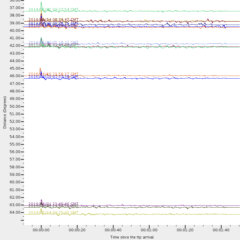
Events Processed for this Station
Download zip of receiver functions as SAC
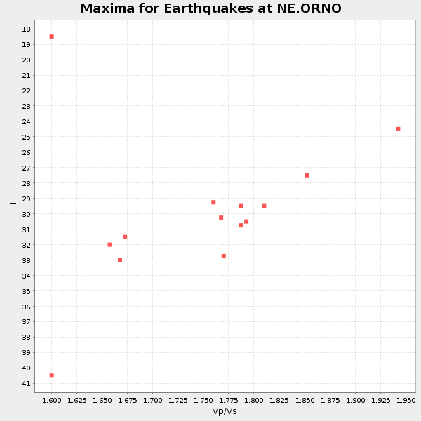
Plot maxima for each earthquake.
Events Used in the Stack
(14 events)| Radial Match | Distance | Baz | FERegion | Time | Lat/Lon | Depth | Magnitude |
| 98.436226 | 64.3 deg | 182.255 deg | Near Coast Of Northern Chile | 2014/04/01 23:46:46 GMT | (-19.6, -70.8) | 20 km | 8.2 MWW, 8.0 MI, 8.1 MWC |
| 98.3366 | 45.5 deg | 195.925 deg | Near Coast Of Ecuador | 2016/04/16 23:58:37 GMT | (0.4, -79.9) | 19 km | 7.8 MWW, 7.4 MI |
| 97.70671 | 41.2 deg | 304.51 deg | Queen Charlotte Islands Region | 2012/10/28 03:04:08 GMT | (52.8, -132.1) | 14 km | 6.5 MB, 7.5 MS, 7.8 MW, 7.8 MW |
| 93.960335 | 38.3 deg | 234.662 deg | Guerrero, Mexico | 2014/05/08 17:00:17 GMT | (17.4, -100.7) | 24 km | 6.4 MWW, 6.8 MI |
| 92.49805 | 37.5 deg | 207.561 deg | Costa Rica | 2012/10/24 00:45:32 GMT | (10.1, -85.3) | 17 km | 6.0 MB, 6.2 MS, 6.5 MW, 6.4 MW |
| 92.29946 | 36.1 deg | 212.692 deg | Near Coast Of Nicaragua | 2014/03/02 09:37:54 GMT | (12.6, -87.7) | 60 km | 6.2 MWW, 6.2 MWB, 6.2 MWC, 6.3 MWC |
| 92.06824 | 40.9 deg | 284.869 deg | Off Coast Of Northern California | 2014/03/10 05:18:13 GMT | (40.8, -125.1) | 17 km | 6.8 MW, 6.8 MWR, 6.9 MWW, 6.9 MWB, 7.0 MI, 7.0 MWC |
| 91.85068 | 65.5 deg | 56.933 deg | Aegean Sea | 2014/05/24 09:25:03 GMT | (40.3, 25.5) | 10 km | 6.4 MWP, 6.4 M |
| 90.899506 | 38.5 deg | 234.663 deg | Guerrero, Mexico | 2014/05/10 07:36:03 GMT | (17.3, -100.8) | 35 km | 6.0 MB |
| 88.946556 | 45.8 deg | 232.08 deg | Northern East Pacific Rise | 2016/04/29 01:33:38 GMT | (10.3, -103.8) | 10 km | 6.8 MWP, 6.9 MI |
| 86.91223 | 64.5 deg | 182.048 deg | Near Coast Of Northern Chile | 2014/03/16 21:16:30 GMT | (-19.9, -70.6) | 20 km | 6.7 MWW, 6.7 MWC, 7.0 MI |
| 83.07164 | 41.4 deg | 243.858 deg | Off Coast Of Jalisco, Mexico | 2014/05/31 11:53:48 GMT | (18.9, -107.4) | 10 km | 6.2 MWP, 6.6 MI |
| 82.54363 | 37.6 deg | 230.683 deg | Near Coast Of Guerrero, Mexico | 2014/05/24 08:24:47 GMT | (16.5, -98.1) | 17 km | 5.7 MWW, 5.6 MWB, 5.7 MWC |
| 81.95304 | 38.1 deg | 230.485 deg | Near Coast Of Guerrero, Mexico | 2014/03/10 00:38:15 GMT | (16.0, -98.3) | 8.4 km | 5.8 MWW, 5.9 MWC, 6.0 MWB |
Losers
(31 events)| Radial Match | Distance | Baz | FERegion | Time | Lat/Lon | Depth | Magnitude | Reason |
| 95.48981 | 65.1 deg | 181.897 deg | Near Coast Of Northern Chile | 2014/04/03 02:43:14 GMT | (-20.5, -70.5) | 31 km | 7.7 MWW, 7.4 MI, 7.7 MWC | |
| 78.29148 | 35.3 deg | 226.987 deg | Chiapas, Mexico | 2014/05/21 10:06:14 GMT | (17.2, -94.9) | 128 km | 5.6 MWP | |
| 77.460106 | 71.8 deg | 57.179 deg | Turkey | 2013/12/28 15:21:04 GMT | (36.0, 31.3) | 41 km | 5.9 MWW, 5.9 MWB, 6.0 MWC | |
| 74.89795 | 71.9 deg | 331.184 deg | Near East Coast Of Kamchatka | 2016/03/20 22:50:20 GMT | (54.3, 162.8) | 31 km | 6.4 MWC, 6.2 MWB, 6.6 MI | |
| 74.67517 | 70.6 deg | 332.15 deg | Near East Coast Of Kamchatka | 2012/11/02 01:52:03 GMT | (55.9, 162.8) | 9.1 km | 5.5 MB, 5.4 MS, 5.5 MW, 5.6 MW | |
| 74.655205 | 39.4 deg | 201.698 deg | South Of Panama | 2014/05/13 06:35:24 GMT | (7.2, -82.3) | 10 km | 6.8 MWP, 6.8 MI | |
| 74.43663 | 64.4 deg | 182.245 deg | Near Coast Of Northern Chile | 2014/03/23 18:20:03 GMT | (-19.7, -70.8) | 35 km | 6.0 MB, 6.2 MWB, 6.2 MWW, 6.3 MWC | |
| 73.96534 | 65.2 deg | 182.143 deg | Near Coast Of Northern Chile | 2014/04/04 01:37:51 GMT | (-20.6, -70.7) | 20 km | 6.1 MWP, 6.1 MWB, 6.1 MWW, 6.3 MWC | |
| 73.11786 | 45.3 deg | 196.431 deg | Near Coast Of Ecuador | 2016/04/20 08:33:48 GMT | (0.6, -80.3) | 16 km | 6.1 MO | |
| 72.91377 | 64.6 deg | 182.302 deg | Near Coast Of Northern Chile | 2014/03/17 05:11:34 GMT | (-20.0, -70.9) | 17 km | 6.2 MWW, 6.2 MWB, 6.5 MWC | |
| 66.83614 | 79.3 deg | 358.488 deg | East Of Lake Baykal, Russia | 2014/05/23 19:42:28 GMT | (56.1, 114.0) | 10 km | 5.6 MB | |
| 66.81852 | 77.4 deg | 181.421 deg | Chile-Argentina Border Region | 2012/10/11 17:22:09 GMT | (-32.9, -70.3) | 82 km | 5.5 MB, 5.5 MW, 5.6 MW | |
| 64.99289 | 45.3 deg | 196.138 deg | Near Coast Of Ecuador | 2016/04/19 22:22:26 GMT | (0.6, -80.1) | 15 km | 5.5 MB | |
| 64.50693 | 49.6 deg | 319.01 deg | Southern Alaska | 2014/05/10 14:16:08 GMT | (60.0, -152.2) | 96 km | 5.8 ML, 5.5 MI, 5.7 MWP | |
| 64.0927 | 90.6 deg | 185.572 deg | Off Coast Of Southern Chile | 2014/03/02 11:14:42 GMT | (-45.8, -76.6) | 23 km | 5.2 MW | |
| 61.32416 | 68.0 deg | 179.916 deg | Northern Chile | 2014/05/16 17:08:32 GMT | (-23.5, -68.6) | 103 km | 5.5 MWR | |
| 61.172016 | 36.6 deg | 221.965 deg | Near Coast Of Chiapas, Mexico | 2016/04/27 12:51:22 GMT | (14.6, -93.0) | 35 km | 5.8 MB | |
| 60.950817 | 36.1 deg | 220.726 deg | Near Coast Of Chiapas, Mexico | 2014/01/11 13:10:51 GMT | (14.6, -92.1) | 78 km | 5.5 MWB, 5.7 MWC | |
| 60.182846 | 66.3 deg | 179.495 deg | Chile-Bolivia Border Region | 2012/10/08 01:50:26 GMT | (-21.7, -68.2) | 122 km | 6.0 MB, 5.7 MW, 5.8 MW | |
| 58.685738 | 53.6 deg | 317.206 deg | Alaska Peninsula | 2016/04/02 05:50:00 GMT | (57.0, -158.0) | 10 km | 6.2 MWP, 6.4 MI | |
| 58.632465 | 36.6 deg | 211.138 deg | Near Coast Of Nicaragua | 2014/03/24 11:24:42 GMT | (11.7, -87.0) | 61 km | 4.5 mb | |
| 58.3537 | 46.3 deg | 196.556 deg | Near Coast Of Ecuador | 2016/04/22 03:03:42 GMT | (-0.3, -80.5) | 10 km | 6.0 MO | |
| 57.386875 | 73.0 deg | 331.935 deg | Near East Coast Of Kamchatka | 2016/04/14 03:06:09 GMT | (53.9, 160.7) | 36 km | 5.8 MWW, 5.7 MWB, 5.8 MWC | |
| 56.757286 | 64.8 deg | 181.913 deg | Near Coast Of Northern Chile | 2014/04/05 05:44:57 GMT | (-20.1, -70.5) | 39 km | 5.3 MW | |
| 54.44541 | 72.7 deg | 332.927 deg | Near East Coast Of Kamchatka | 2014/01/31 16:39:06 GMT | (54.6, 159.7) | 168 km | 5.5 MW | |
| 53.38462 | 78.2 deg | 182.809 deg | Near Coast Of Central Chile | 2014/03/04 10:51:15 GMT | (-33.6, -72.0) | 20 km | 5.7 MWW, 5.7 MWB, 5.8 MWC | |
| 52.71682 | 61.5 deg | 316.367 deg | Fox Islands, Aleutian Islands | 2016/03/27 18:01:30 GMT | (52.2, -168.7) | 16 km | 5.7 MWB | |
| 50.055603 | 95.8 deg | 336.756 deg | Near East Coast Of Honshu, Japan | 2014/05/12 23:35:02 GMT | (35.6, 140.1) | 58 km | 5.0 MW | |
| 47.472816 | 91.2 deg | 31.336 deg | Afghanistan-Tajikistan Bord Reg. | 2016/04/10 10:28:58 GMT | (36.5, 71.2) | 210 km | 6.6 MWB | |
| 44.5971 | 78.0 deg | 331.899 deg | Kuril Islands | 2012/10/16 12:41:25 GMT | (49.6, 156.4) | 81 km | 6.2 MB, 5.6 MW, 5.6 MW | |
| 40.71379 | 62.1 deg | 318.94 deg | Fox Islands, Aleutian Islands | 2014/02/26 21:13:40 GMT | (53.6, -171.8) | 265 km | 6.1 MWW, 5.9 MI, 5.9 ML, 6.1 MWC, 6.1 MWB, 6.2 MWC |

