You are here: Home > Network List > TA - USArray Transportable Network (new EarthScope stations) Stations List
> Station L02F Cave Junction, OR, USA > Earthquake Result Viewer
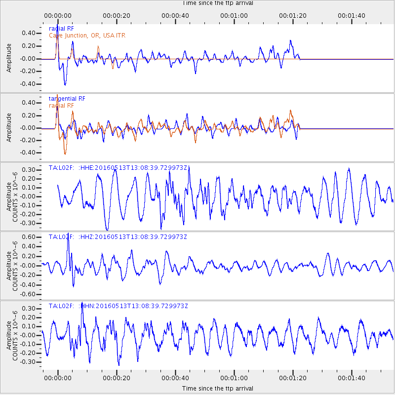
L02F Cave Junction, OR, USA - Earthquake Result Viewer
*The percent match for this event was below the threshold and hence no stack was calculated.
| Earthquake location: |
South Of Fiji Islands |
| Earthquake latitude/longitude: |
-25.5/179.3 |
| Earthquake time(UTC): |
2016/05/13 (134) 12:57:27 GMT |
| Earthquake Depth: |
506 km |
| Earthquake Magnitude: |
5.6 MWW |
| Earthquake Catalog/Contributor: |
NEIC PDE/NEIC COMCAT |
|
| Network: |
TA USArray Transportable Network (new EarthScope stations) |
| Station: |
L02F Cave Junction, OR, USA |
| Lat/Lon: |
42.12 N/123.57 W |
| Elevation: |
440 m |
|
| Distance: |
85.4 deg |
| Az: |
38.796 deg |
| Baz: |
229.57 deg |
| Ray Param: |
$rayparam |
*The percent match for this event was below the threshold and hence was not used in the summary stack. |
|
| Radial Match: |
60.74065 % |
| Radial Bump: |
400 |
| Transverse Match: |
57.975826 % |
| Transverse Bump: |
400 |
| SOD ConfigId: |
7422571 |
| Insert Time: |
2019-04-22 14:03:03.124 +0000 |
| GWidth: |
2.5 |
| Max Bumps: |
400 |
| Tol: |
0.001 |
|
Signal To Noise
| Channel | StoN | STA | LTA |
| TA:L02F: :HHZ:20160513T13:08:39.729973Z | 1.8345832 | 2.2092462E-7 | 1.2042224E-7 |
| TA:L02F: :HHN:20160513T13:08:39.729973Z | 0.8607296 | 7.773932E-8 | 9.031794E-8 |
| TA:L02F: :HHE:20160513T13:08:39.729973Z | 0.84797716 | 1.3144152E-7 | 1.5500598E-7 |
| Arrivals |
| Ps | |
| PpPs | |
| PsPs/PpSs | |


