
Station TA L02F - Cave Junction, OR, USA
Network: TA - USArray Transportable Network (new EarthScope stations)
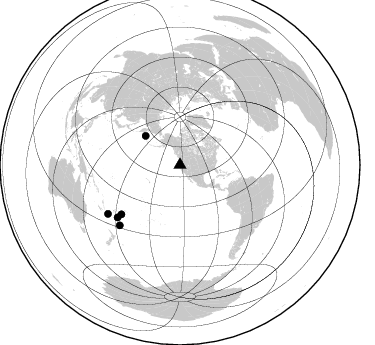
Nearby stations (2 deg radius)
| Station | Name | (Lat, Lon) | Start / End | Elevation |
| L02F | Cave Junction, OR, USA | (42.12, -123.57) | 2016-04-30 / 2016-09-30 | 440 m |
| Crust2 Type: | LC,continental arc, Cordilleras, 1.0 km seds. |
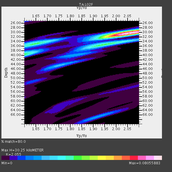
| Thickness Estimate: | 30 km |
| Thickness StdDev: | 0.6 km |
| Vp/Vs Estimate: | 2.06 |
| Vp/Vs StdDev: | 0.03 |
| Vs Estimate: | 3.174 km/s |
| Poisson's Ratio: | 0.34 |
| Peak Value: | 0.08 |
| Assumed Vp: | 6.522 km/s |
| Ps Weight: | 0.33333334 |
| PpPs Weight: | 0.33333334 |
| PsPs Weight: | 0.33333328 |
| Residual Complexity: | 0.440 |
| Nearby stations H: | +- |
| (2.0 deg) Vp/Vs: | +- |
1 with match > 90% ( 2.5 %) and 5 with match > 80% ( 12.5 %) out of 40.
Download stack as xyz text file.
Azimuth Distribution of Events:
Prior Results for this Station
| Study | Thickness | Vp/Vs | Vp | Vs | Poissons Ratio | Extra |
| EARS | 30 km | 2.06 | 6.522 km/s | 3.174 km/s | 0.34 | |
| Crust2.0 | 37 km | 1.77 | 6.522 km/s | 3.676 km/s | 0.27 | LC,continental arc, Cordilleras, 1.0 km seds. |
| Global Maxima | 30 km | 2.06 | 6.522 km/s | 3.174 km/s | 0.34 | amp=0.08055883 |
| Local Maxima 1 | 40 km | 1.60 | 6.522 km/s | 4.076 km/s | 0.18 | amp=0.03551044 |
| Local Maxima 2 | 35 km | 1.60 | 6.522 km/s | 4.076 km/s | 0.18 | amp=0.022400912 |
| Local Maxima 3 | 44 km | 1.75 | 6.522 km/s | 3.716 km/s | 0.26 | amp=0.019984 |
| Local Maxima 4 | 67 km | 1.91 | 6.522 km/s | 3.406 km/s | 0.31 | amp=0.017868103 |
| Predicted Arrivals for vertical incidence (zero ray parameter) | |
| Ps | 4.89 SECOND |
| PpPs | 14.17 SECOND |
| PsPs/PpSs | 19.06 SECOND |
Events Processed for this Station
Download zip of receiver functions as SAC
Plot maxima for each earthquake.
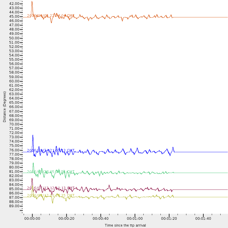
Events Used in the Stack
(5 events)| Radial Match | Distance | Baz | FERegion | Time | Lat/Lon | Depth | Magnitude |
| 90.44203 | 86.9 deg | 235.85 deg | Southeast Of Loyalty Islands | 2016/08/12 01:26:35 GMT | (-22.5, 173.1) | 10 km | 7.2 MWW, 7.6 MI |
| 87.6015 | 81.3 deg | 229.91 deg | South Of Fiji Islands | 2016/05/28 05:38:51 GMT | (-22.0, -178.2) | 417 km | 6.6 MO |
| 82.00102 | 76.4 deg | 229.916 deg | Tonga Islands | 2016/09/24 21:07:13 GMT | (-18.1, -175.0) | 179 km | 6.3 MO |
| 81.33919 | 45.1 deg | 310.034 deg | Komandorskiye Ostrova Region | 2016/09/05 22:54:04 GMT | (54.3, 168.6) | 10 km | 5.7 MB |
| 80.68777 | 85.1 deg | 224.977 deg | Kermadec Islands Region | 2016/07/13 12:11:13 GMT | (-28.0, -176.4) | 12 km | 6.3 MWB |
Losers
(35 events)| Radial Match | Distance | Baz | FERegion | Time | Lat/Lon | Depth | Magnitude | Reason |
| 97.43911 | 78.5 deg | 284.467 deg | Mariana Islands | 2016/07/29 21:18:25 GMT | (18.5, 145.5) | 212 km | 7.7 MWW, 7.7 MWB, 7.7 MI | |
| 91.367744 | 88.3 deg | 263.816 deg | New Ireland Region, P.N.G. | 2016/06/21 17:12:08 GMT | (-3.5, 151.9) | 365 km | 6.3 MWB | |
| 79.73889 | 86.8 deg | 241.092 deg | Vanuatu Islands | 2016/07/20 15:13:16 GMT | (-18.9, 169.0) | 164 km | 6.0 MO | |
| 78.38792 | 57.2 deg | 124.411 deg | Near Coast Of Ecuador | 2016/05/18 16:46:44 GMT | (0.5, -79.6) | 31 km | 6.8 MO | |
| 77.880394 | 61.4 deg | 313.371 deg | Sakhalin, Russia | 2016/08/14 11:15:14 GMT | (50.4, 142.3) | 5.8 km | 5.7 MWW, 5.7 MWB, 5.8 MWC | |
| 75.85861 | 87.7 deg | 263.02 deg | New Ireland Region, P.N.G. | 2016/08/31 03:11:36 GMT | (-3.7, 152.8) | 499 km | 6.7 MO | |
| 75.46346 | 87.0 deg | 30.381 deg | Central Italy | 2016/08/24 01:36:33 GMT | (42.7, 13.2) | 10 km | 6.2 MWP | |
| 74.89523 | 79.7 deg | 231.347 deg | Fiji Islands Region | 2016/09/24 21:28:42 GMT | (-19.8, -178.3) | 594 km | 6.8 MO | |
| 73.6948 | 83.6 deg | 133.795 deg | Near Coast Of Northern Chile | 2016/07/25 17:26:49 GMT | (-26.1, -70.6) | 68 km | 6.2 MB | |
| 71.87214 | 57.2 deg | 124.555 deg | Near Coast Of Ecuador | 2016/05/18 07:57:05 GMT | (0.4, -79.8) | 32 km | 6.7 MWP, 6.7 MWW, 6.7 MI | |
| 71.799835 | 84.0 deg | 301.763 deg | Ryukyu Islands, Japan | 2016/09/26 05:19:58 GMT | (27.5, 128.6) | 40 km | 6.0 MB | |
| 70.04051 | 76.8 deg | 291.627 deg | Volcano Islands, Japan Region | 2016/08/04 16:24:33 GMT | (24.9, 142.0) | 510 km | 6.3 MWW, 6.2 MWC, 6.3 MWB, 6.3 MWC | |
| 69.3593 | 85.9 deg | 244.138 deg | Vanuatu Islands | 2016/06/30 11:30:34 GMT | (-16.1, 167.4) | 40 km | 5.8 MB | |
| 69.11674 | 87.7 deg | 224.765 deg | Kermadec Islands, New Zealand | 2016/06/01 15:37:23 GMT | (-30.2, -178.0) | 44 km | 5.5 MWC, 5.5 MWC | |
| 68.4698 | 66.8 deg | 79.894 deg | Northern Mid-Atlantic Ridge | 2016/06/21 16:26:34 GMT | (22.7, -45.1) | 10 km | 6.1 MWB | |
| 68.31856 | 83.9 deg | 301.892 deg | Ryukyu Islands, Japan | 2016/05/27 03:46:51 GMT | (27.7, 128.6) | 10 km | 5.5 MB | |
| 68.21586 | 89.2 deg | 304.338 deg | Taiwan Region | 2016/05/31 05:23:47 GMT | (25.6, 122.5) | 243 km | 6.1 MO | |
| 67.502686 | 73.2 deg | 230.661 deg | Tonga Islands | 2016/07/23 20:09:19 GMT | (-15.1, -173.6) | 10 km | 5.7 MB | |
| 67.28557 | 63.6 deg | 126.173 deg | Northern Peru | 2016/09/10 10:08:20 GMT | (-5.6, -77.0) | 114 km | 6.0 MB | |
| 65.82399 | 73.0 deg | 230.34 deg | Tonga Islands | 2016/07/10 13:44:41 GMT | (-15.1, -173.2) | 10 km | 5.5 MB, 5.8 MWB | |
| 64.67632 | 86.9 deg | 254.583 deg | Solomon Islands | 2016/09/14 07:24:59 GMT | (-9.4, 159.1) | 10 km | 6.0 MWB | |
| 64.24709 | 87.9 deg | 240.381 deg | Loyalty Islands | 2016/06/20 03:50:55 GMT | (-20.2, 168.8) | 15 km | 6.0 MWW, 5.8 MWB, 5.9 MWC, 6.0 MWC | |
| 63.767582 | 39.1 deg | 304.015 deg | Rat Islands, Aleutian Islands | 2016/08/14 16:28:55 GMT | (51.5, 179.6) | 65 km | 5.6 MWB, 5.5 MI, 5.6 ML | |
| 63.748096 | 84.1 deg | 130.068 deg | Chile-Argentina Border Region | 2016/06/18 17:29:44 GMT | (-24.2, -67.1) | 167 km | 5.5 MB | |
| 63.317165 | 86.9 deg | 241.327 deg | Vanuatu Islands | 2016/06/14 13:49:22 GMT | (-18.8, 168.8) | 111 km | 6.2 MWW, 6.2 MWB | |
| 63.00311 | 32.2 deg | 141.558 deg | Off Coast Of Guerrero, Mexico | 2016/07/23 08:52:02 GMT | (14.9, -103.5) | 45 km | 5.5 MB | |
| 62.94148 | 43.1 deg | 121.73 deg | Near Coast Of Nicaragua | 2016/06/10 03:25:22 GMT | (12.8, -87.0) | 10 km | 6.1 MWP | |
| 61.03881 | 60.2 deg | 308.879 deg | Northwest Of Kuril Islands | 2016/07/23 01:00:21 GMT | (47.7, 147.0) | 407 km | 5.7 MB | |
| 60.74065 | 85.4 deg | 229.57 deg | South Of Fiji Islands | 2016/05/13 12:57:27 GMT | (-25.5, 179.3) | 506 km | 5.6 MWW | |
| 57.309208 | 66.2 deg | 303.456 deg | Off East Coast Of Honshu, Japan | 2016/08/20 09:01:26 GMT | (40.4, 143.7) | 10 km | 6.0 MO | |
| 57.261692 | 90.2 deg | 304.097 deg | Taiwan | 2016/05/12 03:17:16 GMT | (24.7, 122.0) | 10 km | 5.6 MB | |
| 56.288185 | 87.8 deg | 224.659 deg | Kermadec Islands, New Zealand | 2016/05/30 07:14:16 GMT | (-30.4, -177.9) | 32 km | 5.7 MWB | |
| 54.4619 | 75.9 deg | 298.507 deg | Southeast Of Honshu, Japan | 2016/08/25 17:04:43 GMT | (30.6, 137.8) | 456 km | 5.9 MWW, 5.9 MWB | |
| 50.893703 | 33.8 deg | 131.146 deg | Oaxaca, Mexico | 2016/05/08 07:34:02 GMT | (16.6, -97.7) | 24 km | 5.9 MB | |
| 29.015059 | 74.5 deg | 128.484 deg | Southern Peru | 2016/08/15 02:59:00 GMT | (-15.7, -72.0) | 20 km | 5.5 mwb |

