You are here: Home > Network List > TA - USArray Transportable Network (new EarthScope stations) Stations List
> Station L02F Cave Junction, OR, USA > Earthquake Result Viewer
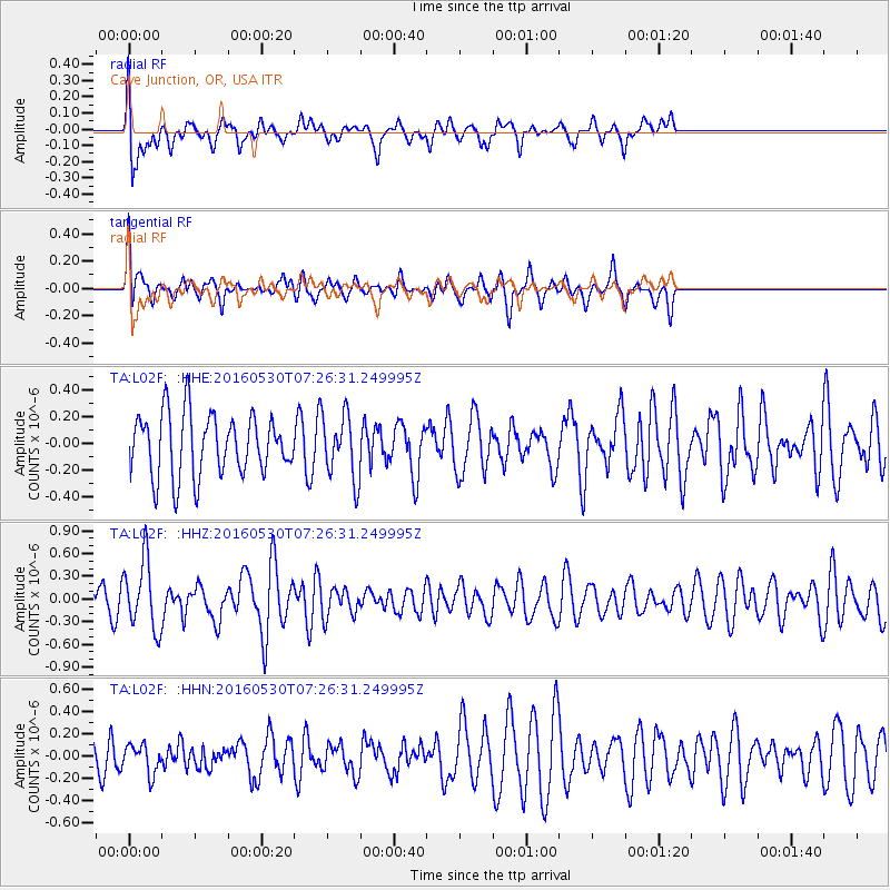
L02F Cave Junction, OR, USA - Earthquake Result Viewer
*The percent match for this event was below the threshold and hence no stack was calculated.
| Earthquake location: |
Kermadec Islands, New Zealand |
| Earthquake latitude/longitude: |
-30.4/-177.9 |
| Earthquake time(UTC): |
2016/05/30 (151) 07:14:16 GMT |
| Earthquake Depth: |
32 km |
| Earthquake Magnitude: |
5.7 MWB |
| Earthquake Catalog/Contributor: |
NEIC PDE/NEIC COMCAT |
|
| Network: |
TA USArray Transportable Network (new EarthScope stations) |
| Station: |
L02F Cave Junction, OR, USA |
| Lat/Lon: |
42.12 N/123.57 W |
| Elevation: |
440 m |
|
| Distance: |
87.8 deg |
| Az: |
37.239 deg |
| Baz: |
224.659 deg |
| Ray Param: |
$rayparam |
*The percent match for this event was below the threshold and hence was not used in the summary stack. |
|
| Radial Match: |
56.288185 % |
| Radial Bump: |
400 |
| Transverse Match: |
68.98722 % |
| Transverse Bump: |
400 |
| SOD ConfigId: |
7422571 |
| Insert Time: |
2019-04-22 16:44:15.017 +0000 |
| GWidth: |
2.5 |
| Max Bumps: |
400 |
| Tol: |
0.001 |
|
Signal To Noise
| Channel | StoN | STA | LTA |
| TA:L02F: :HHZ:20160530T07:26:31.249995Z | 1.7787054 | 4.5687466E-7 | 2.56858E-7 |
| TA:L02F: :HHN:20160530T07:26:31.249995Z | 0.92393535 | 1.2818052E-7 | 1.3873321E-7 |
| TA:L02F: :HHE:20160530T07:26:31.249995Z | 1.012741 | 2.3336817E-7 | 2.3043225E-7 |
| Arrivals |
| Ps | |
| PpPs | |
| PsPs/PpSs | |


