You are here: Home > Network List > TA - USArray Transportable Network (new EarthScope stations) Stations List
> Station L02F Cave Junction, OR, USA > Earthquake Result Viewer
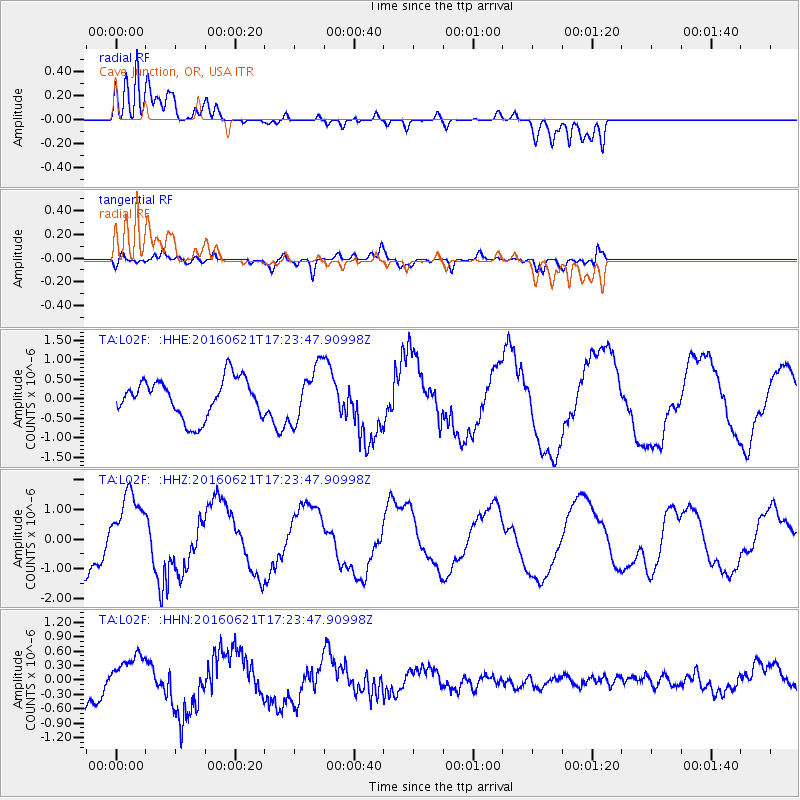
L02F Cave Junction, OR, USA - Earthquake Result Viewer
*The percent match for this event was below the threshold and hence no stack was calculated.
| Earthquake location: |
New Ireland Region, P.N.G. |
| Earthquake latitude/longitude: |
-3.5/151.9 |
| Earthquake time(UTC): |
2016/06/21 (173) 17:12:08 GMT |
| Earthquake Depth: |
365 km |
| Earthquake Magnitude: |
6.3 MWB |
| Earthquake Catalog/Contributor: |
NEIC PDE/NEIC COMCAT |
|
| Network: |
TA USArray Transportable Network (new EarthScope stations) |
| Station: |
L02F Cave Junction, OR, USA |
| Lat/Lon: |
42.12 N/123.57 W |
| Elevation: |
440 m |
|
| Distance: |
88.3 deg |
| Az: |
47.814 deg |
| Baz: |
263.816 deg |
| Ray Param: |
$rayparam |
*The percent match for this event was below the threshold and hence was not used in the summary stack. |
|
| Radial Match: |
91.367744 % |
| Radial Bump: |
400 |
| Transverse Match: |
80.09318 % |
| Transverse Bump: |
400 |
| SOD ConfigId: |
7422571 |
| Insert Time: |
2019-04-22 21:49:42.600 +0000 |
| GWidth: |
2.5 |
| Max Bumps: |
400 |
| Tol: |
0.001 |
|
Signal To Noise
| Channel | StoN | STA | LTA |
| TA:L02F: :HHZ:20160621T17:23:47.90998Z | 1.3546009 | 1.2007695E-6 | 8.864378E-7 |
| TA:L02F: :HHN:20160621T17:23:47.90998Z | 1.118431 | 4.0136703E-7 | 3.5886617E-7 |
| TA:L02F: :HHE:20160621T17:23:47.90998Z | 1.4543976 | 7.1249735E-7 | 4.8989176E-7 |
| Arrivals |
| Ps | |
| PpPs | |
| PsPs/PpSs | |


