You are here: Home > Network List > LD - Lamont-Doherty Cooperative Seismographic Network Stations List
> Station FMPA Franklin and Marshall College, PA > Earthquake Result Viewer
FMPA Franklin and Marshall College, PA - Earthquake Result Viewer
| Earthquake location: |
Near Coast Of Ecuador |
| Earthquake latitude/longitude: |
0.6/-79.6 |
| Earthquake time(UTC): |
2016/07/11 (193) 02:01:09 GMT |
| Earthquake Depth: |
14 km |
| Earthquake Magnitude: |
5.8 MWW, 5.7 MWB, 5.9 MWC |
| Earthquake Catalog/Contributor: |
NEIC PDE/NEIC COMCAT |
|
| Network: |
LD Lamont-Doherty Cooperative Seismographic Network |
| Station: |
FMPA Franklin and Marshall College, PA |
| Lat/Lon: |
40.05 N/76.32 W |
| Elevation: |
121 m |
|
| Distance: |
39.4 deg |
| Az: |
4.021 deg |
| Baz: |
185.241 deg |
| Ray Param: |
0.07499242 |
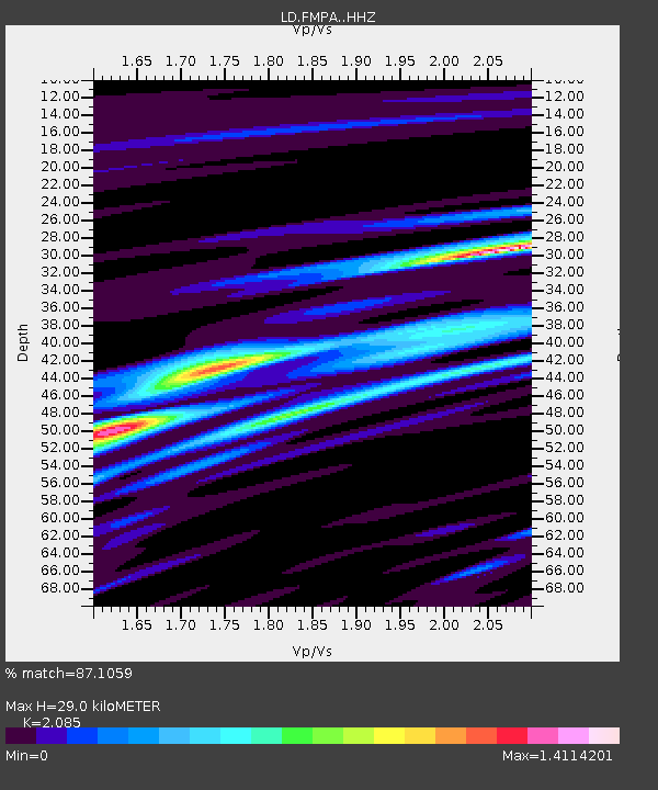
| Estimated Moho Depth: |
29.0 km |
| Estimated Crust Vp/Vs: |
2.09 |
| Assumed Crust Vp: |
6.121 km/s |
| Estimated Crust Vs: |
2.935 km/s |
| Estimated Crust Poisson's Ratio: |
0.35 |
|
| Radial Match: |
87.1059 % |
| Radial Bump: |
314 |
| Transverse Match: |
76.828445 % |
| Transverse Bump: |
400 |
| SOD ConfigId: |
11737051 |
| Insert Time: |
2019-04-25 01:23:01.577 +0000 |
| GWidth: |
2.5 |
| Max Bumps: |
400 |
| Tol: |
0.001 |
|

Signal To Noise
| Channel | StoN | STA | LTA |
| LD:FMPA: :HHZ:20160711T02:08:07.821989Z | 16.559711 | 1.9117181E-7 | 1.1544393E-8 |
| LD:FMPA: :HHN:20160711T02:08:07.821989Z | 6.8773365 | 1.7862087E-7 | 2.597239E-8 |
| LD:FMPA: :HHE:20160711T02:08:07.821989Z | 1.2540222 | 2.3825894E-8 | 1.8999579E-8 |
| Arrivals |
| Ps | 5.4 SECOND |
| PpPs | 14 SECOND |
| PsPs/PpSs | 19 SECOND |


