You are here: Home > Network List > GS - US Geological Survey Networks Stations List
> Station FBA1 ASL Experiment > Earthquake Result Viewer
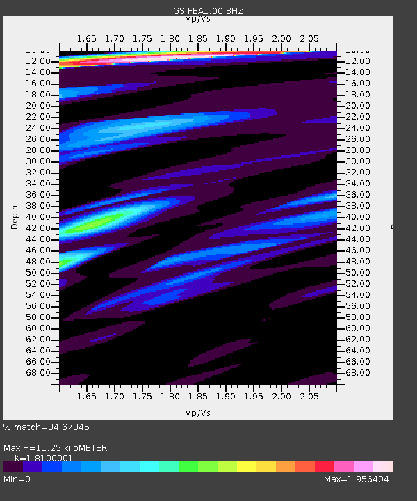
FBA1 ASL Experiment - Earthquake Result Viewer
| Earthquake location: |
Near Coast Of Ecuador |
| Earthquake latitude/longitude: |
0.6/-79.7 |
| Earthquake time(UTC): |
2016/07/11 (193) 02:11:04 GMT |
| Earthquake Depth: |
19 km |
| Earthquake Magnitude: |
6.3 MWW, 6.3 MWC, 6.3 MWB |
| Earthquake Catalog/Contributor: |
NEIC PDE/NEIC COMCAT |
|
| Network: |
GS US Geological Survey Networks |
| Station: |
FBA1 ASL Experiment |
| Lat/Lon: |
34.94 N/106.46 W |
| Elevation: |
1850 m |
|
| Distance: |
42.4 deg |
| Az: |
326.668 deg |
| Baz: |
138.022 deg |
| Ray Param: |
0.07318901 |
| Estimated Moho Depth: |
11.25 km |
| Estimated Crust Vp/Vs: |
1.81 |
| Assumed Crust Vp: |
6.502 km/s |
| Estimated Crust Vs: |
3.592 km/s |
| Estimated Crust Poisson's Ratio: |
0.28 |
|
| Radial Match: |
84.67845 % |
| Radial Bump: |
400 |
| Transverse Match: |
47.076466 % |
| Transverse Bump: |
400 |
| SOD ConfigId: |
11737051 |
| Insert Time: |
2019-04-25 01:36:36.656 +0000 |
| GWidth: |
2.5 |
| Max Bumps: |
400 |
| Tol: |
0.001 |
|

Signal To Noise
| Channel | StoN | STA | LTA |
| GS:FBA1:00:BHZ:20160711T02:18:26.64399Z | 1.9968284 | 4.220581E-7 | 2.1136422E-7 |
| GS:FBA1:00:BH1:20160711T02:18:26.64399Z | 1.3317864 | 3.7069404E-7 | 2.7834346E-7 |
| GS:FBA1:00:BH2:20160711T02:18:26.64399Z | 2.3048995 | 7.129509E-7 | 3.0931974E-7 |
| Arrivals |
| Ps | 1.5 SECOND |
| PpPs | 4.5 SECOND |
| PsPs/PpSs | 6.0 SECOND |


