
Station GS FBA1 - ASL Experiment
Network: GS - US Geological Survey Networks
Nearby stations (2 deg radius)
| Station | Name | (Lat, Lon) | Start / End | Elevation |
| FBA1 | ASL Experiment | (34.94, -106.46) | 2016-06-18 / 2016-07-24 | 1850 m |
| Crust2 Type: | X2,Rift, Rio Grande, Baikal, 0.5km sediments |
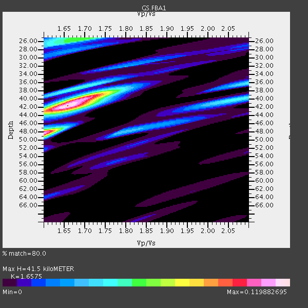
| Thickness Estimate: | 42 km |
| Thickness StdDev: | 0.1 km |
| Vp/Vs Estimate: | 1.66 |
| Vp/Vs StdDev: | 0.01 |
| Vs Estimate: | 3.922 km/s |
| Poisson's Ratio: | 0.21 |
| Peak Value: | 0.12 |
| Assumed Vp: | 6.502 km/s |
| Ps Weight: | 0.33333334 |
| PpPs Weight: | 0.33333334 |
| PsPs Weight: | 0.33333328 |
| Residual Complexity: | 0.621 |
| Nearby stations H: | 42 km +- 2.4 km |
| (2.0 deg) Vp/Vs: | 1.66 +- 0.04 |
1 with match > 90% ( 20.0 %) and 2 with match > 80% ( 40.0 %) out of 5.
Download stack as xyz text file.
Azimuth Distribution of Events:

Prior Results for this Station
| Study | Thickness | Vp/Vs | Vp | Vs | Poissons Ratio | Extra |
| EARS | 42 km | 1.66 | 6.502 km/s | 3.922 km/s | 0.21 | |
| Crust2.0 | 33 km | 1.77 | 6.502 km/s | 3.68 km/s | 0.26 | X2,Rift, Rio Grande, Baikal, 0.5km sediments |
| Global Maxima | 42 km | 1.66 | 6.502 km/s | 3.922 km/s | 0.21 | amp=0.119882695 |
| Local Maxima 1 | 48 km | 1.60 | 6.502 km/s | 4.063 km/s | 0.18 | amp=0.09314206 |
| Local Maxima 2 | 39 km | 1.71 | 6.502 km/s | 3.802 km/s | 0.24 | amp=0.07352051 |
| Local Maxima 3 | 25 km | 1.69 | 6.502 km/s | 3.847 km/s | 0.23 | amp=0.05863989 |
| Local Maxima 4 | 40 km | 2.08 | 6.502 km/s | 3.129 km/s | 0.35 | amp=0.041790053 |
| Predicted Arrivals for vertical incidence (zero ray parameter) | |
| Ps | 4.20 SECOND |
| PpPs | 16.96 SECOND |
| PsPs/PpSs | 21.16 SECOND |
Events Processed for this Station
Download zip of receiver functions as SAC
Plot maxima for each earthquake.
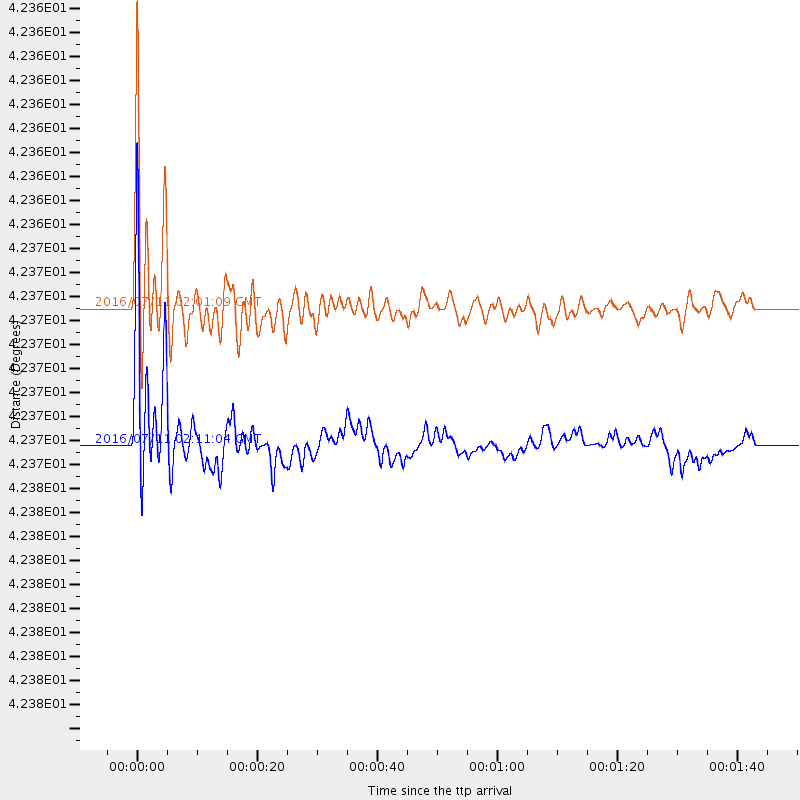
Events Used in the Stack
(2 events)| Radial Match | Distance | Baz | FERegion | Time | Lat/Lon | Depth | Magnitude |
| 91.21112 | 42.4 deg | 137.986 deg | Near Coast Of Ecuador | 2016/07/11 02:01:09 GMT | (0.6, -79.6) | 14 km | 5.8 MWW, 5.7 MWB, 5.9 MWC |
| 84.67845 | 42.4 deg | 138.022 deg | Near Coast Of Ecuador | 2016/07/11 02:11:04 GMT | (0.6, -79.7) | 19 km | 6.3 MWW, 6.3 MWC, 6.3 MWB |
Losers
(3 events)| Radial Match | Distance | Baz | FERegion | Time | Lat/Lon | Depth | Magnitude | Reason |
| 79.43423 | 69.7 deg | 141.856 deg | Chile-Argentina Border Region | 2016/06/18 17:29:44 GMT | (-24.2, -67.1) | 167 km | 5.5 MB | |
| 70.34808 | 42.6 deg | 140.212 deg | Near Coast Of Ecuador | 2016/07/08 04:28:43 GMT | (-0.4, -80.8) | 7.1 km | 5.5 mwb | |
| 63.850574 | 97.2 deg | 250.523 deg | Loyalty Islands | 2016/06/20 03:50:55 GMT | (-20.2, 168.8) | 15 km | 6.0 MWW, 5.8 MWB, 5.9 MWC, 6.0 MWC |

