You are here: Home > Network List > LD - Lamont-Doherty Cooperative Seismographic Network Stations List
> Station MIDE Milford, DE, USA > Earthquake Result Viewer
MIDE Milford, DE, USA - Earthquake Result Viewer
| Earthquake location: |
Near Coast Of Ecuador |
| Earthquake latitude/longitude: |
0.6/-79.7 |
| Earthquake time(UTC): |
2016/07/11 (193) 02:11:04 GMT |
| Earthquake Depth: |
19 km |
| Earthquake Magnitude: |
6.3 MWW, 6.3 MWC, 6.3 MWB |
| Earthquake Catalog/Contributor: |
NEIC PDE/NEIC COMCAT |
|
| Network: |
LD Lamont-Doherty Cooperative Seismographic Network |
| Station: |
MIDE Milford, DE, USA |
| Lat/Lon: |
38.88 N/75.33 W |
| Elevation: |
5.0 m |
|
| Distance: |
38.3 deg |
| Az: |
5.459 deg |
| Baz: |
187.001 deg |
| Ray Param: |
0.07559008 |
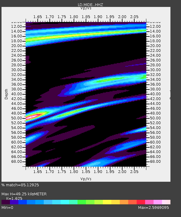
| Estimated Moho Depth: |
49.25 km |
| Estimated Crust Vp/Vs: |
1.62 |
| Assumed Crust Vp: |
6.287 km/s |
| Estimated Crust Vs: |
3.869 km/s |
| Estimated Crust Poisson's Ratio: |
0.20 |
|
| Radial Match: |
85.12925 % |
| Radial Bump: |
358 |
| Transverse Match: |
56.107357 % |
| Transverse Bump: |
400 |
| SOD ConfigId: |
11737051 |
| Insert Time: |
2019-04-25 01:37:12.842 +0000 |
| GWidth: |
2.5 |
| Max Bumps: |
400 |
| Tol: |
0.001 |
|
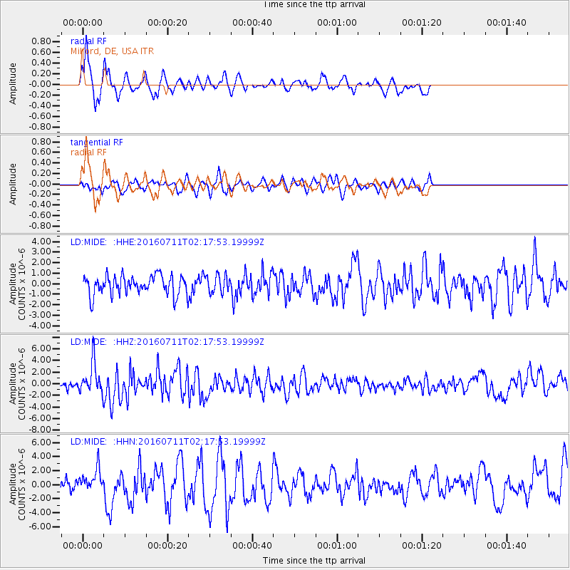
Signal To Noise
| Channel | StoN | STA | LTA |
| LD:MIDE: :HHZ:20160711T02:17:53.19999Z | 4.3116646 | 2.6827258E-6 | 6.222019E-7 |
| LD:MIDE: :HHN:20160711T02:17:53.19999Z | 1.8846619 | 1.685022E-6 | 8.940712E-7 |
| LD:MIDE: :HHE:20160711T02:17:53.19999Z | 0.87994915 | 8.0970204E-7 | 9.201691E-7 |
| Arrivals |
| Ps | 5.3 SECOND |
| PpPs | 19 SECOND |
| PsPs/PpSs | 24 SECOND |


