You are here: Home > Network List > TA - USArray Transportable Network (new EarthScope stations) Stations List
> Station L02F Cave Junction, OR, USA > Earthquake Result Viewer
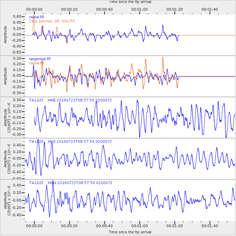
L02F Cave Junction, OR, USA - Earthquake Result Viewer
*The percent match for this event was below the threshold and hence no stack was calculated.
| Earthquake location: |
Off Coast Of Guerrero, Mexico |
| Earthquake latitude/longitude: |
14.9/-103.5 |
| Earthquake time(UTC): |
2016/07/23 (205) 08:52:02 GMT |
| Earthquake Depth: |
45 km |
| Earthquake Magnitude: |
5.5 MB |
| Earthquake Catalog/Contributor: |
NEIC PDE/NEIC COMCAT |
|
| Network: |
TA USArray Transportable Network (new EarthScope stations) |
| Station: |
L02F Cave Junction, OR, USA |
| Lat/Lon: |
42.12 N/123.57 W |
| Elevation: |
440 m |
|
| Distance: |
32.2 deg |
| Az: |
331.424 deg |
| Baz: |
141.558 deg |
| Ray Param: |
$rayparam |
*The percent match for this event was below the threshold and hence was not used in the summary stack. |
|
| Radial Match: |
63.00311 % |
| Radial Bump: |
393 |
| Transverse Match: |
42.045765 % |
| Transverse Bump: |
400 |
| SOD ConfigId: |
11737051 |
| Insert Time: |
2019-04-25 03:32:02.388 +0000 |
| GWidth: |
2.5 |
| Max Bumps: |
400 |
| Tol: |
0.001 |
|
Signal To Noise
| Channel | StoN | STA | LTA |
| TA:L02F: :HHZ:20160723T08:57:56.020007Z | 2.5424716 | 3.3725814E-7 | 1.3264972E-7 |
| TA:L02F: :HHN:20160723T08:57:56.020007Z | 0.9213352 | 1.3925471E-7 | 1.5114446E-7 |
| TA:L02F: :HHE:20160723T08:57:56.020007Z | 1.2294109 | 1.2294353E-7 | 1.0000199E-7 |
| Arrivals |
| Ps | |
| PpPs | |
| PsPs/PpSs | |


