You are here: Home > Network List > 8G - 2016 Pedernales Earthquake Aftershock Deployment Ecuador Stations List
> Station EC12 EC12 > Earthquake Result Viewer
EC12 EC12 - Earthquake Result Viewer
| Earthquake location: |
South Georgia Island Region |
| Earthquake latitude/longitude: |
-55.3/-31.9 |
| Earthquake time(UTC): |
2016/08/19 (232) 07:32:22 GMT |
| Earthquake Depth: |
10 km |
| Earthquake Magnitude: |
7.4 MO |
| Earthquake Catalog/Contributor: |
NEIC PDE/NEIC COMCAT |
|
| Network: |
8G 2016 Pedernales Earthquake Aftershock Deployment Ecuador |
| Station: |
EC12 EC12 |
| Lat/Lon: |
0.41 N/79.98 W |
| Elevation: |
54 m |
|
| Distance: |
67.9 deg |
| Az: |
306.625 deg |
| Baz: |
152.709 deg |
| Ray Param: |
0.056650788 |
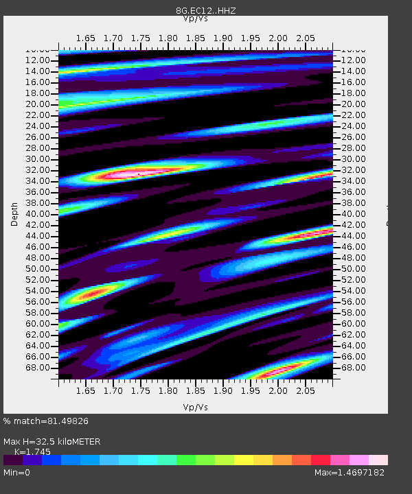
| Estimated Moho Depth: |
32.5 km |
| Estimated Crust Vp/Vs: |
1.75 |
| Assumed Crust Vp: |
6.472 km/s |
| Estimated Crust Vs: |
3.709 km/s |
| Estimated Crust Poisson's Ratio: |
0.26 |
|
| Radial Match: |
81.49826 % |
| Radial Bump: |
400 |
| Transverse Match: |
73.146126 % |
| Transverse Bump: |
400 |
| SOD ConfigId: |
11737051 |
| Insert Time: |
2019-04-25 07:10:29.423 +0000 |
| GWidth: |
2.5 |
| Max Bumps: |
400 |
| Tol: |
0.001 |
|

Signal To Noise
| Channel | StoN | STA | LTA |
| 8G:EC12: :HHZ:20160819T07:42:50.145007Z | 29.391073 | 2.0663343E-5 | 7.030483E-7 |
| 8G:EC12: :HHN:20160819T07:42:50.145007Z | 9.264124 | 5.9303247E-6 | 6.4013875E-7 |
| 8G:EC12: :HHE:20160819T07:42:50.145007Z | 2.6958106 | 3.425215E-6 | 1.2705697E-6 |
| Arrivals |
| Ps | 3.9 SECOND |
| PpPs | 13 SECOND |
| PsPs/PpSs | 17 SECOND |


