
Station 8G EC12 - EC12
Network: 8G - 2016 Pedernales Earthquake Aftershock Deployment Ecuador
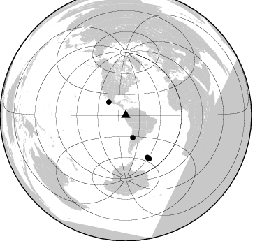
Nearby stations (2 deg radius)
| Station | Name | (Lat, Lon) | Start / End | Elevation |
| EC12 | EC12 | (0.41, -79.98) | 2016-05-01 / 2017-05-10 | 54 m |
| Crust2 Type: | T6,Margin /shield transition, 1 km seds. |
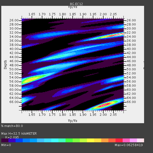
| Thickness Estimate: | 32 km |
| Thickness StdDev: | 13 km |
| Vp/Vs Estimate: | 2.10 |
| Vp/Vs StdDev: | 0.20 |
| Vs Estimate: | 3.089 km/s |
| Poisson's Ratio: | 0.35 |
| Peak Value: | 0.06 |
| Assumed Vp: | 6.472 km/s |
| Ps Weight: | 0.33333334 |
| PpPs Weight: | 0.33333334 |
| PsPs Weight: | 0.33333328 |
| Residual Complexity: | 0.819 |
| Nearby stations H: | +- |
| (2.0 deg) Vp/Vs: | +- |
0 with match > 90% ( 0.0 %) and 4 with match > 80% ( 40.0 %) out of 10.
Download stack as xyz text file.
Azimuth Distribution of Events:
Prior Results for this Station
| Study | Thickness | Vp/Vs | Vp | Vs | Poissons Ratio | Extra |
| EARS | 32 km | 2.10 | 6.472 km/s | 3.089 km/s | 0.35 | |
| Crust2.0 | 32 km | 1.79 | 6.472 km/s | 3.622 km/s | 0.27 | T6,Margin /shield transition, 1 km seds. |
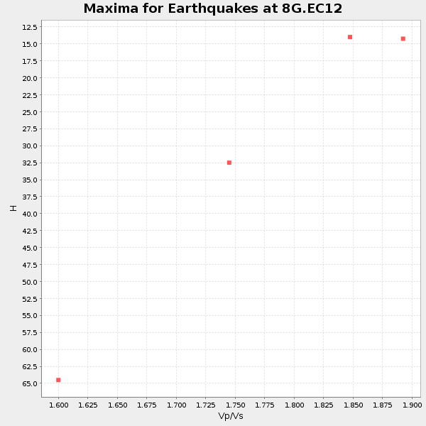
| Global Maxima | 32 km | 2.10 | 6.472 km/s | 3.089 km/s | 0.35 | amp=0.06258419 |
| Local Maxima 1 | 67 km | 2.00 | 6.472 km/s | 3.232 km/s | 0.33 | amp=0.055655852 |
| Local Maxima 2 | 54 km | 1.66 | 6.472 km/s | 3.905 km/s | 0.21 | amp=0.033003557 |
| Local Maxima 3 | 66 km | 1.60 | 6.472 km/s | 4.045 km/s | 0.18 | amp=0.029974373 |
| Local Maxima 4 | 44 km | 1.76 | 6.472 km/s | 3.677 km/s | 0.26 | amp=0.025215732 |
| Predicted Arrivals for vertical incidence (zero ray parameter) | |
| Ps | 5.50 SECOND |
| PpPs | 15.54 SECOND |
| PsPs/PpSs | 21.04 SECOND |
Events Processed for this Station
Download zip of receiver functions as SAC
Plot maxima for each earthquake.
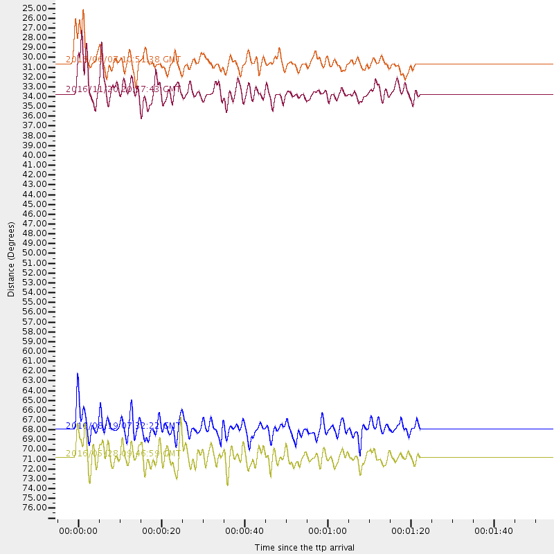
Events Used in the Stack
(4 events)| Radial Match | Distance | Baz | FERegion | Time | Lat/Lon | Depth | Magnitude |
| 87.2196 | 33.6 deg | 162.555 deg | San Juan Province, Argentina | 2016/11/20 20:57:43 GMT | (-31.6, -68.8) | 116 km | 6.4 MWP, 6.5 MWB |
| 82.5735 | 70.7 deg | 151.752 deg | South Sandwich Islands Region | 2016/05/28 09:46:59 GMT | (-56.2, -26.9) | 73 km | 7.2 MWW, 7.3 MI |
| 82.18788 | 30.5 deg | 307.284 deg | Off Coast Of Jalisco, Mexico | 2016/06/07 10:51:38 GMT | (18.4, -105.2) | 10 km | 6.2 MWP |
| 81.49826 | 67.9 deg | 152.709 deg | South Georgia Island Region | 2016/08/19 07:32:22 GMT | (-55.3, -31.9) | 10 km | 7.4 MO |
Losers
(6 events)| Radial Match | Distance | Baz | FERegion | Time | Lat/Lon | Depth | Magnitude | Reason |
| 75.34529 | 68.0 deg | 152.587 deg | South Georgia Island Region | 2016/08/21 03:45:23 GMT | (-55.3, -31.8) | 10 km | 6.4 MWP | |
| 66.540565 | 70.5 deg | 152.007 deg | South Sandwich Islands Region | 2016/07/31 11:33:20 GMT | (-56.3, -27.5) | 98 km | 5.9 MWW, 5.9 MWC, 5.9 MWB | |
| 64.89007 | 31.4 deg | 166.678 deg | Off Coast Of Central Chile | 2016/07/19 05:18:40 GMT | (-30.2, -72.0) | 14 km | 5.5 MB | |
| 63.788643 | 36.3 deg | 167.511 deg | Chile-Argentina Border Region | 2016/11/04 16:20:43 GMT | (-35.1, -71.0) | 91 km | 6.4 MWP, 6.4 MWW | |
| 58.35044 | 31.4 deg | 165.708 deg | Near Coast Of Central Chile | 2016/06/06 13:16:02 GMT | (-30.1, -71.5) | 30 km | 5.5 MWW, 5.4 MWB | |
| 43.70701 | 94.9 deg | 251.987 deg | Tonga Islands | 2016/09/24 21:07:13 GMT | (-18.1, -175.0) | 179 km | 6.3 MO |

