You are here: Home > Network List > TA - USArray Transportable Network (new EarthScope stations) Stations List
> Station L02F Cave Junction, OR, USA > Earthquake Result Viewer
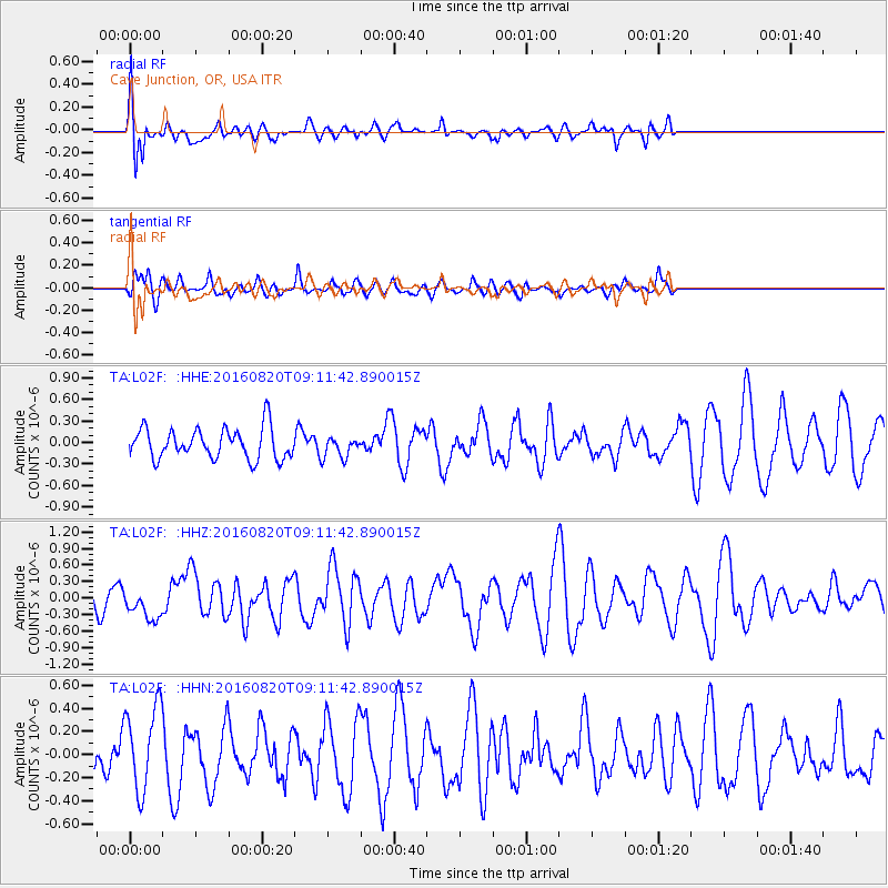
L02F Cave Junction, OR, USA - Earthquake Result Viewer
*The percent match for this event was below the threshold and hence no stack was calculated.
| Earthquake location: |
Off East Coast Of Honshu, Japan |
| Earthquake latitude/longitude: |
40.4/143.7 |
| Earthquake time(UTC): |
2016/08/20 (233) 09:01:26 GMT |
| Earthquake Depth: |
10 km |
| Earthquake Magnitude: |
6.0 MO |
| Earthquake Catalog/Contributor: |
NEIC PDE/NEIC ALERT |
|
| Network: |
TA USArray Transportable Network (new EarthScope stations) |
| Station: |
L02F Cave Junction, OR, USA |
| Lat/Lon: |
42.12 N/123.57 W |
| Elevation: |
440 m |
|
| Distance: |
66.2 deg |
| Az: |
54.317 deg |
| Baz: |
303.456 deg |
| Ray Param: |
$rayparam |
*The percent match for this event was below the threshold and hence was not used in the summary stack. |
|
| Radial Match: |
57.309208 % |
| Radial Bump: |
400 |
| Transverse Match: |
55.794876 % |
| Transverse Bump: |
400 |
| SOD ConfigId: |
11737051 |
| Insert Time: |
2019-04-25 07:37:53.935 +0000 |
| GWidth: |
2.5 |
| Max Bumps: |
400 |
| Tol: |
0.001 |
|
Signal To Noise
| Channel | StoN | STA | LTA |
| TA:L02F: :HHZ:20160820T09:11:42.890015Z | 1.1032692 | 2.7897147E-7 | 2.5285894E-7 |
| TA:L02F: :HHN:20160820T09:11:42.890015Z | 2.7800891 | 3.659537E-7 | 1.316338E-7 |
| TA:L02F: :HHE:20160820T09:11:42.890015Z | 0.7191676 | 1.544934E-7 | 2.1482255E-7 |
| Arrivals |
| Ps | |
| PpPs | |
| PsPs/PpSs | |


