You are here: Home > Network List > TA - USArray Transportable Network (new EarthScope stations) Stations List
> Station L02F Cave Junction, OR, USA > Earthquake Result Viewer
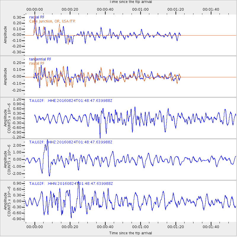
L02F Cave Junction, OR, USA - Earthquake Result Viewer
*The percent match for this event was below the threshold and hence no stack was calculated.
| Earthquake location: |
Central Italy |
| Earthquake latitude/longitude: |
42.7/13.2 |
| Earthquake time(UTC): |
2016/08/24 (237) 01:36:33 GMT |
| Earthquake Depth: |
10 km |
| Earthquake Magnitude: |
6.2 MWP |
| Earthquake Catalog/Contributor: |
NEIC PDE/NEIC COMCAT |
|
| Network: |
TA USArray Transportable Network (new EarthScope stations) |
| Station: |
L02F Cave Junction, OR, USA |
| Lat/Lon: |
42.12 N/123.57 W |
| Elevation: |
440 m |
|
| Distance: |
87.0 deg |
| Az: |
329.301 deg |
| Baz: |
30.381 deg |
| Ray Param: |
$rayparam |
*The percent match for this event was below the threshold and hence was not used in the summary stack. |
|
| Radial Match: |
75.46346 % |
| Radial Bump: |
396 |
| Transverse Match: |
72.41465 % |
| Transverse Bump: |
400 |
| SOD ConfigId: |
11737051 |
| Insert Time: |
2019-04-25 08:31:50.777 +0000 |
| GWidth: |
2.5 |
| Max Bumps: |
400 |
| Tol: |
0.001 |
|
Signal To Noise
| Channel | StoN | STA | LTA |
| TA:L02F: :HHZ:20160824T01:48:47.639988Z | 5.2447143 | 7.4226756E-7 | 1.4152678E-7 |
| TA:L02F: :HHN:20160824T01:48:47.639988Z | 1.4211257 | 2.3145722E-7 | 1.6286894E-7 |
| TA:L02F: :HHE:20160824T01:48:47.639988Z | 1.4513875 | 2.3574724E-7 | 1.6242886E-7 |
| Arrivals |
| Ps | |
| PpPs | |
| PsPs/PpSs | |


