You are here: Home > Network List > US - United States National Seismic Network Stations List
> Station TUC Tucson, Arizona, USA > Earthquake Result Viewer
TUC Tucson, Arizona, USA - Earthquake Result Viewer
| Earthquake location: |
Tonga Islands |
| Earthquake latitude/longitude: |
-16.8/-174.2 |
| Earthquake time(UTC): |
2004/01/25 (025) 11:43:11 GMT |
| Earthquake Depth: |
130 km |
| Earthquake Magnitude: |
6.4 MB, 6.7 MW, 6.7 MW |
| Earthquake Catalog/Contributor: |
WHDF/NEIC |
|
| Network: |
US United States National Seismic Network |
| Station: |
TUC Tucson, Arizona, USA |
| Lat/Lon: |
32.31 N/110.78 W |
| Elevation: |
906 m |
|
| Distance: |
77.9 deg |
| Az: |
50.759 deg |
| Baz: |
241.156 deg |
| Ray Param: |
0.04970832 |
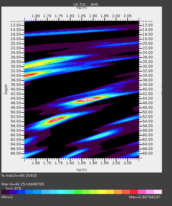
| Estimated Moho Depth: |
44.25 km |
| Estimated Crust Vp/Vs: |
1.88 |
| Assumed Crust Vp: |
6.276 km/s |
| Estimated Crust Vs: |
3.347 km/s |
| Estimated Crust Poisson's Ratio: |
0.30 |
|
| Radial Match: |
98.05405 % |
| Radial Bump: |
216 |
| Transverse Match: |
93.941444 % |
| Transverse Bump: |
400 |
| SOD ConfigId: |
110177 |
| Insert Time: |
2010-03-05 06:36:20.140 +0000 |
| GWidth: |
2.5 |
| Max Bumps: |
400 |
| Tol: |
0.001 |
|

Signal To Noise
| Channel | StoN | STA | LTA |
| US:TUC: :BHN:20040125T11:54:24.273015Z | 4.6794057 | 4.1874392E-7 | 8.9486555E-8 |
| US:TUC: :BHE:20040125T11:54:24.273015Z | 13.275005 | 8.811578E-7 | 6.637721E-8 |
| US:TUC: :BHZ:20040125T11:54:24.273015Z | 15.926872 | 2.1010642E-6 | 1.3191944E-7 |
| Arrivals |
| Ps | 6.3 SECOND |
| PpPs | 20 SECOND |
| PsPs/PpSs | 26 SECOND |


