
Station US TUC - Tucson, Arizona, USA
Network: US - United States National Seismic Network
Nearby stations (2 deg radius)
| Station | Name | (Lat, Lon) | Start / End | Elevation |
| TUC | Tucson, Arizona, USA | (32.31, -110.78) | 1999-03-03 / 2499-01-01 | 906 m |
| Crust2 Type: | M5,extended crust, 0.5 km seds. |
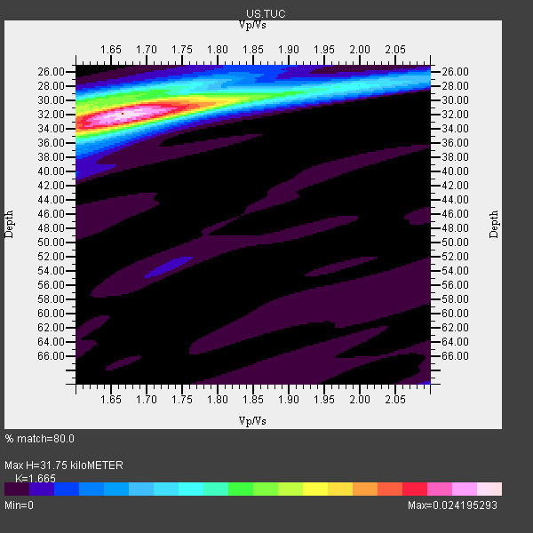
| Thickness Estimate: | 32 km |
| Thickness StdDev: | 0.5 km |
| Vp/Vs Estimate: | 1.66 |
| Vp/Vs StdDev: | 0.02 |
| Vs Estimate: | 3.769 km/s |
| Poisson's Ratio: | 0.22 |
| Peak Value: | 0.02 |
| Assumed Vp: | 6.276 km/s |
| Ps Weight: | 0.33333334 |
| PpPs Weight: | 0.33333334 |
| PsPs Weight: | 0.33333328 |
| Residual Complexity: | 0.477 |
| Nearby stations H: | 32 km +- 0.0 km |
| (2.0 deg) Vp/Vs: | 1.68 +- 0.03 |
25 with match > 90% ( 62.5 %) and 40 with match > 80% ( 100.0 %) out of 40.
Download stack as xyz text file.
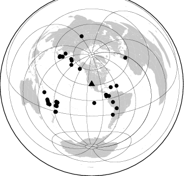
Azimuth Distribution of Events:
Prior Results for this Station
| Study | Thickness | Vp/Vs | Vp | Vs | Poissons Ratio | Extra |
| EARS | 32 km | 1.66 | 6.276 km/s | 3.769 km/s | 0.22 | |
| Crust2.0 | 31 km | 1.78 | 6.276 km/s | 3.529 km/s | 0.27 | M5,extended crust, 0.5 km seds. |
| Zandt Ammon | 30 km | 1.69 | 6.0 km/s | 3.55 km/s | 0.23 | |
| Zandt Ammon | 32 km | 1.68 | 6.25 km/s | 3.72 km/s | 0.23 | |
| Zandt Ammon | 33 km | 1.68 | 6.5 km/s | 3.869 km/s | 0.23 | |
| Zandt Ammon | 34 km | 1.67 | 6.75 km/s | 4.042 km/s | 0.22 | |
| Global Maxima | 32 km | 1.66 | 6.276 km/s | 3.769 km/s | 0.22 | amp=0.024195293 |
| Local Maxima 1 | 33 km | 1.66 | 6.276 km/s | 3.769 km/s | 0.22 | amp=0.01307021 |
| Local Maxima 2 | 31 km | 1.60 | 6.276 km/s | 3.922 km/s | 0.18 | amp=0.010633304 |
| Local Maxima 3 | 30 km | 1.72 | 6.276 km/s | 3.649 km/s | 0.24 | amp=0.005482842 |
| Local Maxima 4 | 30 km | 1.60 | 6.276 km/s | 3.922 km/s | 0.18 | amp=0.004366997 |
| Predicted Arrivals for vertical incidence (zero ray parameter) | |
| Ps | 3.36 SECOND |
| PpPs | 13.48 SECOND |
| PsPs/PpSs | 16.85 SECOND |
Events Processed for this Station
Download zip of receiver functions as SAC
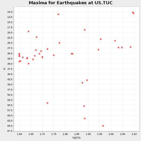
Plot maxima for each earthquake.
Events Used in the Stack
(40 events)| Radial Match | Distance | Baz | FERegion | Time | Lat/Lon | Depth | Magnitude |
| 98.36305 | 79.3 deg | 312.79 deg | Hokkaido, Japan Region | 2003/09/25 19:50:06 GMT | (41.8, 143.9) | 27 km | 6.9 MB, 8.1 MS, 8.3 MW, 8.1 MW |
| 98.165 | 82.4 deg | 311.353 deg | Near East Coast Of Honshu, Japan | 2003/05/26 09:24:33 GMT | (38.8, 141.6) | 68 km | 6.7 MB, 7.0 MW, 7.0 MW |
| 98.05405 | 77.9 deg | 241.156 deg | Tonga Islands | 2004/01/25 11:43:11 GMT | (-16.8, -174.2) | 130 km | 6.4 MB, 6.7 MW, 6.7 MW |
| 97.75903 | 89.4 deg | 232.836 deg | Kermadec Islands, New Zealand | 2003/05/04 13:15:18 GMT | (-30.5, -178.2) | 62 km | 6.0 MB, 6.5 MS, 6.7 MW, 6.7 MW |
| 97.445816 | 94.2 deg | 260.338 deg | Solomon Islands | 2003/01/20 08:43:06 GMT | (-10.5, 160.8) | 33 km | 6.7 MB, 7.8 MS, 7.3 MW, 7.2 MW |
| 97.37386 | 82.3 deg | 239.268 deg | Fiji Islands Region | 2003/07/27 02:04:11 GMT | (-21.1, -176.6) | 213 km | 5.9 MB, 6.6 MW, 6.6 MW |
| 97.320755 | 72.7 deg | 145.253 deg | Near Coast Of Central Chile | 2003/06/20 13:30:41 GMT | (-30.6, -71.6) | 33 km | 6.4 MB, 6.8 MS, 6.8 MW, 6.7 MW |
| 96.62258 | 93.1 deg | 246.011 deg | Southeast Of Loyalty Islands | 2003/12/27 16:00:59 GMT | (-22.0, 169.8) | 10 km | 6.1 MB, 7.1 MS, 7.3 MW, 7.2 MW |
| 96.40961 | 76.2 deg | 241.812 deg | Tonga Islands | 2003/09/02 18:28:00 GMT | (-15.2, -173.2) | 10 km | 6.0 MB, 6.6 MS, 6.4 MW, 6.3 MW |
| 95.67164 | 63.6 deg | 320.574 deg | Kamchatka Peninsula, Russia | 2003/06/16 22:08:02 GMT | (55.5, 160.0) | 175 km | 6.3 MB, 6.9 MW, 6.9 MW |
| 95.4217 | 88.7 deg | 232.458 deg | Kermadec Islands, New Zealand | 2003/09/30 14:08:37 GMT | (-30.4, -177.4) | 10 km | 5.8 MB, 6.5 MS, 6.4 MW, 6.4 MW |
| 94.97657 | 79.0 deg | 319.188 deg | Primor'ye, Russia | 2003/07/27 06:25:31 GMT | (47.2, 139.2) | 470 km | 6.3 MB, 6.8 MW, 6.8 MW |
| 94.89098 | 54.4 deg | 129.817 deg | Western Brazil | 2003/06/20 06:19:38 GMT | (-7.6, -71.7) | 558 km | 6.4 MB, 7.1 MW, 7.0 MW |
| 94.83015 | 82.3 deg | 310.018 deg | Off East Coast Of Honshu, Japan | 2003/10/31 01:06:28 GMT | (37.8, 142.6) | 10 km | 6.1 MB, 6.8 MS, 7.0 MW, 7.0 MW |
| 94.431244 | 54.9 deg | 313.178 deg | Rat Islands, Aleutian Islands | 2003/06/23 12:12:34 GMT | (51.4, 176.8) | 20 km | 6.3 MB, 7.0 MS, 6.9 MW, 6.8 MW |
| 93.81798 | 76.5 deg | 242.21 deg | Tonga Islands | 2003/05/03 05:03:03 GMT | (-15.1, -173.7) | 33 km | 6.3 MB, 6.1 MS, 6.2 MW, 6.1 MW |
| 93.72576 | 84.0 deg | 52.085 deg | Strait Of Gibraltar | 2004/02/24 02:27:46 GMT | (35.1, -4.0) | 0.0 km | 6.2 MB, 6.4 MS, 6.4 MW, 6.4 MW |
| 93.51876 | 35.2 deg | 126.378 deg | Panama-Costa Rica Border Region | 2003/12/25 07:11:11 GMT | (8.4, -82.8) | 33 km | 6.0 MB, 6.4 MS, 6.5 MW, 6.5 MW |
| 93.17904 | 48.7 deg | 93.534 deg | North Atlantic Ocean | 2003/05/14 06:03:35 GMT | (18.3, -58.6) | 42 km | 6.5 MB, 6.5 MS, 6.6 MW, 6.6 MW |
| 93.10682 | 96.4 deg | 348.058 deg | Southwestern Siberia, Russia | 2003/09/27 11:33:25 GMT | (50.0, 87.8) | 16 km | 6.5 MB, 7.5 MS, 7.3 MW, 7.3 MW |
| 92.082085 | 60.5 deg | 319.539 deg | Komandorskiye Ostrova Region | 2003/12/05 21:26:09 GMT | (55.5, 165.8) | 10 km | 6.1 MB, 6.5 MS, 6.7 MW, 6.7 MW |
| 90.84334 | 37.9 deg | 99.203 deg | Dominican Republic Region | 2003/09/22 04:45:36 GMT | (19.8, -70.7) | 10 km | 6.2 MB, 6.6 MS, 6.5 MW, 6.4 MW |
| 90.588104 | 83.0 deg | 311.261 deg | Eastern Honshu, Japan | 2003/07/25 22:13:29 GMT | (38.4, 141.0) | 6.0 km | 6.0 MB, 5.8 MS, 6.1 MW, 5.9 MW |
| 90.58513 | 37.3 deg | 129.266 deg | South Of Panama | 2003/05/23 11:05:11 GMT | (5.7, -82.7) | 10 km | 5.1 MB, 5.4 MS, 5.9 MW, 5.9 MW |
| 90.03699 | 92.3 deg | 248.751 deg | Vanuatu Islands | 2003/11/06 10:38:04 GMT | (-19.3, 168.9) | 114 km | 6.0 MB, 6.6 MW, 6.6 MW |
| 89.4766 | 78.4 deg | 313.222 deg | Hokkaido, Japan Region | 2003/10/08 09:06:55 GMT | (42.6, 144.6) | 32 km | 6.0 MB, 6.6 MS, 6.7 MW, 6.6 MW |
| 89.36227 | 36.5 deg | 127.4 deg | South Of Panama | 2003/04/11 06:12:54 GMT | (7.0, -82.4) | 10 km | 5.6 MB, 5.6 MS, 6.2 MW, 6.1 MW |
| 88.79295 | 89.4 deg | 232.824 deg | Kermadec Islands, New Zealand | 2003/05/04 20:08:46 GMT | (-30.6, -178.3) | 46 km | 6.0 MB, 6.1 MS, 6.4 MW, 6.4 MW |
| 88.627075 | 93.5 deg | 245.956 deg | Southeast Of Loyalty Islands | 2003/12/25 20:42:33 GMT | (-22.3, 169.5) | 10 km | 6.3 MB, 6.3 MS, 6.5 MW, 6.4 MW |
| 88.62658 | 41.1 deg | 124.385 deg | Near West Coast Of Colombia | 2003/11/05 00:58:51 GMT | (5.0, -77.8) | 33 km | 5.7 MB, 5.4 MS, 6.0 MW, 5.9 MW |
| 87.6209 | 76.4 deg | 241.916 deg | Tonga Islands | 2003/03/28 17:31:47 GMT | (-15.3, -173.5) | 41 km | 5.8 MB, 6.0 MS, 6.2 MW, 6.1 MW |
| 87.389725 | 77.7 deg | 243.698 deg | Samoa Islands Region | 2004/02/23 16:04:49 GMT | (-14.7, -175.6) | 31 km | 5.7 MB, 6.3 MS, 6.3 MW, 6.2 MW |
| 86.80216 | 37.0 deg | 172.135 deg | Central East Pacific Rise | 2003/09/06 02:08:13 GMT | (-4.6, -106.0) | 10 km | 5.4 MB, 5.8 MS, 6.1 MW, 6.0 MW |
| 84.872665 | 91.6 deg | 244.413 deg | Southeast Of Loyalty Islands | 2003/09/07 13:19:20 GMT | (-22.5, 172.1) | 33 km | 5.7 MB, 6.4 MS, 6.3 MW, 6.3 MW |
| 84.80937 | 92.1 deg | 250.993 deg | Vanuatu Islands | 2003/05/13 21:21:14 GMT | (-17.3, 167.7) | 33 km | 6.0 MB, 6.4 MS, 6.3 MW, 6.3 MW |
| 84.79519 | 68.0 deg | 133.607 deg | Southern Bolivia | 2003/07/27 11:41:27 GMT | (-20.1, -65.2) | 345 km | 5.9 MB, 6.0 MW, 6.0 MW |
| 84.26774 | 80.9 deg | 237.882 deg | Tonga Islands | 2003/07/03 06:21:50 GMT | (-21.3, -174.5) | 10 km | 5.5 MB, 5.7 MS, 6.0 MW |
| 82.93579 | 35.2 deg | 126.513 deg | Panama-Costa Rica Border Region | 2004/02/04 11:59:47 GMT | (8.4, -82.9) | 29 km | 5.6 MB, 5.9 MS, 6.1 MW, 6.1 MW |
| 82.04427 | 92.9 deg | 246.26 deg | Southeast Of Loyalty Islands | 2003/12/27 22:38:01 GMT | (-21.7, 169.8) | 10 km | 5.8 MB, 6.7 MS, 6.7 MW, 6.7 MW |
| 81.33101 | 37.8 deg | 321.84 deg | Kodiak Island Region, Alaska | 2003/08/03 04:10:50 GMT | (56.1, -153.3) | 17 km | 5.2 MB, 5.3 MS, 5.7 MW, 5.7 MW |
Losers
(0 events)| Radial Match | Distance | Baz | FERegion | Time | Lat/Lon | Depth | Magnitude | Reason |
