You are here: Home > Network List > US - United States National Seismic Network Stations List
> Station TUC Tucson, Arizona, USA > Earthquake Result Viewer
TUC Tucson, Arizona, USA - Earthquake Result Viewer
| Earthquake location: |
Near West Coast Of Colombia |
| Earthquake latitude/longitude: |
5.0/-77.8 |
| Earthquake time(UTC): |
2003/11/05 (309) 00:58:51 GMT |
| Earthquake Depth: |
33 km |
| Earthquake Magnitude: |
5.7 MB, 5.4 MS, 6.0 MW, 5.9 MW |
| Earthquake Catalog/Contributor: |
WHDF/NEIC |
|
| Network: |
US United States National Seismic Network |
| Station: |
TUC Tucson, Arizona, USA |
| Lat/Lon: |
32.31 N/110.78 W |
| Elevation: |
906 m |
|
| Distance: |
41.1 deg |
| Az: |
315.459 deg |
| Baz: |
124.385 deg |
| Ray Param: |
0.07391865 |
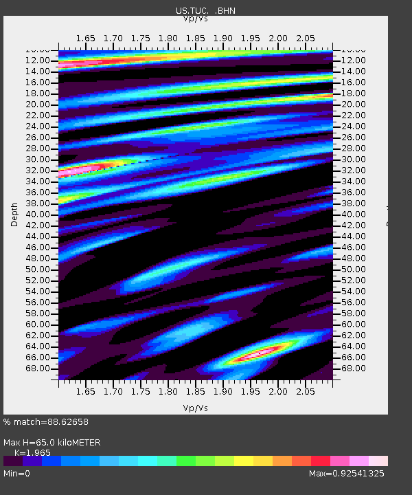
| Estimated Moho Depth: |
65.0 km |
| Estimated Crust Vp/Vs: |
1.97 |
| Assumed Crust Vp: |
6.276 km/s |
| Estimated Crust Vs: |
3.194 km/s |
| Estimated Crust Poisson's Ratio: |
0.33 |
|
| Radial Match: |
88.62658 % |
| Radial Bump: |
303 |
| Transverse Match: |
67.50832 % |
| Transverse Bump: |
400 |
| SOD ConfigId: |
110165 |
| Insert Time: |
2010-03-05 06:36:27.688 +0000 |
| GWidth: |
2.5 |
| Max Bumps: |
400 |
| Tol: |
0.001 |
|
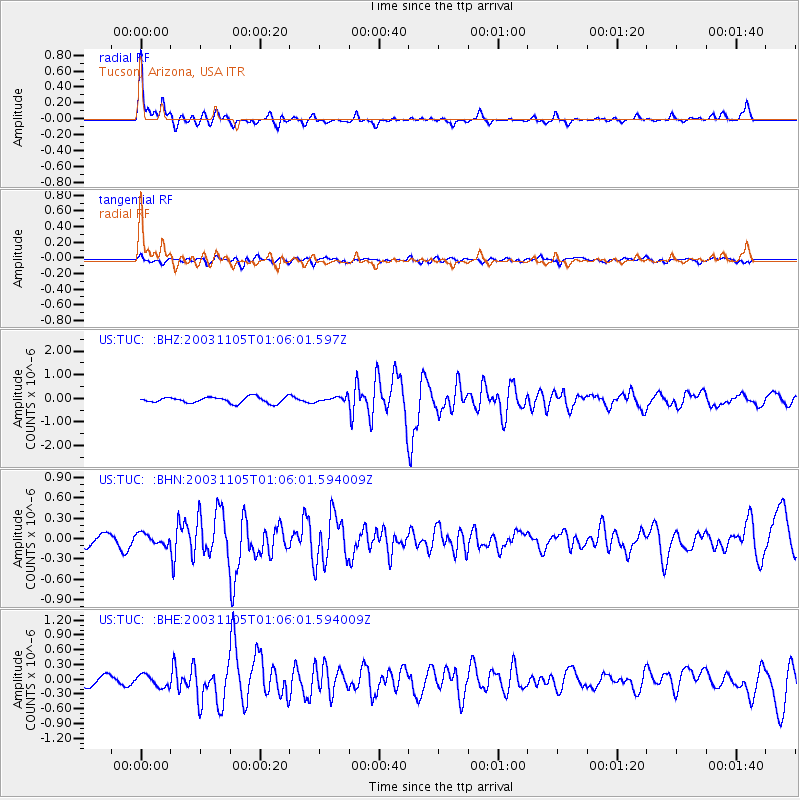
Signal To Noise
| Channel | StoN | STA | LTA |
| US:TUC: :BHN:20031105T01:06:01.594009Z | 1.4313893 | 8.029413E-8 | 5.6095242E-8 |
| US:TUC: :BHE:20031105T01:06:01.594009Z | 1.210019 | 1.252994E-7 | 1.0355159E-7 |
| US:TUC: :BHZ:20031105T01:06:01.597Z | 0.9012691 | 1.15667675E-7 | 1.2833867E-7 |
| Arrivals |
| Ps | 11 SECOND |
| PpPs | 29 SECOND |
| PsPs/PpSs | 40 SECOND |


