You are here: Home > Network List > US - United States National Seismic Network Stations List
> Station TUC Tucson, Arizona, USA > Earthquake Result Viewer
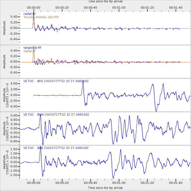
TUC Tucson, Arizona, USA - Earthquake Result Viewer

| Earthquake location: |
Fiji Islands Region |
| Earthquake latitude/longitude: |
-21.1/-176.6 |
| Earthquake time(UTC): |
2003/07/27 (208) 02:04:11 GMT |
| Earthquake Depth: |
213 km |
| Earthquake Magnitude: |
5.9 MB, 6.6 MW, 6.6 MW |
| Earthquake Catalog/Contributor: |
WHDF/NEIC |
|
| Network: |
US United States National Seismic Network |
| Station: |
TUC Tucson, Arizona, USA |
| Lat/Lon: |
32.31 N/110.78 W |
| Elevation: |
906 m |
|
| Distance: |
82.3 deg |
| Az: |
51.206 deg |
| Baz: |
239.268 deg |
| Ray Param: |
0.04646178 |
| Estimated Moho Depth: |
43.0 km |
| Estimated Crust Vp/Vs: |
1.89 |
| Assumed Crust Vp: |
6.276 km/s |
| Estimated Crust Vs: |
3.312 km/s |
| Estimated Crust Poisson's Ratio: |
0.31 |
|
| Radial Match: |
97.37386 % |
| Radial Bump: |
265 |
| Transverse Match: |
90.88723 % |
| Transverse Bump: |
400 |
| SOD ConfigId: |
110177 |
| Insert Time: |
2010-03-05 06:36:55.087 +0000 |
| GWidth: |
2.5 |
| Max Bumps: |
400 |
| Tol: |
0.001 |
|
Signal To Noise
| Channel | StoN | STA | LTA |
| US:TUC: :BHN:20030727T02:15:37.998018Z | 6.4617567 | 3.3605156E-7 | 5.2006225E-8 |
| US:TUC: :BHE:20030727T02:15:37.998018Z | 7.5088267 | 5.932687E-7 | 7.90095E-8 |
| US:TUC: :BHZ:20030727T02:15:37.998018Z | 33.856026 | 1.6373131E-6 | 4.8361052E-8 |
| Arrivals |
| Ps | 6.3 SECOND |
| PpPs | 19 SECOND |
| PsPs/PpSs | 26 SECOND |


