You are here: Home > Network List > US - United States National Seismic Network Stations List
> Station TUC Tucson, Arizona, USA > Earthquake Result Viewer
TUC Tucson, Arizona, USA - Earthquake Result Viewer

| Earthquake location: |
Hokkaido, Japan Region |
| Earthquake latitude/longitude: |
42.6/144.6 |
| Earthquake time(UTC): |
2003/10/08 (281) 09:06:55 GMT |
| Earthquake Depth: |
32 km |
| Earthquake Magnitude: |
6.0 MB, 6.6 MS, 6.7 MW, 6.6 MW |
| Earthquake Catalog/Contributor: |
WHDF/NEIC |
|
| Network: |
US United States National Seismic Network |
| Station: |
TUC Tucson, Arizona, USA |
| Lat/Lon: |
32.31 N/110.78 W |
| Elevation: |
906 m |
|
| Distance: |
78.4 deg |
| Az: |
56.758 deg |
| Baz: |
313.222 deg |
| Ray Param: |
0.049624678 |
| Estimated Moho Depth: |
10.25 km |
| Estimated Crust Vp/Vs: |
2.10 |
| Assumed Crust Vp: |
6.276 km/s |
| Estimated Crust Vs: |
2.996 km/s |
| Estimated Crust Poisson's Ratio: |
0.35 |
|
| Radial Match: |
89.4766 % |
| Radial Bump: |
385 |
| Transverse Match: |
81.268875 % |
| Transverse Bump: |
400 |
| SOD ConfigId: |
110177 |
| Insert Time: |
2010-03-05 06:37:06.494 +0000 |
| GWidth: |
2.5 |
| Max Bumps: |
400 |
| Tol: |
0.001 |
|
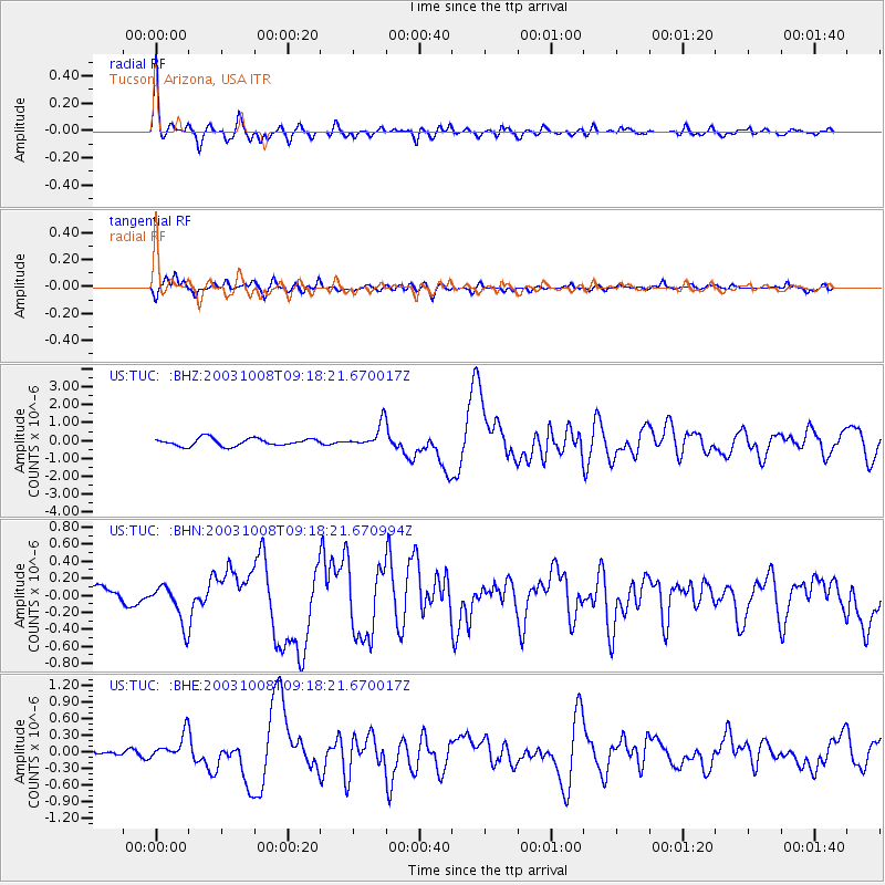
Signal To Noise
| Channel | StoN | STA | LTA |
| US:TUC: :BHN:20031008T09:18:21.670994Z | 1.9301617 | 2.3639835E-7 | 1.2247594E-7 |
| US:TUC: :BHE:20031008T09:18:21.670017Z | 4.220335 | 2.3646783E-7 | 5.6030583E-8 |
| US:TUC: :BHZ:20031008T09:18:21.670017Z | 3.119132 | 6.716879E-7 | 2.153445E-7 |
| Arrivals |
| Ps | 1.8 SECOND |
| PpPs | 4.9 SECOND |
| PsPs/PpSs | 6.8 SECOND |


